MyTopo
Weaverville California US Topo Map
Couldn't load pickup availability
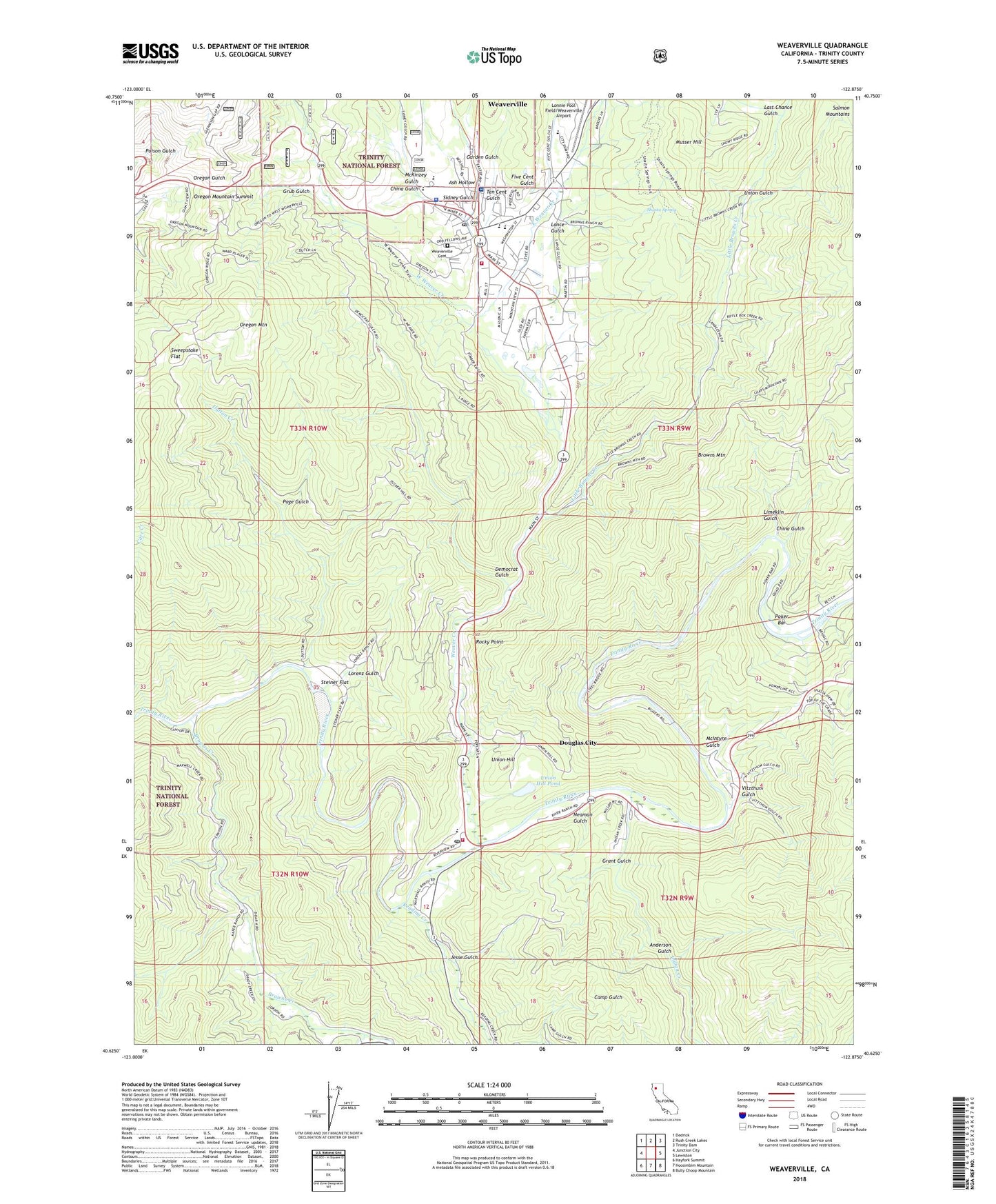
2022 topographic map quadrangle Weaverville in the state of California. Scale: 1:24000. Based on the newly updated USGS 7.5' US Topo map series, this map is in the following counties: Trinity. The map contains contour data, water features, and other items you are used to seeing on USGS maps, but also has updated roads and other features. This is the next generation of topographic maps. Printed on high-quality waterproof paper with UV fade-resistant inks.
Quads adjacent to this one:
West: Junction City
Northwest: Dedrick
North: Rush Creek Lakes
Northeast: Trinity Dam
East: Lewiston
Southeast: Bully Choop Mountain
South: Hoosimbim Mountain
Southwest: Hayfork Summit
This map covers the same area as the classic USGS quad with code o40122f8.
Contains the following named places: Anderson Gulch, Ash Hollow, Browns Creek, California Highway Patrol Weaverville, China Gulch, Croften Gulch, Democrat Gulch, Douglas City, Douglas City Campground, Douglas City Census Designated Place, Douglas City Elementary School, Douglas City Fire Department, Douglas City Post Office, Dutton Creek, East Weaver Creek, Five Cent Gulch, Garden Gulch, Grant Gulch, Grub Gulch, Highland Art Center, Indian Creek, Jesse Gulch, La Grange Mine, Lance Gulch, Last Chance Gulch, Limeklin Gulch, Little Browns Creek, Little Creek, Lonnie Pool Field/Weaverville Airport, Lorenz Gulch, Lowden Park, McIntyre Gulch, McKinzey Gulch, Musser Hill, Neaman Gulch, Oregon Mountain, Oregon Mountain Summit, Page Gulch, Poker Bar, Reading Creek, Readings Bar, River Meadows Campground, Rocky Point, Shasta Spring, Sidney Gulch, Steel Bridge Campground, Steiner Flat, Sweepstake Flat, Ten Cent Gulch, The Church of Jesus Christ of Latter Day Saints, Trinity Alps Golf Course, Trinity County Courthouse, Trinity County Law Library, Trinity County Library, Trinity County Life Support, Trinity County Sheriff's Office, Trinity High School, Trinity Hospital, Union Gulch, Union Hill, Union Hill Mine, Union Hill Pond, Veterans Memorial Hall, Vitzthum Gulch, Weaver Creek, Weaverville, Weaverville Cemetery, Weaverville Census Designated Place, Weaverville Church of the Nazarene, Weaverville Elementary School, Weaverville Historic District, Weaverville Joss House State Historic Park, Weaverville Post Office, Weaverville Ranger District Station, Weaverville Volunteer Fire Department, West Weaver Creek