MyTopo
Brighton Colorado US Topo Map
Couldn't load pickup availability
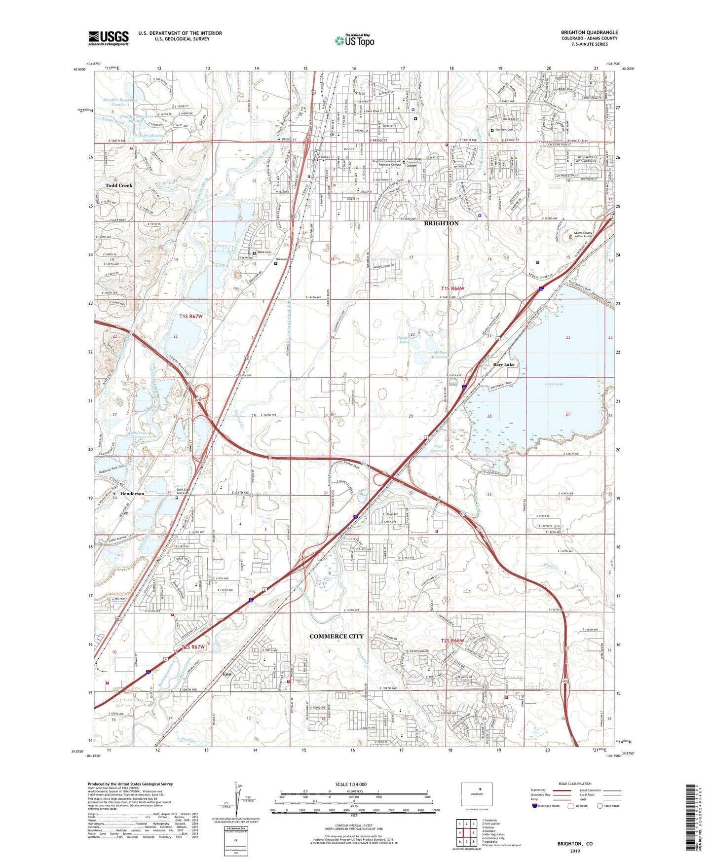
2022 topographic map quadrangle Brighton in the state of Colorado. Scale: 1:24000. Based on the newly updated USGS 7.5' US Topo map series, this map is in the following counties: Adams. The map contains contour data, water features, and other items you are used to seeing on USGS maps, but also has updated roads and other features. This is the next generation of topographic maps. Printed on high-quality waterproof paper with UV fade-resistant inks.
Quads adjacent to this one:
West: Eastlake
Northwest: Frederick
North: Fort Lupton
Northeast: Hudson
East: Mile High Lakes
Southeast: Denver International Airport
South: Montbello
Southwest: Commerce City
This map covers the same area as the classic USGS quad with code o39104h7.
Contains the following named places: Adams Aggregate Incorporated Pit, Adams County Detention Facility, Adams County Justice Center, Adams County Sheriff's Office Headquarters, Barr Lake, Barr Lake Dam, Benedict Park, Black Cemetery, Brighton, Brighton Adventist Academy, Brighton Division, Brighton Fire Rescue District Headquarters, Brighton Heritage Academy, Brighton High School, Brighton Learning and Resource Campus, Brighton Police Department, Brighton Post Office, Buffalo Run Golf Course, City of Brighton, Eagle Ridge Academy, Elmwood Baptist Academy, Elmwood Cemetery, Elmwood Church, Eno, Fairview Cemetery, First Creek, Foundations Academy, Fulton Ditch, Greater Brighton Fire Protection District Station 51, Greater Brighton Fire Protection District Station 52, Greater Brighton Fire Protection District Station 53, Greater Brighton Fire Protection District Station 55, Guthrie Number 1 Dam, Guthrie Number 2 Dam, Henderson, Henderson Airport, Henderson Elementary School, Henderson Island, Henderson Pit, Henderson Post Office, Higgins Dam, Higgins Lake, Houck Number 1 Dam, Houck Number 1 Reservoir, John W Thimmig Elementary School, Kilgore-Atchison Pit, KNUS-AM (Denver), Landmark Academy, Lutz Dam, Magers Reservoir, McCann Ditch, North Elementary School, Northeast Elementary School, Northglenn Ambulance - Henderson, Otho E Stuart Middle School, Overland Trail Middle School, Pennock Elementary School, Pikeview Dam, Pikeview Reservoir, Pikeview Reservoir Number 2, Platte Valley Ambulance Service, Platte Valley Medical Center, Platte Valley Medical Center - Emergency Medical Services, Pleasant Plains School, Prairie View High School, Prairie View Middle School, Reasoner Airport, Saint Augustine School, Saint Clair Ross Cemetery, Second Creek, Second Creek Elementary School, Skeel Reservoir Number 1, South Adams County Fire Department Station 26, South Adams County Fire Department Station 5, South Adams County Fire Department Station 7, South Adams County Fire Department Station 8, South Elementary School, Southeast Elementary School, Stouffer Reservoir Number Four, Stouffer Reservoir Number One, Stouffer Reservoir Number Three, Stouffer Reservoir Number Two, Stouffer Reservoirs, Tee Pee Construction Company Pit, Third Creek, Todd Creek, Todd Creek Census Designated Place, Turnberry Elementary School, Vail Dam, Vaile Reservoir, Vikan Middle School, Zion Lutheran School, ZIP Codes: 80022, 80601