MyTopo
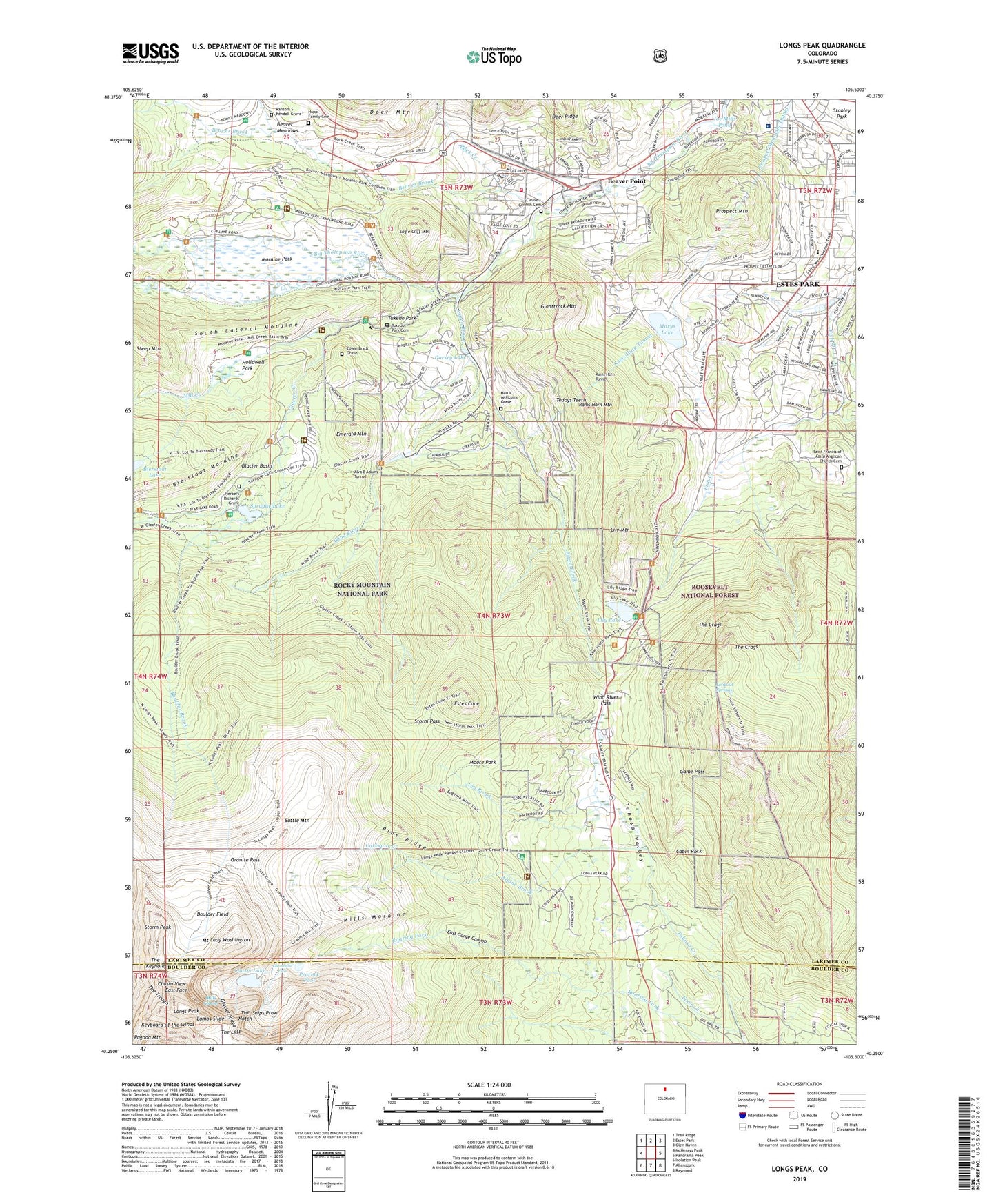
Longs Peak Colorado US Topo Map
Couldn't load pickup availability
Also explore the Longs Peak Forest Service Topo of this same quad for updated USFS data
2022 topographic map quadrangle Longs Peak in the state of Colorado. Scale: 1:24000. Based on the newly updated USGS 7.5' US Topo map series, this map is in the following counties: Larimer, Boulder. The map contains contour data, water features, and other items you are used to seeing on USGS maps, but also has updated roads and other features. This is the next generation of topographic maps. Printed on high-quality waterproof paper with UV fade-resistant inks.
Quads adjacent to this one:
West: McHenrys Peak
Northwest: Trail Ridge
North: Estes Park
Northeast: Glen Haven
East: Panorama Peak
Southeast: Raymond
South: Allenspark
Southwest: Isolation Peak
This map covers the same area as the classic USGS quad with code o40105c5.
Contains the following named places: Agnes Vaille Memorial Shelter, Alpine Brook, Aspen Brook, Aspen Creek Siphon, Battle Mountain, Beaver Brook, Beaver Meadows, Beaver Meadows Entrance, Beaver Point, Big Owl Hill, Boulder Brook, Boulder Brook Trail, Boulder Field, Buck Creek, Butterfly Burn, Cabin Rock, Chasm Lake, Chasm View, Cheley Camp, Cleave - Griffith Cemetery, Columbine Falls, Dorsey Lake, Eagle Cliff Mountain, East Face, East Fork Fish Creek, East Gorge Canyon, East Longs Peak Trail, East Portal, Edwin Bradt Grave, Emerald Mountain, Estes Cone, Estes Park Center/YMCA of the Rockies, Estes Park Medical Center, Estes Park Medical Center Ambulance, Estes Park Post Office, Estes Pit, Estes Valley Fire Protection District Station 2, Eugenia Mine, Fawn Creek, Game Pass, Gianttrack Mountain, Glacier Basin, Glacier Basin Campground, Glacier Creek, Glacier Ridge, Granite Pass, Harris Wellcome Grave, Herbert Richards Grave, Hollowell Park, Hupp Family Cemetery, Inn Brook, Jims Grove, Joe Mills Pond, Keyboard of the Winds, KSIR-AM (Estes Park), Lambs Slide, Larkspur Creek, Lily Lake, Lily Mountain, Lily Mountain Trail, Long Peak Trail, Longs Peak, Longs Peak Campground, Longs Peak Ranger Station, Lookout Springs, Marys Lake, Marys Lake Dike Number 1 Dam, Marys Lake Dike Number 2 Dam, Mill Creek, Mills Glacier, Mills Moraine, Moore Park, Moraine Park, Moraine Park Campground, Moraine Park Visitor Center, Moss Brook, Mount Lady Washington, Peacock Pool, Pine Ridge, Prospect Mountain, Prospect Mountain Tunnel, Rams Horn Mountain, Rams Horn Tunnel, Ransom S Kendall Grave, Rocky Mountain National Park Administration Building, Saint Francis of Assisi Anglican Church Cemetery, Shelter House, Ships Prow, South Lateral Moraine, Sprague Lake, Steep Mountain, Storm Pass, Storm Pass Trail, Storm Peak, Teddys Teeth, The Crags, The Dove, The Keyhole, The Loft, The Notch, The Trough, Town of Estes Park, Tuxedo Park, Tuxedo Park Cemetery, Twin Sister Trail, Twin Sisters Mountain, Twin Sisters Peaks, Wind River, Wind River Pass, Wind River Trail, ZIP Code: 80511