MyTopo
Branford Connecticut US Topo Map
Couldn't load pickup availability
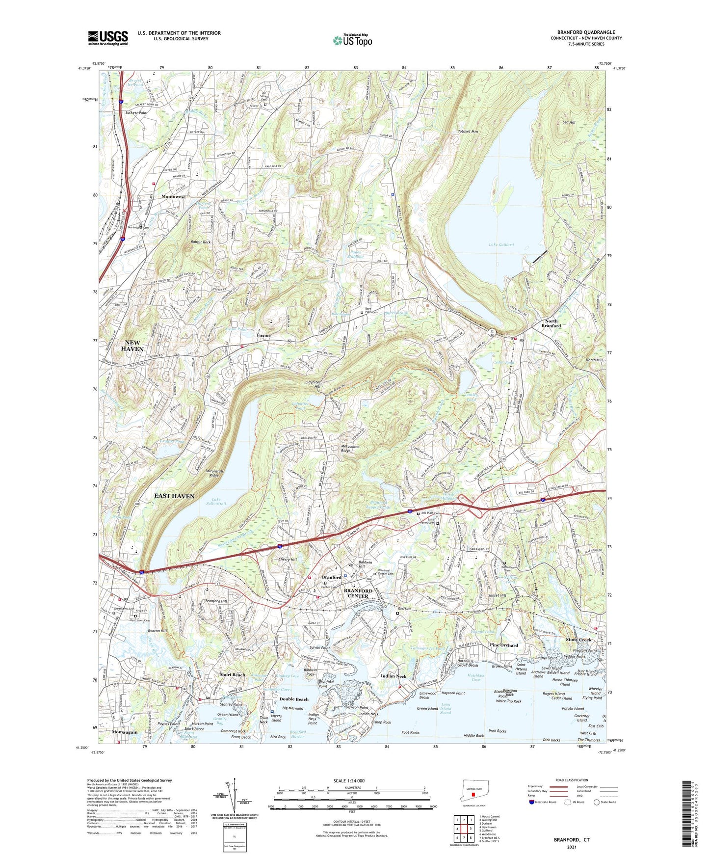
2024 topographic map quadrangle Branford in the state of Connecticut. Scale: 1:24000. Based on the newly updated USGS 7.5' US Topo map series, this map is in the following counties: New Haven. The map contains contour data, water features, and other items you are used to seeing on USGS maps, but also has updated roads and other features. This is the next generation of topographic maps. Printed on high-quality waterproof paper with UV fade-resistant inks.
Quads adjacent to this one:
West: New Haven
Northwest: Mount Carmel
North: Wallingford
Northeast: Durham
East: Guilford
Southeast: Guilford OE S
South: Branford OE S
Southwest: Woodmont
This map covers the same area as the classic USGS quad with code o41072c7.
Contains the following named places: Academy on the Green, Access Ambulance Service SKMP Enterprises, All Saints Cemetery, Alling Memorial Golf Course, Andrews Island, Augurs Ice Pond, Baldwin Hill, Baldwin Rock, Bare Plain Cemetery, Beacon Hill, Beaver Swamp Brook, Belden Island, Big Mermaid, Bird Rock, Bishop Rock, Bishop Woods School, Blackstone Rocks, Bowman Rock, Branford, Branford Center Cemetery, Branford Center Census Designated Place, Branford Center Historic District, Branford Counseling Center, Branford Cove, Branford Craft Village Shopping Center, Branford Fire Department Headquarters, Branford Fire Department Indian Neck Company 9, Branford Fire Department M P Rice Company 2, Branford Fire Department Short Beach Company 4, Branford Fire Department Stony Creek Company 5, Branford Harbor, Branford High School, Branford Hill, Branford Hills, Branford Hills Plaza Shopping Center, Branford Hills School, Branford Point, Branford Point Historic District, Branford Post Office, Branford Square Shopping Center, Branford Supply Ponds, Branford Supply Ponds Dam, Branhaven Shopping Center, Brown Point, Bruces Ice Pond, Brushy Hill Shopping Center, Burr Island, Burrs Brook, Camp Hubinger, Canoe Brook School, Cedar Island, Cedar Lake School, Cedar Pond, Center Cemetery, Central Shopping Plaza Shopping Center, Cherry Hill, Cherry Hill Shopping Center, Community House, Connecticut State Boat Launching Area, Connecticut Trolley Museum, Crooked Brook, D C Moore School, Damascus Cemetery, Deer Run School, Democrat Rock, Dick Rocks, Dominic H Ferrara School, Double Beach, East Crib, East Haven, East Haven Academy, East Haven Census Designated Place, East Haven Fire Department Headquarters, East Haven Fire Department Station 3, East Haven Fire Department Station 4, East Haven Fire Department Station 6, East Haven Marsh Wildlife Area, East Lawn Cemetery, Farm River Gut, Fivemile Brook, Flying Point, Foot Rocks, Foote Memorial Park, Foxon, Foxon Pond, Francis Walsh Intermediate School, Frisbie Island, Front Beach, Gillis School, Governor Island, Graniss Pond, Graniss Pond Dam, Granite Bay, Grant Oak Shopping Center, Green Island, Greenlawn Cemetery, Griffins Pond, Hagaman Memorial Library, Hammer Field, Harbor Street School, Harrison Avenue School, Hartens Pond, Haycock Point, Hays School, Highland School, Horton Point, Hotchkiss Cove, Hotchkiss Grove Beach, House Chimney Island, Indian Neck, Indian Neck Point, Indian Neck School, James Blackstone Memorial Library, Jerome Harrison School, John B Sliney School, Joseph Melillo Middle School, Juniper Point, Kelsey Island, Kennedy Field, Lake Gaillard, Lake Gaillard Dam, Lake Saltonstall, Lake Saltonstall Dam, Lamphier Cove, Laurel Street School, Lewis Island, Lidyhites Hill, Lidyhites Pond, Limewood Beach, Lindsey Cove, Linsley Pond, Lions Park, Lockworks Shopping Center, Lovers Island, Maloney Brook, Market Place Shopping Center, Mary R Tisko School, Mary T Murphy School, Michael Street Park, Middle Rock, Mill Plain Cemetery, Montowese, Montowese Cemetery, Montowese Elementary School, Montowese Shopping Plaza Shopping Center, Muddy River, Munger Brook, Nelson Ambulance, Nelson Ambulance Service SKMP Enterprises, North Branford, North Branford Fire Department Company 1, North Branford Heliport, North Branford High School, North Branford Intermediate School, North Branford Police Department, North Branford Post Office, North Branford Town Hall, North Haven Fire Department Montowese Volunteer Fire Company, North Haven High School, North Haven Middle School, Notch Hill, Notch Hill Brook, Orchard Hill Plaza Shopping Center, Pages Cove, Pages Millpond, Pages Millpond Dam, Parker Memorial Park, Pawnson Park, Pawson Park Marsh Wildlife Area, Pawson Point, Paynes Point, Peters Rock Park, Pine Orchard, Pine Orchard Club, Pine Orchard School, Pirot Pond, Pisgah Brook, Pleasant Point, Pork Rocks, Potato Island, Rabbit Rock, Robert W Carbone School, Rogers Island, Rose Swamp, Roses Brook, Sackett Point, Saint Agnes Cemetery, Saint Helena Island, Saint Marys School, Saltonstall Ridge, Sea Hill, Short Beach, Short Beach Post Office, Stanley Point, Stony Creek Post Office, Stony Creek-Thimble Island Historic District, Sunset Hill, Supply Pond Park, Sylvan Point, Tabor Cemetery, Talmage Pond, Talmages Ice Pond, The Connecticut Hospice, The Thimbles, Thompson Corner, Totoket, Totoket Historical Society Building, Town Neck, Town of Branford, Town of East Haven, Town of North Branford, Trolley Museum, Trolley Square Post Office, Trolley Square Shopping Center, Tuttle Bridge, Tuttle Elementary School, Twin Lakes Golf Course, USSC/NH Heliport, Veddar Point, Vernon Hays School, Veterans Memorial Park, Village Street School, Wards Millpond, Wards Millpond Dam, West Crib, Wheeler Island, White Top Rock, Wightwood School, Willoughby Wallace Memorial Library, WTVU-TV (New Haven), Youngs Pond, Youngs Pond Park, ZIP Codes: 06405, 06471, 06513