MyTopo
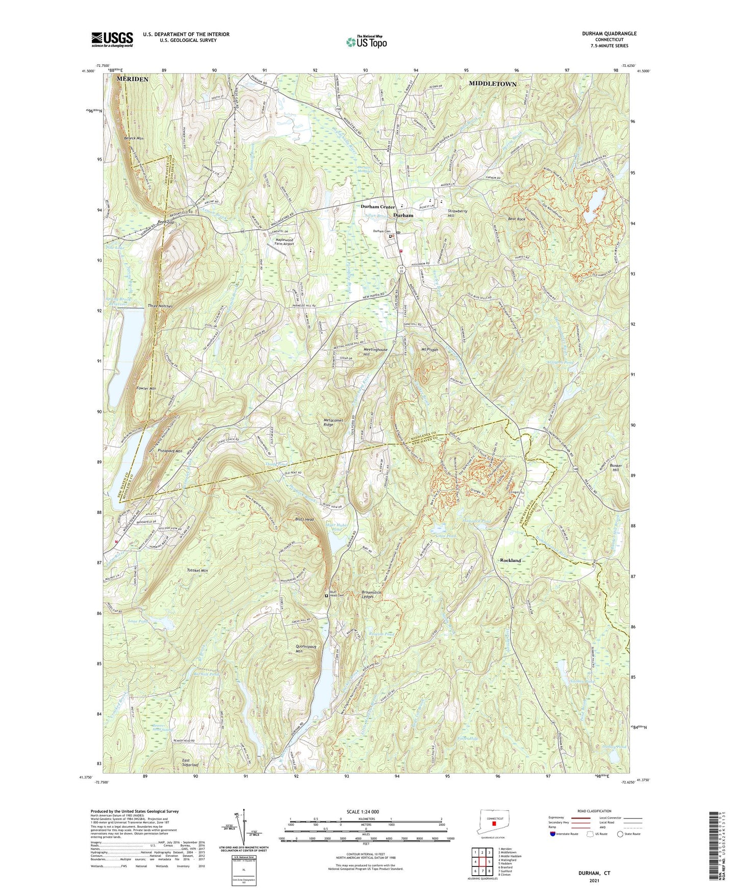
Durham Connecticut US Topo Map
Couldn't load pickup availability
2024 topographic map quadrangle Durham in the state of Connecticut. Scale: 1:24000. Based on the newly updated USGS 7.5' US Topo map series, this map is in the following counties: Middlesex, New Haven. The map contains contour data, water features, and other items you are used to seeing on USGS maps, but also has updated roads and other features. This is the next generation of topographic maps. Printed on high-quality waterproof paper with UV fade-resistant inks.
Quads adjacent to this one:
West: Wallingford
Northwest: Meriden
North: Middletown
Northeast: Middle Haddam
East: Haddam
Southeast: Clinton
South: Guilford
Southwest: Branford
This map covers the same area as the classic USGS quad with code o41072d6.
Contains the following named places: Allyn Brook, Allyn Millpond, Arrigoni Pond, Arrigoni Pond Dam, Asmun Brook, Ball Brook, Bartlett Pond, Bear Rock, Beaver Head Corner, Beaver Head Swamp, Bluff Head, Bluff Head Cemetery, Brewster School, Broomstick Ledges, Bunker Hill, Bunker Hill Brook, Chalker Brook, Church of the Epiphany, Coan Pond, Coginchaug Regional High School, Cream Pot Brook, Dudley Pond, Durham, Durham Census Designated Place, Durham Center, Durham Meadows, Durham Meadows Hunting Area, Durham Post Office, Durham Public Library, Durham Volunteer Ambulance, Durham Volunteer Fire Company, East Sugarloaf, Foster Hole, Fowler Mountain, Fowley Brook, Guilford Lookout Tower, Guilford Town Park, Hemlock Brook, Hersig Brook, Korn School, Lane Pond, Lane Pond Dam, Linmar Dairy Farm, Lyman Meadow Golf Club, Main Street Historic District, Maplewood Farm Airport, Mattabesset Trail, Meetinghouse Hill, Menuckatuck Reservoir, Menuckatuck Reservoir Dam, Miller Pond Dam, Millers Pond, Millers Pond State Park, Mount Pisgah, Myer Huber Pond, Nathan Pond, North Branford Fire Department Company 3, Notre Dame Church, Parmalee Brook, Pine Lake, Pistapaug Mountain, Pistapaug Pond, Pistapaug Pond Dam, Pond Brook, Quonnipaug Lake, Quonnipaug Lake Dam, Quonnipaug Mountain, Reed Gap, Reeds Gap Heliport, Rockland, Ruscom Pond, Sawmill Brook, Stannard Pond, Stony Brook, Strawberry Hill, Strong School, Sucker Brook, Tetram Pond, Tetram Pond Dam, Thody Pond, Three Notches, Town of Durham, Trimountain State Park, Ulbrich Reservoir, Ulbrich Reservoir Dam, Washington Trail, William J Ulbrich Reservoir, YMCA Pond, YMCA Pond Dam, ZIP Code: 06422