MyTopo
Jewett City Connecticut US Topo Map
Couldn't load pickup availability
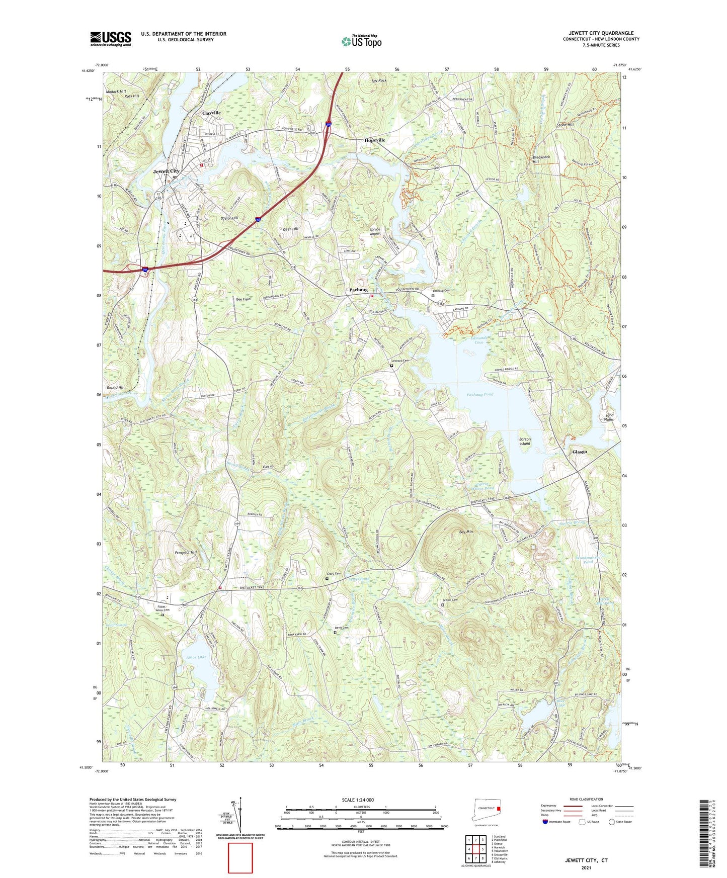
2024 topographic map quadrangle Jewett City in the state of Connecticut. Scale: 1:24000. Based on the newly updated USGS 7.5' US Topo map series, this map is in the following counties: New London. The map contains contour data, water features, and other items you are used to seeing on USGS maps, but also has updated roads and other features. This is the next generation of topographic maps. Printed on high-quality waterproof paper with UV fade-resistant inks.
Quads adjacent to this one:
West: Norwich
Northwest: Scotland
North: Plainfield
Northeast: Oneco
East: Voluntown
Southeast: Ashaway
South: Old Mystic
Southwest: Uncasville
This map covers the same area as the classic USGS quad with code o41071e8.
Contains the following named places: American Legion Ambulance, Amos Lake, Anderson Pond, Ashland Pond, Ashland Pond Dam, Ashwillet Brook, Ashwillet School, Aspinook Pond Dam, Ayers Brook, Barton Island, Bay Mountain, Bee Field, Bethel, Bethel Church, Billings Brook, Billings Lake, Billings Lake Dam, Blue Lake, Blue Lake Dam, Borough of Jewett City, Breakneck Hill, Broad Brook, Brown Cemetery, Burton Brook, Calvary Bible Church, Calvin Wilcox Pond, Campers World Campground, Clayville, Clayville Pond, Crary Cemetery, Crooked Brook, Cutler Brook, Davis Cemetery, Doaneville, Dorrville, Edmonds Brook, Edmonds Cove, First Congregational Church, Fobes - Amos Cemetery, Folly Works Brook, Geer Hill, Glasgo, Glasgo Pond, Glasgo Pond Dam, Glasgo Post Office, Glasgo School, Grist Mill Pond, Griswald Fire Company, Griswold Fire Marshal's Office, Griswold High School, Griswold Volunteer Fire Department Station 55, Hopeville, Hopeville Pond, Hopeville Pond Dam, Hopeville Pond State Park, Jewett City, Jewett City Baptist Church, Jewett City Fire Department, Jewett City Post Office, Jewett City Resident State Patrol Office, Jewett City Town Hall, Lakeside Airport, Leonard Cemetery, Lewis Pond, Miller Brook, Norman Brook, Northwest Corner School, Pachaug, Pachaug Cemetery, Pachaug Green, Pachaug Pond, Pachaug Pond Dam, Pachaug River, Pachaug School, Pachaug State Forest, Partridge Brook, Popple Bridge, Prentice Brook, Preston City, Preston City Congregational Church, Preston City Fire Company, Preston City Historic District, Preston City School, Preston Highway Park, Preston School, Prospect Hill, Rattlesnake Brook, Ross Hill, Ross Hill Campgrounds, Round Hill, Saint Catherine Church, Saint Marys Church, Sand Plains, Second Congregational Church, Sheep Barn Brook, Spruce Airport, Spy Rock, Sterrie Brook, Stickmeadow, Stone Hill, Taylor Hill, Town of Griswold, Woodmansee Pond, YMCA Camp, ZIP Code: 06351