MyTopo
Plainfield Connecticut US Topo Map
Couldn't load pickup availability
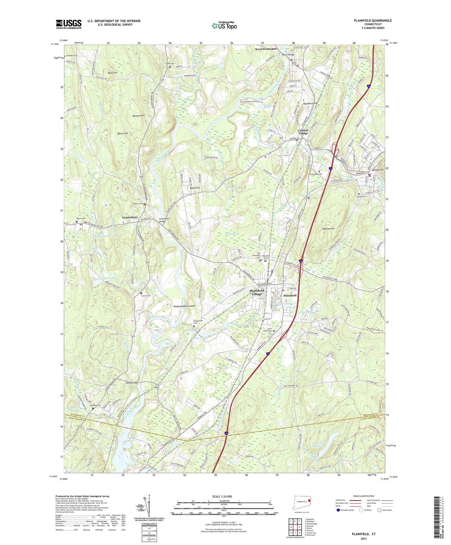
2024 topographic map quadrangle Plainfield in the state of Connecticut. Scale: 1:24000. Based on the newly updated USGS 7.5' US Topo map series, this map is in the following counties: Windham, New London. The map contains contour data, water features, and other items you are used to seeing on USGS maps, but also has updated roads and other features. This is the next generation of topographic maps. Printed on high-quality waterproof paper with UV fade-resistant inks.
Quads adjacent to this one:
West: Scotland
Northwest: Hampton
North: Danielson
Northeast: East Killingly
East: Oneco
Southeast: Voluntown
South: Jewett City
Southwest: Norwich
This map covers the same area as the classic USGS quad with code o41071f8.
Contains the following named places: Aldrich Free Public Library, All Hallows Church, All Hallows Convent, American Legion Ambulance, Angell Brook, Apple Tree Meadow Brook, Aspinook Pond, Atwood Hose Fire Company Station 96, Baldwin Cemetery, Bennett Brook, Bennett Pond, Black Hill, Blackwell Brook, Buck Hill, Burr Smith Pond, Butts Bridge, Calvary Chapel, Canterbury, Canterbury Bridge, Canterbury Elementary School, Canterbury Green, Canterbury Post Office, Canterbury Volunteer Fire Department, Carey Cemetery, Cedar Swamp, Center Cemetery, Central Assembly of God Church, Central Village, Central Village Congregational Church, Central Village Fire Department Station 97, Central Village Post Office, Church of the Living God, Cold Spring Brook, Cone Brook, Cory Brook, Darby Brook, Doctor Helen Baldwin Middle School, Ekonk Brook, Evans Pond, Evergreen Cemetery, Faith Community Church, First Congregational Church, First Congregational Church of Plainfield, Frank Bennett Pond, Havey Brook, Holmes Hill, Horse Brook, Hyde Cemetery, Kitt Brook, Lathrop Brook, Mill Brook, Moosup, Moosup Baptist Church, Moosup Census Designated Place, Moosup Elementary School, Moosup Fire Department Station 94, Moosup Post Office, Moosup River, Morgan Hill, Mudhole Brook, New Plainfield Cemetery, North Hill, Old Plainfield Cemetery, Open Bible Baptist Church, Packer, Packers Pond, Packers Pond Dam, Packerville Baptist Church, Packerville Cemetery, Palmer Brook, Peagscomsuck Island, Pierce Bridge, Plainfield, Plainfield Academy, Plainfield Cemetery, Plainfield Central School, Plainfield Fire Company 1 Station 95, Plainfield Fire Marshal's Office, Plainfield Industrial Park, Plainfield Parkade Shopping Center, Plainfield Police Department, Plainfield Public Library, Plainfield Street Historic District, Plainfield Village Census Designated Place, Plains Cemetery, Prudence Crandall Museum, Prudence Crandall Museum Library, Quinebaug Valley Trout Hatchery, Rams Athletic Field, Reservoir Brook, Saint Augustines Church, Saint John the Apostle Church, Saint Johns Cemetery, Saint Pauls Episocpal Church, Shepard Hill Elementary School, Shepherd Hill, Stone Hill Reservoir, Stone Hill Reservoir Dam, Sugar Brook, Tatnic Brook, Town of Canterbury, Town of Plainfield, Union Cemetery, Wauregan, Wauregan Census Designated Place, Wauregan Historic District, Wauregan Post Office, Wauregan Station, West Wauregan, Wheeler Cemetery, ZIP Codes: 06332, 06374, 06387