
MyTopo
Barnesville Georgia US Topo Map
Couldn't load pickup availability
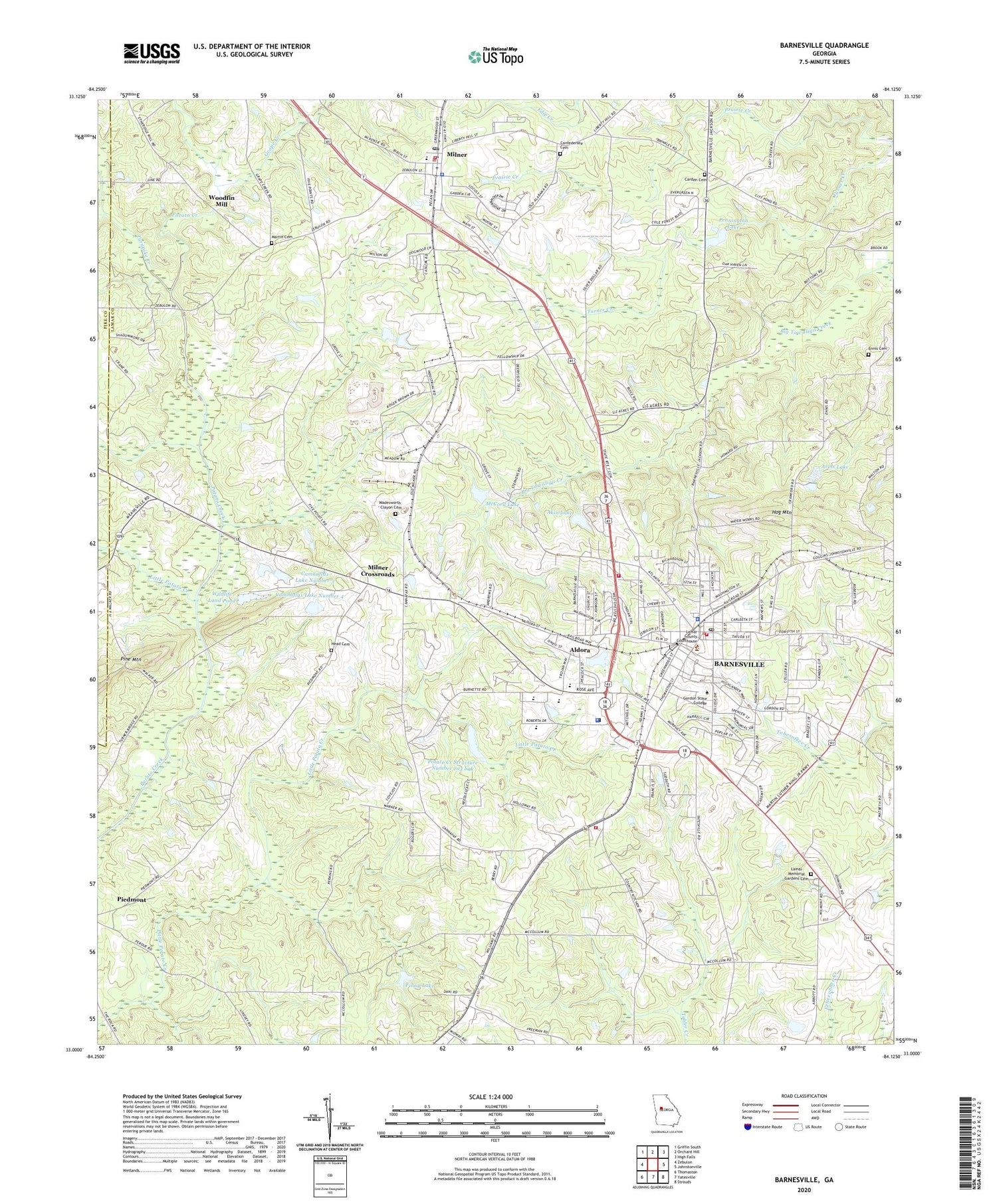
2024 topographic map quadrangle Barnesville in the state of Georgia. Scale: 1:24000. Based on the newly updated USGS 7.5' US Topo map series, this map is in the following counties: Lamar, Pike. The map contains contour data, water features, and other items you are used to seeing on USGS maps, but also has updated roads and other features. This is the next generation of topographic maps. Printed on high-quality waterproof paper with UV fade-resistant inks.
Quads adjacent to this one:
West: Zebulon
Northwest: Griffin South
North: Orchard Hill
Northeast: High Falls
East: Johnstonville
Southeast: Strouds
South: Yatesville
Southwest: Thomaston
This map covers the same area as the classic USGS quad with code o33084a2.
Contains the following named places: Akin Lake, Akin Lake Dam, Aldora, Arms Lake, Arms Lake Dam, Barnesville, Barnesville Academy, Barnesville City Hall, Barnesville Division, Barnesville Fire Department, Barnesville Police Department, Barnesville Post Office, Bethel Church, Birch Street School, Calvary Church, Camnaflax Lake Dam Number 3, Camnaflax Lake Dam Number 4, Camnaflax Lake Number 3, Camnaflax Lake Number 4, Carden Cemetery, Carnegie Library of Barnesville, City of Barnesville, City of Milner, Confederate Cemetery, Ebenezer Church, Ennis Cemetery, Finny Lake, Finny Lake Dam, First Baptist Church, Forsyth Road School, Gordon College, Graddick, Graham Street School, Grape Creek, Greater Spring Hill Missionary Baptist Church Cemetery, Greenwood Cemetery, Hardin Creek, Head Cemetery, Hog Mountain, Holly Grove Church, Holly Grove School, Kingdom Hall, Lamar County, Lamar County Comprehensive High School, Lamar County Courthouse, Lamar County Elementary School, Lamar County Fire and Rescue Station 1 Grove Street, Lamar County Fire Department and Rescue Station 3 South Milner, Lamar County Jail, Lamar County Middle School, Lamar County Primary School, Lamar County Sheriff's Office, Lamar Memorial Gardens Cemetery, Lamar Pre-Release Center, Lilla Church, Little Potato Creek, Martin Cemetery, McCord Lake, McCord Lake Dam, Midway Church, Midway Church Cemetery, Midway School, Milner, Milner Church Cemetery, Milner Cross Roads School, Milner Crossroads, Milner Police Department, Milner Post Office, Mount Calvary Church, Mount Pleasant Church, Mount Sinai Church Cemetery, Mount Zion Church, Mount Zion Church Cemetery, Pennington Lake, Pennington Lake Dam, Pepper Creek, Pine Mountain, Potato Creek Structure Number 103 Dam, Potato Creek Structure Number 103 Lak, Powell, Revere, Saint George's Episcopal School, Stroudsville School, Town of Aldora, Turner Creek, Turnpike Creek, Wadesworth - Clayon Cemetery, WBAF-AM (Barnesville), Wildlife Land Pond, Wildlife Land Pond Dam, Wilkinsons, Woodfin Lake, Woodfin Mill, Zebulon Street Cemetery


