MyTopo
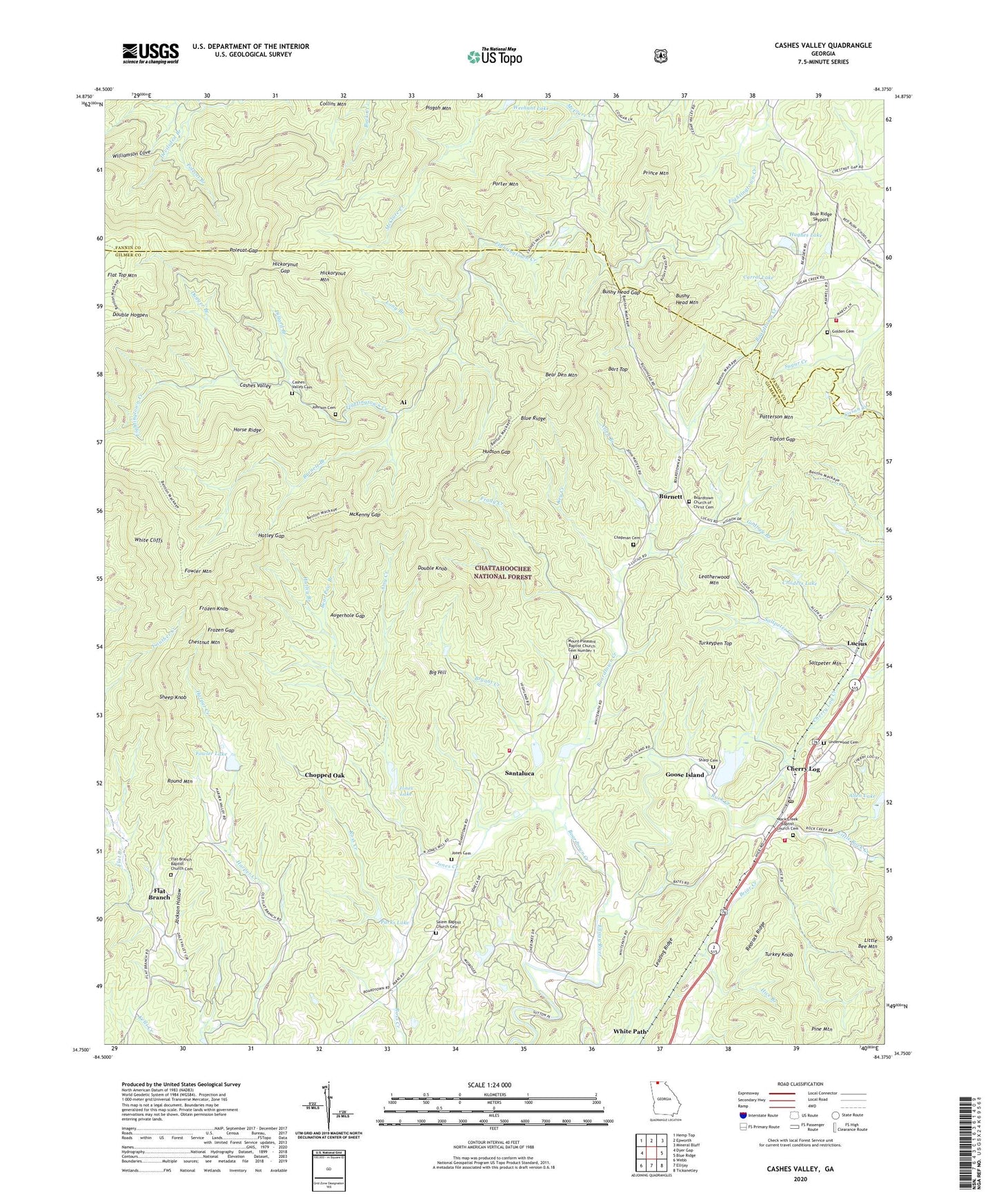
Cashes Valley Georgia US Topo Map
Couldn't load pickup availability
Also explore the Cashes Valley Forest Service Topo of this same quad for updated USFS data
2024 topographic map quadrangle Cashes Valley in the state of Georgia. Scale: 1:24000. Based on the newly updated USGS 7.5' US Topo map series, this map is in the following counties: Gilmer, Fannin. The map contains contour data, water features, and other items you are used to seeing on USGS maps, but also has updated roads and other features. This is the next generation of topographic maps. Printed on high-quality waterproof paper with UV fade-resistant inks.
Quads adjacent to this one:
West: Dyer Gap
Northwest: Hemp Top
North: Epworth
Northeast: Mineral Bluff
East: Blue Ridge
Southeast: Tickanetley
South: Ellijay
Southwest: Webb
This map covers the same area as the classic USGS quad with code o34084g4.
Contains the following named places: Ai, Allen Branch, Allen Lake, Amy Creek, Augerhole Gap, Bart Top, Bear Den Mountain, Bear Paw Branch, Big Hill, Blue Ridge Skyport, Boardtown Church, Boardtown Church of Christ Cemetery, Boardtown Creek, Boardtown School, Bryant Creek, Burnett, Burnett Branch, Bushy Head Gap, Bushy Head Mountain, Carrol Lake, Carrol Lake Dam, Cashes Valley, Cashes Valley Cemetery, Cashes Valley Church of Christ, Cashes Valley School, Chapman Cemetery, Cherry Log, Cherry Log Census Designated Place, Cherry Log Creek, Cherry Log Division, Cherry Log Post Office, Chestnut Mountain, Childers Lake, Childers Lake Dam, Chopped Oak, Church of Christ, Collins Mountain, Devilsden Branch, Dillard Branch, Double Hogpen, Double Knob, Dugger Branch, Ellijay Watershed Dam Number 10, Ellijay Watershed Dam Number Four, Ellijay Watershed Dam Number Nine, Ellijay Watershed Dam Number Two, Ellijay Watershed Number Three Dam, Flat Branch, Flat Branch Baptist Church Cemetery, Flat Branch Church, Flat Branch School, Fowler Lake, Fowler Lake Dam, Fowler Mountain, Frady Creek, Frozen Gap, Frozen Knob, Gilmer County Country Club, Gilmer County Fire Department Station 3, Gilmer County Fire Department Station 5, Godfrey Branch, Golden Cemetery, Goose Island, Goose Island Lake, Harper Creek, Harper School, Hatley Branch, Hatley Gap, Hensley Lake, Hensley Lake Dam, Hice Branch, Hickorynut Gap, Hickorynut Mountain, Higdon Mill, Horse Ridge, Hudson Gap, Hughes Lake, Jackson Hollow, Johnson Cemetery, Jones Cemetery, Jones Creek, Jones Lake, Jones Mill, Key Creek, Leading Ridge, Leatherwood Mountain, Little Bee Mountain, Little Rock Creek, Long Branch, Lucius, Macedonia Church, Macedonia School, McKenny Gap, Mount Pleasant Baptist Church Cemetery Number 1, Mount Pleasant Church, Parks Lake, Patterson Mountain, Persimmon Gap, Pine Mountain, Polecat Branch, Polecat Gap, Porter Mountain, Postelle Creek, Prince Mountain, Prince Mountain Academy, Redbush School, Redrock Ridge, Rock Creek, Rock Creek Baptist Church Cemetery, Rock Creek Church, Rocky Creek School, Round Mountain, Salem Baptist Church, Salem Baptist Church Cemetery, Saltpeter Creek, Saltpeter Mountain, Santaluca, Sharp Cemetery, Shaw Lake, Shaw Lake Dam, Sheep Knob, Tipton Gap, Turkey Knob, Turkeypen Top, Underwood Cemetery, White Cliffs, White Path, Williamson Cove, Young Lake Dam, Youngs Chapel