MyTopo
Dillard Georgia US Topo Map
Couldn't load pickup availability
Also explore the Dillard Forest Service Topo of this same quad for updated USFS data
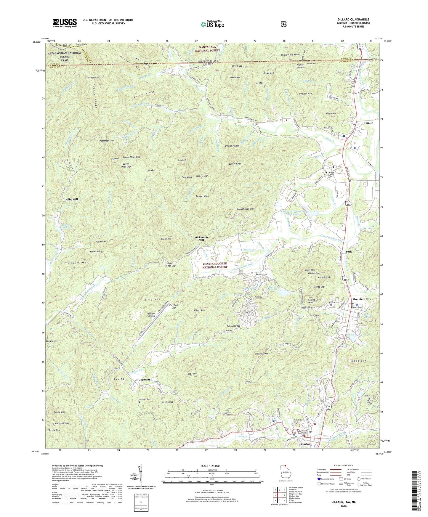
2024 topographic map quadrangle Dillard in the states of Georgia, North Carolina. Scale: 1:24000. Based on the newly updated USGS 7.5' US Topo map series, this map is in the following counties: Rabun, Macon, Clay. The map contains contour data, water features, and other items you are used to seeing on USGS maps, but also has updated roads and other features. This is the next generation of topographic maps. Printed on high-quality waterproof paper with UV fade-resistant inks.
Quads adjacent to this one:
West: Hightower Bald
Northwest: Rainbow Springs
North: Prentiss
Northeast: Scaly Mountain
East: Rabun Bald
Southeast: Rainy Mountain
South: Tiger
Southwest: Lake Burton
Contains the following named places: Almond Bald, Arnold Branch, Asa Cove, Ashley Creek, Barkers Creek, Beavert Branch, Beavert Mountain, Betty Creek, Betty Creek Church, Bettys Creek Recreation Area, Big Face, Billy Creek, Billy Mountain, Black Rock Church, Black Rock Lake, Black Rock Lake Dam, Black Rock Mountain State Park, Blackrock Mountain, Blacks Branch, Blacks Creek, Blue Heights Church, Blue Ridge Gap, Boardpile Branch, Camp Barron, Camp Dixie, Carson Branch, Carter Gap, Cedar Knob, City of Clayton, City of Dillard, Clayton, Clayton Division, Clayton Elementary School, Clayton Police Department, Clayton Post Office, Coffee Branch, Coleman River Wildlife Management Area, Commissioner Creek, Covered Bridge Plaza Shopping Center, Covered Bridge Shopping Center, Cox Lake, Cox Lake Dam, Darling Spring, Darnell Creek, Darnell Gap, Devils Branch, Dickerson Mill, Dillard, Dillard Police Department, Dillard Post Office, Double Branch, Double Knob, Drive Ridge, Edmonds Top, Elisha Mountain, Fairview Church, Falls Branch, First Prong, George Mountain, Germany, Germany Cemetery, Gibson Gap, Grassy Ridge, Greasy Creek, Gulf Branch, Gulf Knob, Hambidge Center Historic District, Head of Tennessee Baptist Church, Heaven's Landing, Hightower Branch, Hog Mountain, Hopper Branch, Howard Creek, Howard Gap, Howard Mountain, Jerry Branch, Joe Gap, Jones Mountain, Keener Branch, Keener Creek, Keener Mountain, Kilby Branch, Kilby Mill, Lamb Creek, Ledford Branch, Ledford Mountain, Little Creek, Locust Post, Lookoff Mountain, Marsen Knob, McCurry Cemetery, Messer Creek, Messer Ridge, Millers Mill, Moore Girls Mine, Mount Olive Church, Mountain City, Mountain City Police Department, Mountain City Post Office, Mountain Grove Church, Mountain Lakes Medical Center, Mud Creek, Needy Creek, Negro Branch, Nichols Gap, Norton Creek, Oakey Mountain, Owen Branch, Owen Gap, Owen Mountain, Patterson Creek, Patterson Gap, Penson Knob, Pickett Cemetery, Pinnacle Knob, Pitt Branch, Poplar Cove, Poplar Cove Gap, Poplar Cove Knob, Potato Hill, Queen Mine Gap, Queen Mine Knob, Rabun County, Rabun County Courthouse, Rabun County Fire Services, Rabun County Marshal's Office, Rabun County Memorial Hospital, Rabun County Sheriff's Office, Rabun Gap, Rabun Gap Academy, Rabun Gap Community School, Rabun Gap Nacoochee School, Rabun Gap Nacoochee School Lake, Rabun Gap Nacoochee School Lake Dam, Rabun Gap Post Office, Rabun School Dam, Racepath Gap, Redden Branch, Richie Camp Branch, Rickman Creek, Ridgecrest Hospital, Ridgepole Mountain, Rocky Knob, Rogers-Sale Lake, Rogers-Sale Lake Dam, Round Top, Saddle Gap Branch, Scaly Knob, Scrugg Gap, Scrugg Knob, Sheltering Arms Church, Shoemaker Branch, Shop Branch, Silvan Lake, Smokehouse Knob, Standing Indian Wildlife Management Area, Steele Knob, Sutton Branch, Taylor Chapel, Taylor Creek, Taylor Gap, Timpson Falls, Town of Mountain City, Tumbling Waters Camp, Tunnel Mountain, Valley Volunteer Fire Station, WALH Radio Tower, WALH-AM (Mountain City), Wesley Chapel Cemetery, Williams Branch, Wolf Fork Church, Wolf Fork Gap, Wolf Knob, Woodridge Hospital, York, ZIP Codes: 30562, 30568