
MyTopo
Sandersville Georgia US Topo Map
Couldn't load pickup availability
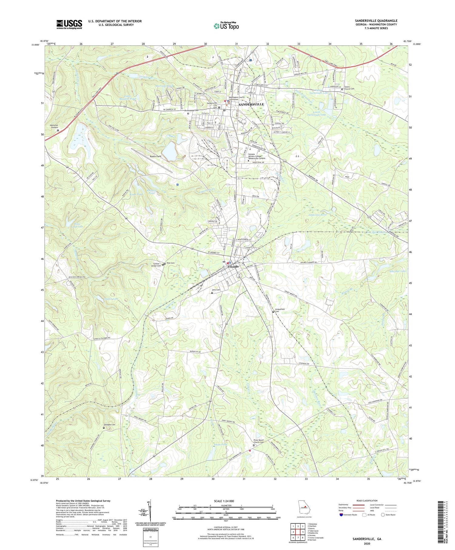
2024 topographic map quadrangle Sandersville in the state of Georgia. Scale: 1:24000. Based on the newly updated USGS 7.5' US Topo map series, this map is in the following counties: Washington. The map contains contour data, water features, and other items you are used to seeing on USGS maps, but also has updated roads and other features. This is the next generation of topographic maps. Printed on high-quality waterproof paper with UV fade-resistant inks.
Quads adjacent to this one:
West: Tabernacle
Northwest: Deepstep
North: Warthen
Northeast: Downs
East: Riddleville
Southeast: Harrison
South: Irwins Crossroads
Southwest: Oconee
This map covers the same area as the classic USGS quad with code o32082h7.
Contains the following named places: Anderson Pond, Brownwood Cemetery, Cedar Meadow Pond, Church-Smith-Harris Streets Historic District, City of Sandersville, City of Tennille, Cold Creek, Crawford School, Dixie Land Lake, Dixie Land Lake Dam, Elder School, First Baptist Church, First Christian Church of Sandersville, First Presbyterian Church, Georgia Grove Church, Grace Episcopal Church, Harrison Pond, Kaolin Field, Kaolin Plaza Shopping Center, Kings Pond, Kings Pond Dam, Limestone Church, Lower Yarbrough Lake, Lower Yarbrough Lake Dam, Marshall Grove Church, Memorial Gardens, Memorial Hospital of Washington County Heliport, North Harris Street Historic District, Ohoopee Cemetery, Ohoopee Church, Ohoopee Volunteer Fire Department, Pete Cemetery, Phillips School, Piney Mount Church, Piney Mount Church Cemetery, Political Pond, Political Pond Dam, Rawlings Sanitarium, Saint Pauls African Methodist Episcopal Church, Saint Williams Roman Catholic Church, Sandersville, Sandersville City Cemetery, Sandersville City Hall, Sandersville Elementary School, Sandersville Fire Department, Sandersville Police Department, Sandersville Post Office, Sandersville United Methodist Church, Segars Pond, Sinquefield Cemetery, Sisters Church, Sisters Church Cemetery, Smith Pond, Smith Pond Dam, Springfield Baptist Church, Sumner - Jordan Cemetery, T J Elder Middle School, Tanyard Branch, Taylor Lake, Taylor Lake Dam, Tennille, Tennille City Hall, Tennille City Park, Tennille Elementary School, Tennille Fire Department, Tennille Police Department, Tennille Post Office, Thiele Kaolin Mining Company Lake, Thiele Kaolin Mining Company Lake Dam, Twin Cities Plaza Shopping Center, Union Hill Church, Upper Yarbrough Lake, Upper Yarbrough Lake Dam, Washington County, Washington County Courthouse, Washington County High School, Washington County Jail, Washington County Regional Medical Center, Washington County Sheriff's Office, Washington Institute, WSNT-AM (Sandersville), WSNT-FM (Sandersville), Zeta Cemetery


