MyTopo
Jerome Idaho US Topo Map
Couldn't load pickup availability
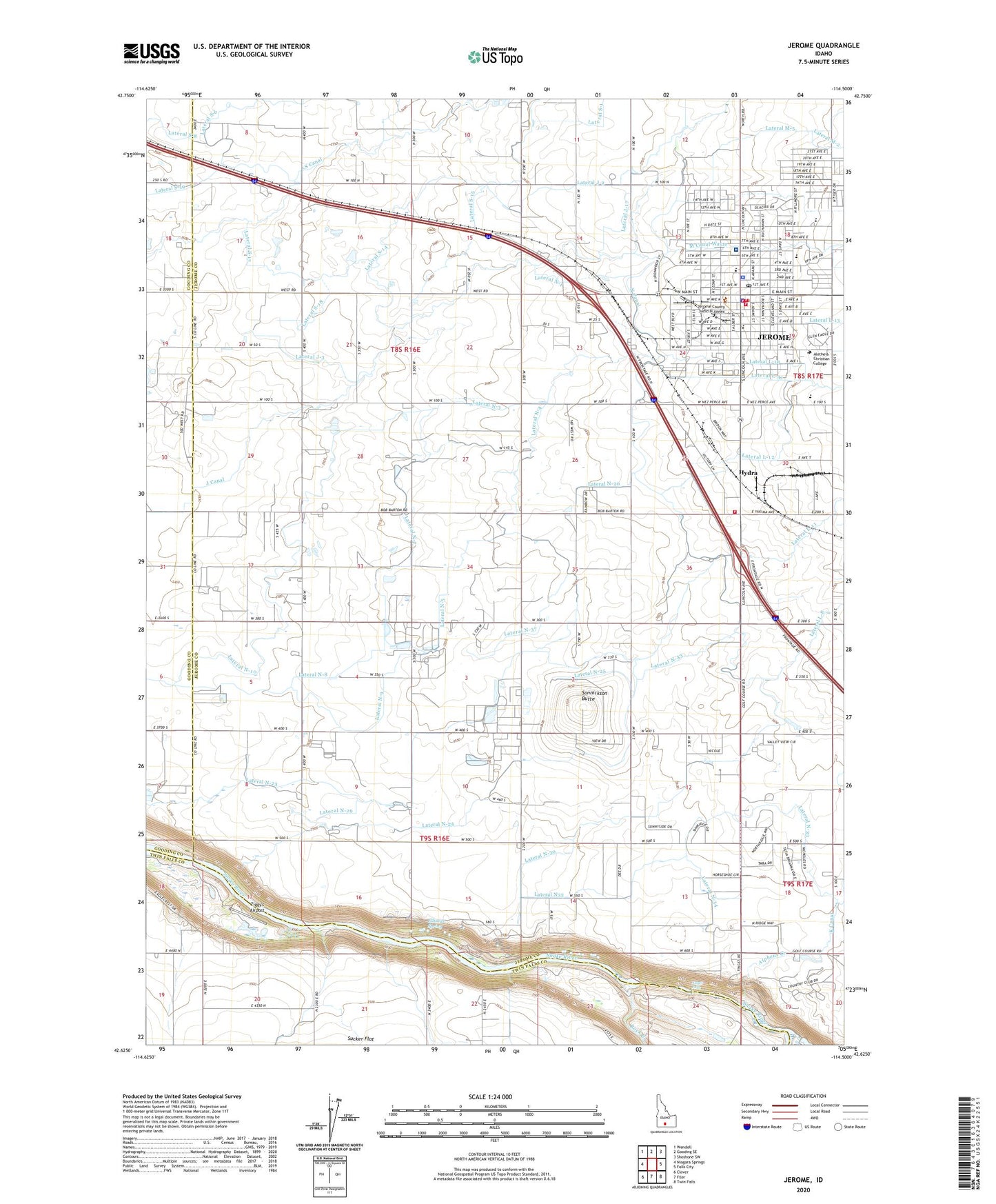
2024 topographic map quadrangle Jerome in the state of Idaho. Scale: 1:24000. Based on the newly updated USGS 7.5' US Topo map series, this map is in the following counties: Jerome, Twin Falls, Gooding. The map contains contour data, water features, and other items you are used to seeing on USGS maps, but also has updated roads and other features. This is the next generation of topographic maps. Printed on high-quality waterproof paper with UV fade-resistant inks.
Quads adjacent to this one:
West: Niagara Springs
Northwest: Wendell
North: Gooding SE
Northeast: Shoshone SW
East: Falls City
Southeast: Twin Falls
South: Filer
Southwest: Clover
This map covers the same area as the classic USGS quad with code o42114f5.
Contains the following named places: Alpheus Creek, Appleton School, Auger Falls, Auger Falls Access Area, Camozzi Park, Candlelight Park, Canyonside Christian School, Central Elementary School, City of Jerome, Ellisons Spring, Gayle Forsyth Memorial Park, Haytown, Hydra, Idaho Department of Fish and Game, Idaho National Guard, Jefferson Elementary School, Jerome, Jerome Cemetery, Jerome City Fire Department Station 1, Jerome City Fire Department Station 2, Jerome City Fire Department Station 3, Jerome City Hall, Jerome City Police Department, Jerome Country Club, Jerome County Courthouse, Jerome County Fairgrounds, Jerome County Historical Museum, Jerome County Paramedics, Jerome County Sheriff's Office, Jerome Early Education Center, Jerome Game Farm, Jerome Middle School, Jerome Post Office, Jerome Rural Fire District, Jerome Station, KART-AM (Jerome), Lateral J-17, Lateral J-2, Lateral J-3, Lateral L-10, Lateral L-11, Lateral L-12, Lateral L-13, Lateral L-14, Lateral L-15, Lateral L-31, Lateral L-34, Lateral L-37, Lateral L-8, Lateral L-9, Lateral M-2, Lateral M-3, Lateral M-4, Lateral M-5, Lateral N-1, Lateral N-15, Lateral N-17, Lateral N-20, Lateral N-22, Lateral N-24, Lateral N-25, Lateral N-29, Lateral N-3, Lateral N-30, Lateral N32, Lateral N-33, Lateral N-34, Lateral N-37, Lateral N-4, Lateral N-41, Lateral N-43, Lateral N-44, Lateral N-45, Lateral N-5, Lateral N-7, Lateral N-8, Lateral N-9, Lateral S-1, Lateral S-14, Lateral S-15, Lateral S-17, Lateral S-18, Lateral S-43, Lateral S-6, M Canal Waste, N Canal, Rock Creek, Saint Luke's Jerome Medical Center, Sonnickson Butte, Warm Creek, Ziggy's Airport