MyTopo
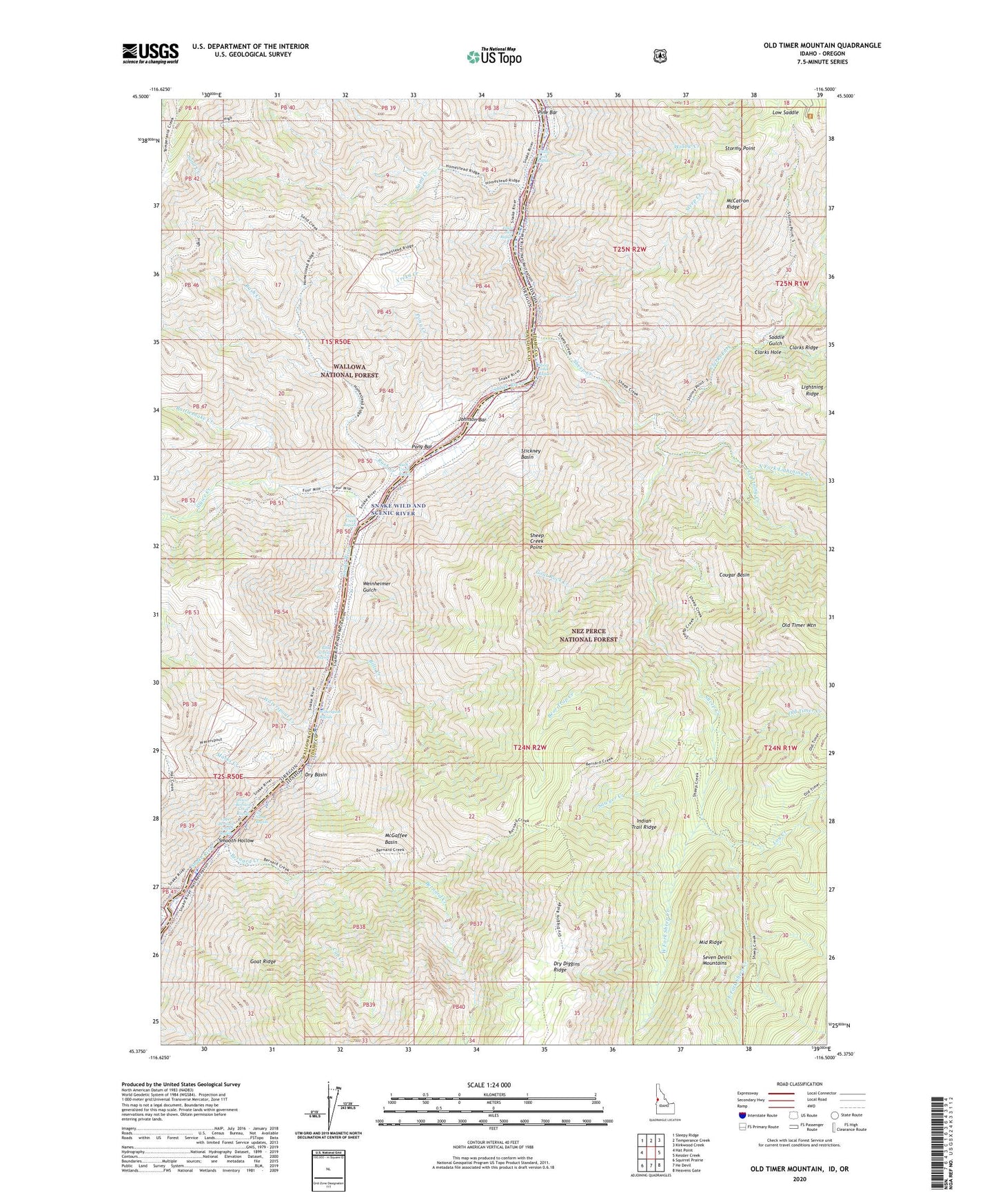
Old Timer Mountain Idaho US Topo Map
Couldn't load pickup availability
Also explore the Old Timer Mountain Forest Service Topo of this same quad for updated USFS data
2024 topographic map quadrangle Old Timer Mountain in the states of Idaho, Oregon. Scale: 1:24000. Based on the newly updated USGS 7.5' US Topo map series, this map is in the following counties: Idaho, Wallowa. The map contains contour data, water features, and other items you are used to seeing on USGS maps, but also has updated roads and other features. This is the next generation of topographic maps. Printed on high-quality waterproof paper with UV fade-resistant inks.
Quads adjacent to this one:
West: Hat Point
Northwest: Sleepy Ridge
North: Temperance Creek
Northeast: Kirkwood Creek
East: Kessler Creek
Southeast: Heavens Gate
South: He Devil
Southwest: Squirrel Prairie
Contains the following named places: Bear Trap Creek, Bernard Creek, Bills Creek, Bills Creek Rapids, Buck Park, Clarks Fork, Clarks Hole, Cougar Basin, Cub Creek, Dry Basin, Eagle Nest Rapids, East Fork Sheep Creek, Goat Ridge, Goat Rock Creek, Hat Creek, Hells Canyon, Hells Canyon Wilderness, Indian Trail Ridge, Johnson Bar, Lightning Creek, Log Creek, Low Saddle, Lower Bernard Creek Rapids, Marks Creek, McCatron Ridge, McGaffee Basin, McGaffee Cabin, McLead Ranch, Middle Fork Clarks Fork, Middle Ridge, No-Name Rapids, North Fork Lightning Creek, Old Timer Creek, Old Timer Mountain, Pine Bar, Pony Bar, Pony Creek, Rattlesnake Creek, Rush Creek, Rush Creek Rapids, Saddle Creek, Saddle Gulch, Sand Creek, Sawyer Creek, Sheep Creek, Sheep Creek Point, Sheep Creek Rapids, Sluice Creek, Sluice Creek Rapids, Smooth Hollow, Steep Creek, Stickney Basin, Stickney Garden, Stormy Point, Upper Bernard Creek Rapids, Waterspout Creek, Waterspout Rapids, Weinheimer Gulch, West Fork Sheep Creek, Willow Creek, Willow Creek Rapids, Wilson, Wilson Cabin, Wilson Cow Camp, Yreka Creek