
MyTopo
Payette Idaho US Topo Map
Couldn't load pickup availability
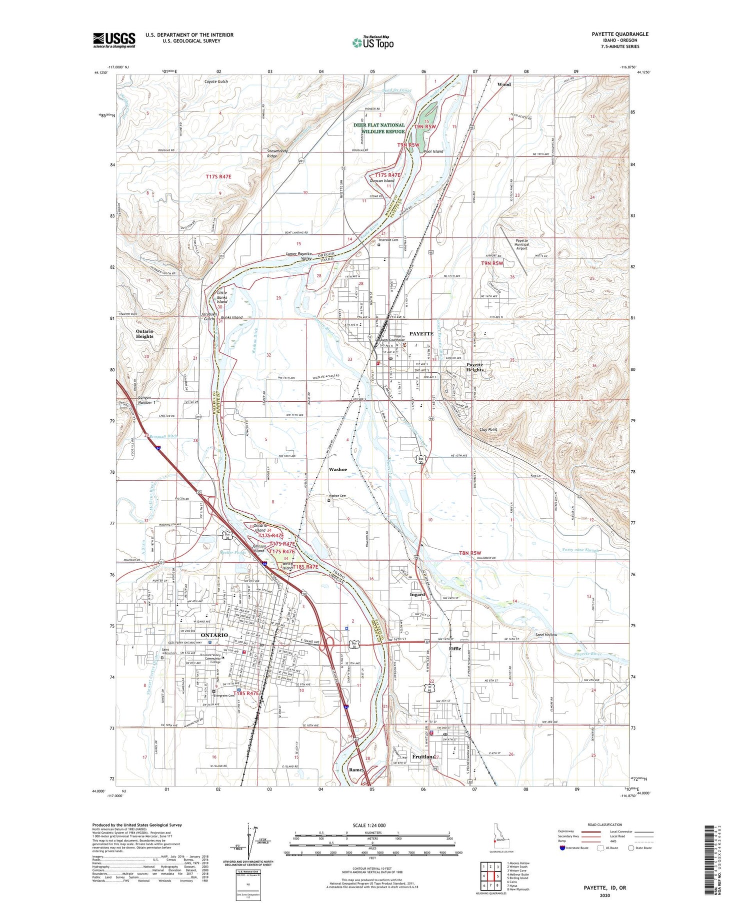
2024 topographic map quadrangle Payette in the states of Idaho, Oregon. Scale: 1:24000. Based on the newly updated USGS 7.5' US Topo map series, this map is in the following counties: Payette, Malheur. The map contains contour data, water features, and other items you are used to seeing on USGS maps, but also has updated roads and other features. This is the next generation of topographic maps. Printed on high-quality waterproof paper with UV fade-resistant inks.
Quads adjacent to this one:
West: Malheur Butte
Northwest: Moores Hollow
North: Weiser South
Northeast: Weiser Cove
East: Birding Island
Southeast: New Plymouth
South: Nyssa
Southwest: Cairo
Contains the following named places: 4 D J Farm, Aiken Elementary School, Alameda Elementary School, Banks Island, Becker Ponds, Beck-Kiwanis Park, Canyon Number 1, Central Park, City of Fruitland, City of Ontario, City of Payette, Clay Point, Dead Ox Canal, Department of Motor Vehicles Ontario, Duncan Island, Eastside Park, Eastside Primary School, Eiffie, Evergreen Cemetery, Farmers Ditch, Forty-nine Slough, Foundations Services Center, Four Rivers Cultural Center and Museum, Four Rivers Cultural Center and Museum Convention Center, Four Rivers Cultural Center and Museum Meyer McLean Theater, Fruitland, Fruitland City Police Department, Fruitland Elementary School, Fruitland Fire Department, Fruitland High School, Fruitland Middle School, Fruitland Post Office, Gayway Corner, Greyhound Bus Station Ontario, Holy Rosary Medical Center Heliport, Ingard, Jacobsen Gulch, Johnson Island, KIOV-AM (Payette), Kiwanis Park, KQXR-FM (Payette), KSRV - AM, Laxson Park, Lindbergh School, Lions Park, Little Banks Island, Little Banks Island Wildlife Habitat Area, Lower Ditch, Malheur County Alcohol and Drug Recovery Center, Malheur County Fairgrounds, Malheur County Health Department Office, Malheur County Justice Court, Malheur River, May Roberts Elementary School, McCain Middle School, Ontario, Ontario City Hall, Ontario City Police Department, Ontario Community Library, Ontario Fire and Rescue, Ontario High School, Ontario Island, Ontario Middle School, Ontario Municipal Court, Ontario Post Office, Ontario Public Works Department, Ontario Safety Rest Area, Ontario State Park, Ontario State Park Boat Ramp, Ontario Wastewater Treatment Plant, Ontario Water Treatment Plant, Orchard Ave Grange Hall, Oregon State Police Department Ontario Area Command, Payette, Payette City and Rural Fire Department, Payette County Paramedics, Payette County Sheriff's Office, Payette Heights, Payette High School, Payette Junction, Payette Municipal Airport, Payette Police Department, Payette Post Office, Payette Primary School, Payette River, Pioneer Elementary School, Pool Island, Ramey, River of Life Christian School, Riverside Cemetery, Rosedale Memorial Park, Saint Alphonsus Medical Center, Saint Johns Cemetery, Saint Peter Catholic School, Sand Hollow, Snowmoody Ridge, SRV Coop Snap Building, Stewart Carter Ditch, Treasure Valley Ball Park, Treasure Valley Christian School, Treasure Valley Community College, Treasure Valley Seventh-Day Adventist, Vernie Post Office, Washoe, Washoe Cemetery, Washoe Ditch, Welch Island, Westside Elementary School


