MyTopo
Gillespie South Illinois US Topo Map
Couldn't load pickup availability
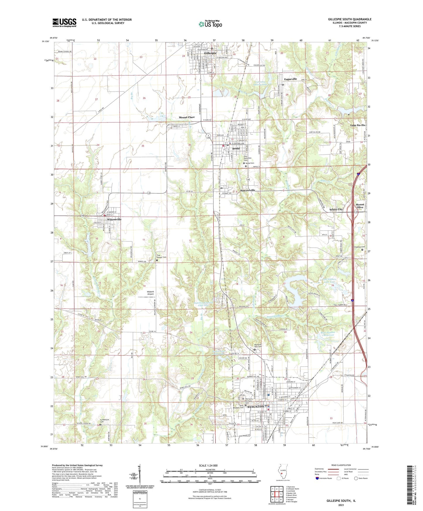
2024 topographic map quadrangle Gillespie South in the state of Illinois. Scale: 1:24000. Based on the newly updated USGS 7.5' US Topo map series, this map is in the following counties: Macoupin. The map contains contour data, water features, and other items you are used to seeing on USGS maps, but also has updated roads and other features. This is the next generation of topographic maps. Printed on high-quality waterproof paper with UV fade-resistant inks.
Quads adjacent to this one:
West: Bunker Hill
Northwest: Plainview
North: Gillespie North
Northeast: Litchfield
East: Mount Olive
Southeast: New Douglas
South: Worden
Southwest: Prairietown
This map covers the same area as the classic USGS quad with code o39089a7.
Contains the following named places: Bear Creek, Benld, Benld Cemetery, Benld City Hall, Benld Elementary School, Benld Police Department, Benld Post Office, Benld Volunteer Fire Department, Big Branch, Chapman Cemetery, City of Benld, City of Staunton, Columbia Quarry Lake, Columbia Quarry Lake Dam, Community Memorial Hospital Heliport, Community Memorial Hospital of Staunton, Country View Nursing Home, Eagarville Post Office, Eagerville, East Creek, East School, Elmwood School, First Baptist Church, First General Baptist Church, First United Baptist Church, First United Methodist Church, Forest Lake Club Dam, Forest Lake Club Lake, Funderburk Cemetery, Gillespie - Benld Area Ambulance Service, Gillespie City Cemetery, Ginseng Creek, Holy Dormition Cemetery, Isaac School, Lower Springdale School, Memorial Park Cemetery, Mine Number 1, Mine Number 14, Mine Number 15, Mine Number 2, Mine Number 3, Mine Number 4, Mine Number 7, Mine Number 7 Reservoir, Mount Clare, Mount Olive City Lake Dam, Mount Olive Lake, North Bend School, North Fifth Street Baptist Church, Old Saint Michaels Cemetery, Panther Creek, Pleasant Ridge School, Saint Joseph Roman Catholic Church, Saint Marias Church, Saint Michael School, Saint Michaels Catholic Church, Saint Michaels Cemetery, Saint Pauls United Church of Christ, Sawyerville, Sawyerville Post Office, Sawyerville Public School, Shady Oak Park, Smutzlar Siding, South School, Spring Creek, Staunton, Staunton Area Ambulance Service, Staunton City Hall, Staunton Country Club, Staunton Country Club Lake, Staunton Country Club Lake Dam, Staunton Fire Protection District, Staunton High School, Staunton Police Department, Staunton Post Office, Staunton Reservoir, Staunton Reservoir Dam, Sugar Camp Creek, Sugar Creek, Tall Timbers Lake East, Tall Timbers Lake East Dam, Tall Timbers Lake West, Tall Timbers Lake West Dam, Tine Sawyer Cemetery, Township of Dorchester, Township of Mount Olive, Township of Staunton, Upper Springdale School, VFW Park, Village of Eagarville, Village of Mount Clare, Village of Sawyerville, Village of White City, Village of Wilsonville, Walls Siding, White City, Willhoit Airport, Wilsonville, Wilsonville Post Office, Wilsonville Volunteer Fire Department, Zion Lutheran Church, Zion Lutheran School, ZIP Codes: 62009, 62023, 62085, 62088, 62093