MyTopo
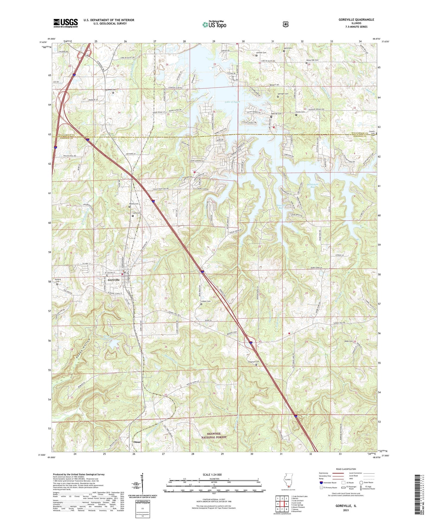
Goreville Illinois US Topo Map
Couldn't load pickup availability
Also explore the Goreville Forest Service Topo of this same quad for updated USFS data
2024 topographic map quadrangle Goreville in the state of Illinois. Scale: 1:24000. Based on the newly updated USGS 7.5' US Topo map series, this map is in the following counties: Johnson, Williamson. The map contains contour data, water features, and other items you are used to seeing on USGS maps, but also has updated roads and other features. This is the next generation of topographic maps. Printed on high-quality waterproof paper with UV fade-resistant inks.
Quads adjacent to this one:
West: Lick Creek
Northwest: Crab Orchard Lake
North: Marion
Northeast: Crab Orchard
East: Creal Springs
Southeast: Bloomfield
South: Vienna
Southwest: Mount Pleasant
This map covers the same area as the classic USGS quad with code o37088e8.
Contains the following named places: Anderson Creek, Beaver Creek, Bethlehem Bay, Bethlehem Church, Buck Ridge Campground, Burklow School, Busby Church, Cana Cemetery, Caney School, Cedar Hills, Chapman Cemetery, Christadelphia Church, Church of Christ, Clifty Creek, Clifty Heights, Cocke Cemetery, County Line Cemetery, Crestwood, Deer Ridge, Dry Fork Creek, Dunntown School, Eagle Point Bay, Egypt Shores, Egyptian Acres, Egyptian Hills, Farmers Bluff Church, Ferne Clyffe Dam, Ferne Clyffe Lake, Ferne Clyffe State Park, First Baptist Church of Goreville, Fopal, Fox Point Picnic Area, Friendship Church, Gibson Cemetery, Goodhope School, Goreville, Goreville Apostolic Church, Goreville Elementary School, Goreville High School, Goreville Number 2 Election Precinct, Goreville Police Department, Goreville Post Office, Goreville United Methodist Church, Goreville Volunteer Fire Department, Hickory Grove Church, Howard Cemetery, Kelleys, Kimmel Cemetery, Lake Crest, Lake Egypt Fire Protection District Headquarters, Lake Egypt Fire Protection District Station 2, Lake Egypt Fire Protection District Station 3, Lake Estates, Lake Number 1 Election Precinct, Lake of Egypt, McBride Cemetery, McKinney Chapel, Meneese Cemetery, Menes School, Mosley Cemetery, North Shoreline, Omar, Parrish Ridge School, Pharoahs Gardens, Pulleys Mill, Pulleys Mill Pentecostal Church, Robinwood, Round Bluff Nature Preserve, Shawnee Bay, Sleepy Hollow, Springer Cemetery, Sugar Creek, Sugar Creek Ranch, Sunset Harbor, Township of Goreville, Township of Tunnel Hill, Tunnel Hill Election Precinct, Village of Goreville, Wagon Creek Heaven, Walkerville School, Ward Cemetery, Webb Cemetery, Webbtown Church, Wesley Chapel, White Oak Cemetery, Whiteoak School, Woodland Hills, ZIP Code: 62939