MyTopo
La Salle Illinois US Topo Map
Couldn't load pickup availability
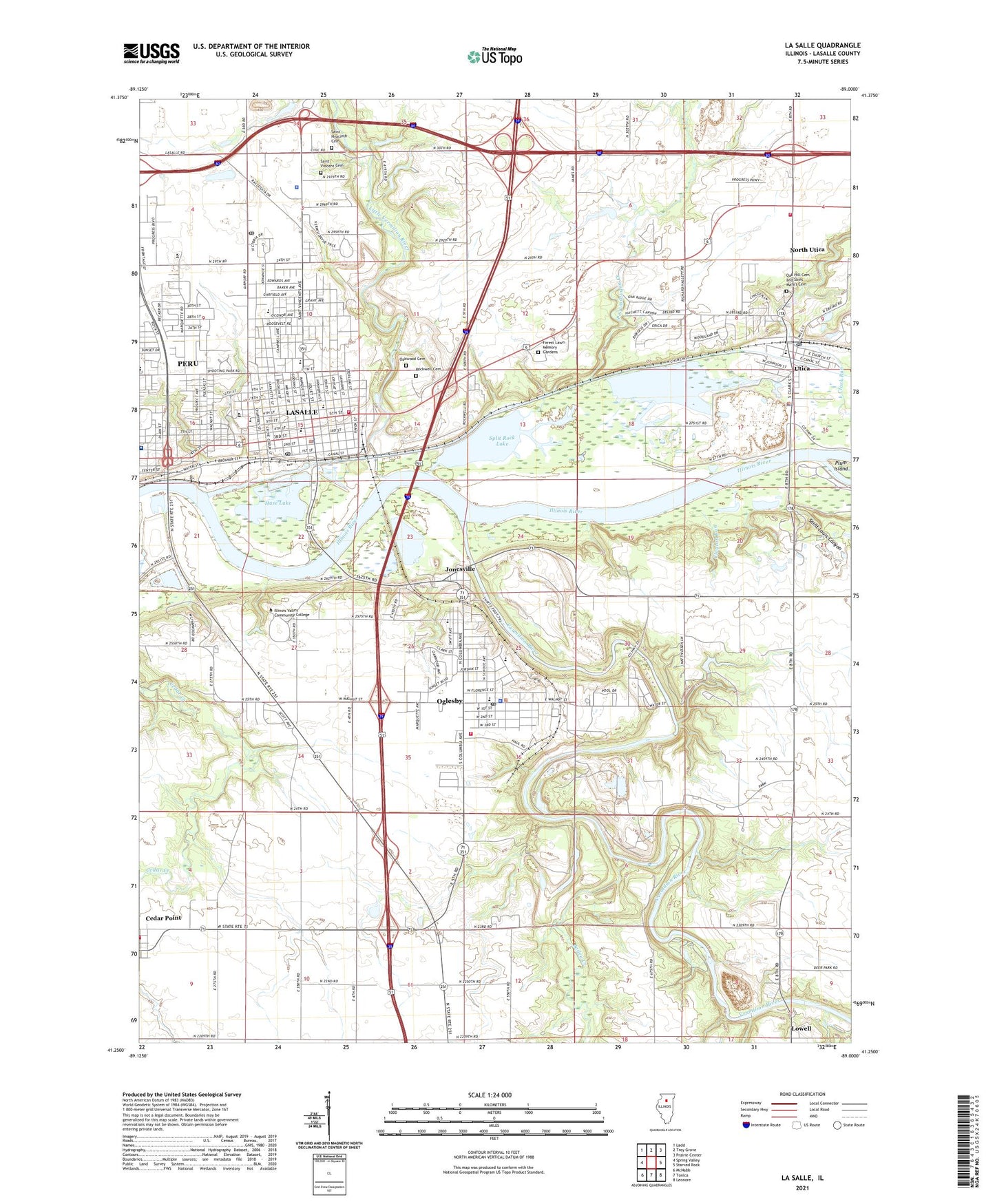
2024 topographic map quadrangle La Salle in the state of Illinois. Scale: 1:24000. Based on the newly updated USGS 7.5' US Topo map series, this map is in the following counties: LaSalle. The map contains contour data, water features, and other items you are used to seeing on USGS maps, but also has updated roads and other features. This is the next generation of topographic maps. Printed on high-quality waterproof paper with UV fade-resistant inks.
Quads adjacent to this one:
West: Spring Valley
Northwest: Ladd
North: Troy Grove
Northeast: Prairie Center
East: Starved Rock
Southeast: Leonore
South: Tonica
Southwest: McNabb
This map covers the same area as the classic USGS quad with code o41089c1.
Contains the following named places: Bailey Creek, Bailey Falls, Baker Park, Bassett Airport, Carey Memorial Park, Cedar Point Fire Department, Cerri Memorial Park, Christ Family Foursquare Church, Church of God, Church of the Resurrection, City of LaSalle, City of Oglesby, City of Peru Wastewater Treatment Plant, Clareknoll Novitiate, Clayton Run, Deer Park, Deer Park Country Club, Deer Park Lake, Deer Park Lake Dam, Deer Park Station, Dickinson House Community Building, Downtown La Salle Post Office, First Baptist Church, First Congregational Church, Forest Lawn Memory Gardens, Grace Church, Hegeler Park, Holy Family School, Huse Lake, Illinois State Police Department District 17, Illinois Valley Community College, Illinois Valley Community Hospital, Illinois Valley Community Hospital Heliport, Jackson Elementary School, Jefferson School, Jonesville, La Salle, La Salle City Building, La Salle Police Department, La Salle Post Office, La Salle Speedway, La Salle-Peru Township High School, LaSalle Fire Department, Lasalle-Peru-Oglesby Junior College, Lehigh Memorial Park, Lincoln Elementary School, Lincoln Junior High School, Little Rock, Little Vermilion River, Lowell, Margery C Carlson Nature Preserve, Market Square, Mary Hegeler Carus Park, Mattheissen Park, Matthiessen Dells Nature Preserve, Matthiessen School, Matthiessen State Park, McKinley Park, Northview Elementary School, Northwest Elementary School, Oak Hill Cemetery and Saint Mary's Cemetery, Oakwood Cemetery, Oglesby, Oglesby City Hall, Oglesby Fire Protection District, Oglesby Police Department, Oglesby Post Office, Oglesby Public Library, Oglesby Union Church, Oglesby Volunteer Ambulance Service, Pecumsaugan Creek, Pecumsaugan Creek - Blackball Mines Nature Preserve, Peru Public Library, Peru Volunteer Ambulance Service, Peru Washington School, Piety Hill, Pulaski Park, Queen of the Holy Rosary Roman Catholic Church, Rockwell Cemetery, Sacred Heart Roman Catholic Church, Saint Hyacinth Cemetery, Saint Hyacinth School, Saint Hyacinths Roman Catholic Church, Saint Louis Canyon, Saint Marys Hospital, Saint Marys Park, Saint Mary's Parochial School, Saint Marys Roman Catholic Church, Saint Patricks Roman Catholic Church, Saint Pauls Episcopal Church, Saint Roch School, Saint Valentine Church, Saint Valentine's School, Saint Vincent Cemetery, South Bluff Country Club, Split Rock Lake, Starved Rock Nature Preserve, Temple B'nai Moshe, Township of LaSalle, Trinity United Church of Christ, Trovero Airport, Utica, Utica Community Fire Protection District, Utica Elementary School, Utica Pit, Utica Police Department, Vermilion Quarry, Vermilion River, Village of North Utica, Washington Elementary School, Washington Park, Washington School, WLPO-AM (La Salle), WLRZ-FM (Peru), ZIP Codes: 61316, 61348