MyTopo
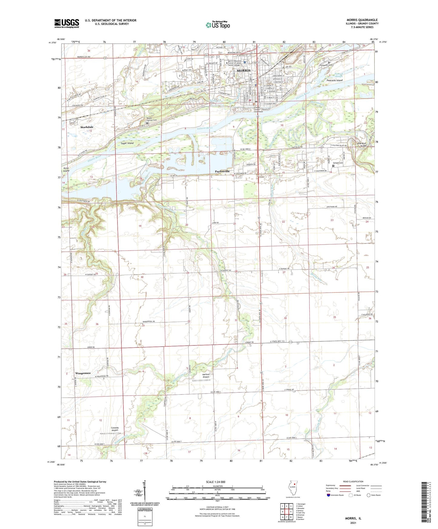
Morris Illinois US Topo Map
Couldn't load pickup availability
2024 topographic map quadrangle Morris in the state of Illinois. Scale: 1:24000. Based on the newly updated USGS 7.5' US Topo map series, this map is in the following counties: Grundy. The map contains contour data, water features, and other items you are used to seeing on USGS maps, but also has updated roads and other features. This is the next generation of topographic maps. Printed on high-quality waterproof paper with UV fade-resistant inks.
Quads adjacent to this one:
West: Seneca
Northwest: Stavanger
North: Lisbon
Northeast: Minooka
East: Coal City
Southeast: Gardner
South: Mazon
Southwest: Kinsman
This map covers the same area as the classic USGS quad with code o41088c4.
Contains the following named places: Bethlehem Lutheran Church, Bills Run, Burleigh School, Center Elementary School, Chapin Park, Church of Christ, City of Morris, Claypool, Claypool School, Claypool Woods, Curanda Airport, East Fork Nettle Creek, Evergreen Cemetery, First Baptist Church, First Church of the Nazarene, First Presbyterian Church, First United Methodist Church, Franklin School, Garfield Elementary School, Gaslight Village, Gebhard Woods State Park, Gibson School, Goold Park, Gorham School, Grundy County, Grundy County Courthouse, Grundy County Farm, Grundy County Sheriff's Office, Harford Airport, Haymond School, Heatherfield, Hoge School, Hume School, Illinois and Michigan Canal National Heritage Corridor, Immaculate Conception Catholic Church, Immaculate Conception School, Mazon River, Morris, Morris City Hall, Morris City Landfill, Morris Fire Protection and Ambulance District Fire Station 1, Morris Healthcare Rehabilitation Center, Morris High School, Morris Hospital and Healthcare Center, Morris Hospital Heliport, Morris Police Department, Morris Post Office, Mount Carmel Cemetery, Mud Slough, Nettle Creek, Nettle Creek Aqueduct, New Hope Lutheran Church, Opdyke School, Our Saviors Church, Paytonville, Peace Chapel Assembly of God Church, Peacock Slough, Peacocks Island, Pebble Beach, Pine Bluff Bridge, Pine Grove, Pine Meadow Estates, Plum School, Richards Park, Saint Angela School, Saint Thomas Episcopal Church, Sample Cemetery, Shabbona Middle School, Spring Run, Stein School, Stockdale, Sugar Island, Thum School, Township of Morris, Township of Wauponsee, Waupecan Creek, Wauponsee, WCFL-FM (Morris), WCSJ-AM (Morris), William Stratton State Access Area, Willow Ridge, ZIP Code: 60450