MyTopo
Quincy East Illinois US Topo Map
Couldn't load pickup availability
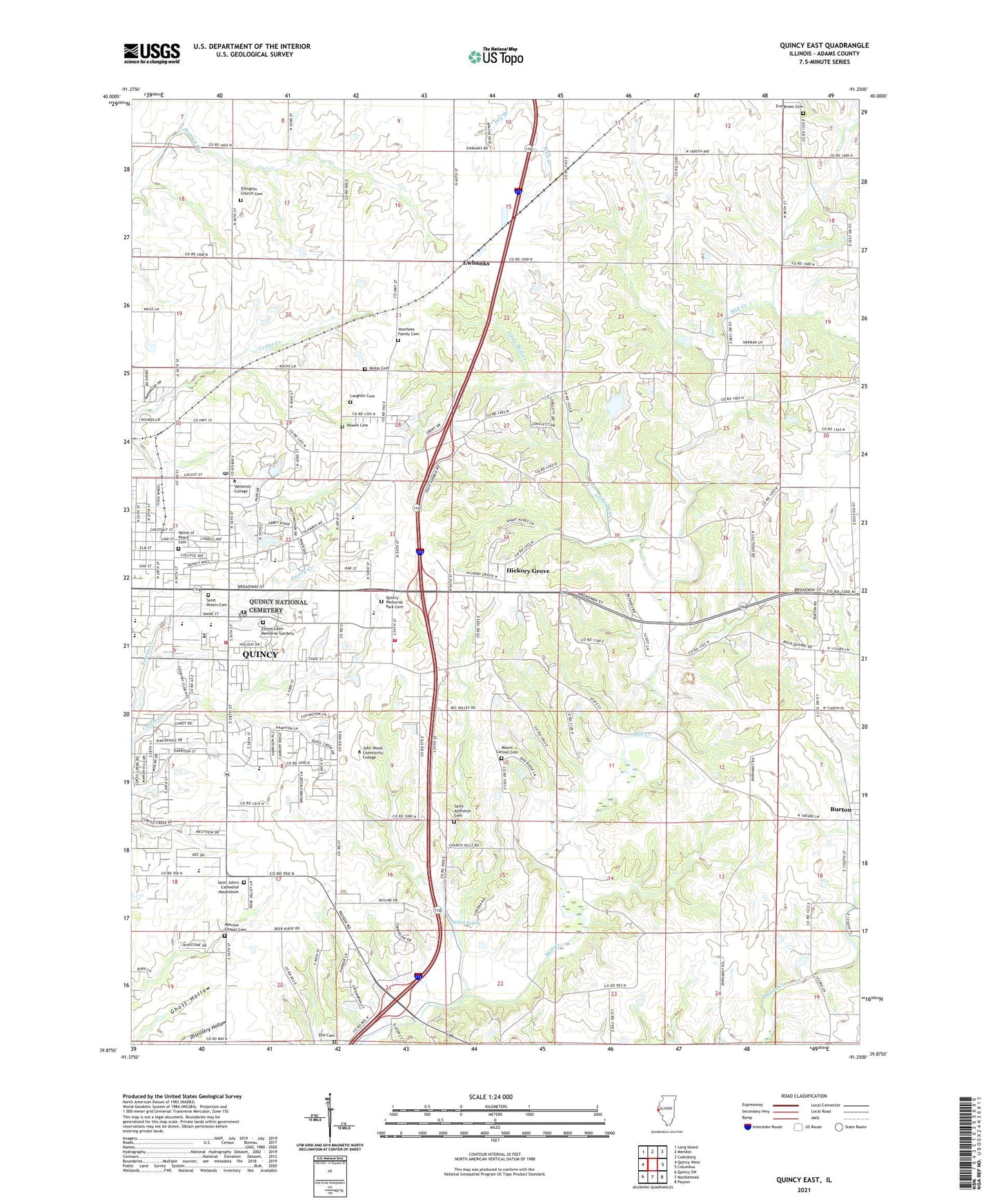
2024 topographic map quadrangle Quincy East in the state of Illinois. Scale: 1:24000. Based on the newly updated USGS 7.5' US Topo map series, this map is in the following counties: Adams. The map contains contour data, water features, and other items you are used to seeing on USGS maps, but also has updated roads and other features. This is the next generation of topographic maps. Printed on high-quality waterproof paper with UV fade-resistant inks.
Quads adjacent to this one:
West: Quincy West
Northwest: Long Island
North: Mendon
Northeast: Coatsburg
East: Columbus
Southeast: Payson
South: Marblehead
Southwest: Quincy SW
This map covers the same area as the classic USGS quad with code o39091h3.
Contains the following named places: Adams County Youth Home, Cedar Creek Country Club, Center School, Chaddock School, Cheshire Hills, Christ Lutheran Church, Cliola Post Office, Columbus Road Baptist Church, Country Meadows, Edgewood Orchards, Ehe Cemetery, Ellington Church Cemetery, Ellington Elementary School, Ellington Field, Ellington Memorial Presbyterian Church, Ellington Townhall, Emery Creek, Evergreen Cemetery, Ewbanks, Fairview Dairy, Forest Lawn Memorial Gardens, Franklin School, Glendale, Graceland Cemetery, Hickory Grove, Hickory Grove School, Hillside Manor, Holiday Hills, John Wood Community College, Kemp Cemetery, Laughlin Cemetery, Lincoln Hills, Lincoln School, Little Mill Creek, Mast Field, Meadowbrook, Melrose Chapel Cemetery, Melrose Chapel United Methodist Church, Melrose School, Mill Creek Farm, Mill Creek Quarry, Monroe Elementary School, Mount Carmel Cemetery, Mount Carmel School, Our Redeemer Lutheran Church, Powell Cemetery, Progress Park, Quincy Commons Shopping Center, Quincy Country Club, Quincy Fire Department Station 3, Quincy Mall Shopping Center, Quincy Memorial Park Cemetery, Quincy Municipal Golf Course, Quincy National Cemetery, Quincy Post Office, Quincy Senior High School, Saint Anthony Roman Catholic Church, Saint Anthonys Cemetery, Saint Anthonys School, Saint Dominic School, Saint John Lutheran Church, Saint Ludgerus School, Saint Peters Cemetery, Saint Peters Roman Catholic Church, Saint Peters School, Seigfried Halfpap Airport, Township of Ellington, Township of Melrose, Tri - Township Fire Protection District, Tuthill Farm, Union School, Valley of Peace Cemetery, Voorhees Family Cemetery, Wand Spring, Washington School, Waters School, Wavering Park, Westview Park, WGCA-FM (Quincy), WGEM-AM (Quincy), WGEM-FM (Quincy), WGEM-TV (Quincy), Whiteoak School, Woodlawn Court, WQCY-FM (Quincy), WQEC-TV (Quincy), WTJR-TV (Quincy), WWQC-FM (Quincy), WZLZ-FM (Quincy), ZIP Code: 62305