MyTopo
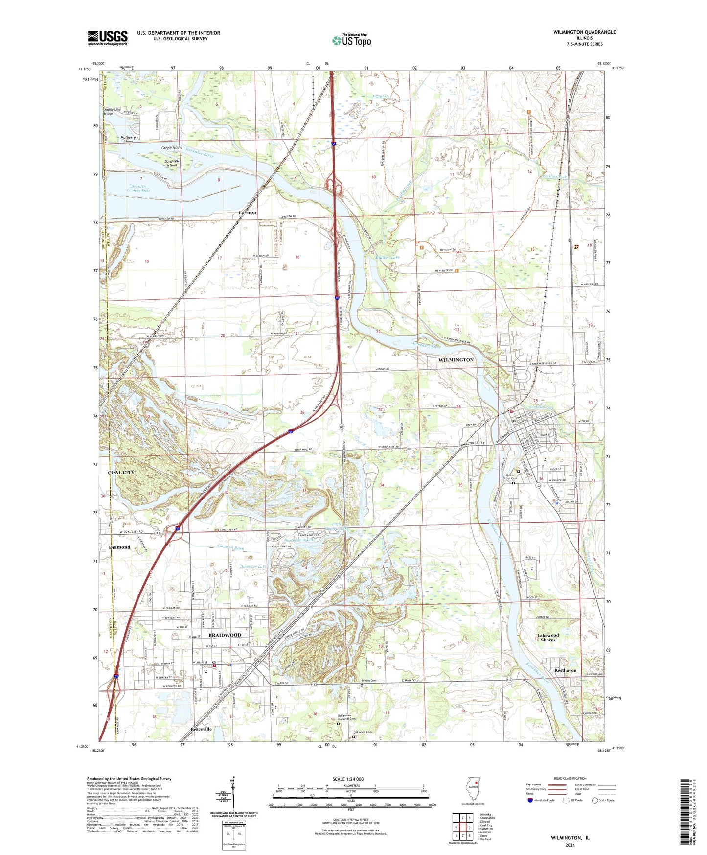
Wilmington Illinois US Topo Map
Couldn't load pickup availability
Also explore the Wilmington Forest Service Topo of this same quad for updated USFS data
2024 topographic map quadrangle Wilmington in the state of Illinois. Scale: 1:24000. Based on the newly updated USGS 7.5' US Topo map series, this map is in the following counties: Will, Grundy. The map contains contour data, water features, and other items you are used to seeing on USGS maps, but also has updated roads and other features. This is the next generation of topographic maps. Printed on high-quality waterproof paper with UV fade-resistant inks.
Quads adjacent to this one:
West: Coal City
Northwest: Minooka
North: Channahon
Northeast: Elwood
East: Symerton
Southeast: Bonfield
South: Essex
Southwest: Gardner
This map covers the same area as the classic USGS quad with code o41088c2.
Contains the following named places: A Mine, Bardwell Island, Bardwell Mine, Big Shadow Lake, Bohemian National Cemetery, Booth Central Elementary School, Braidwood, Braidwood City Park, Braidwood Dunes and Savanna Nature Preserve, Braidwood Elementary School, Braidwood Fire Protection District Station 1, Braidwood Police Department, Braidwood Post Office, Brookside School, Bruning Elementary School, C Mine, Christian Life Church, Church of Christ, Church of God, Cinder Ridge Golf Links, City of Braidwood, City of Wilmington, Co-Operative Mine, County Line Bridge, Custer Park Baptist Church, D Mine, Des Plaines Game Farm, Dinosaur Lake, Dresden Cooling Lake, Dwyer School, E Mine, Eureka Number 1 Mine, Eureka Number 2 Mine, F Mine, First Apostolic Church, First Baptist Church, First Christian Church, First Presbyterian Church, First United Methodist Church, Forked Creek, Forsythe Woods County Forest Preserve, G Mine, Grace Lutheran Church, Grant Creek Prairie Nature Preserve, Grape Island, Haskett Mine, Hawk Lake, Hitts Siding, Hitts Siding Prairie Nature Preserve, Hunter Mine, I Mine, Immaculate Conception Church, Island Park, J Mine, Johnson School, Joliet Ammunitions Plant, Jordan Creek, Kankakee Bridge Station, Keeversville School, L J Stevens Middle School, L Mine, Lakewood Shores, Lakewood Shores Census Designated Place, Little Shadow Lake, Lorenzo, Lorenzo Census Designated Place, Main Street Baptist Church, Mather, Matlby Mine, Milliken Lake, Moulton School, Mount Olivet Cemetery, Mulberry Island, Murphy Linskey And Kasher Number 4 Mine, Murphy And Keenan Number 3 Mine, N Mine, Northcrest School, O Mine, Oakwood Cemetery, Oakwood Protestant Cemetery, Oswald And Young Mine, Pit 1 Northern Mine, Pit 1A Northern Mine, Pit 1B Northern Mine, Pit 1C Northern Mine, Pit 2 Northern Mine, Pit 3 Northern Mine, Pit 4 Northern Mine, Pit 5 Northern Mine, Prairie Creek, Prairie Creek School, Reed-Custer High School, Rest Haven Census Designated Place, Resthaven, Riverwood Estates, Saint Rose Church, Saint Rose School, Sand Ridge Savanna Nature Preserve, Schoonmaker Mine, Silver Oaks Golf Club, Skinner Number 2 Mine, Soldiers Widows Home, Spillway 531, Third Shadow Lake, Tierney School, Township of Wilmington, WDND-FM (Wilmington), Webster Siding, Will Mine, Wilmington, Wilmington Church of the Nazarene, Wilmington City Hall, Wilmington Fire Protection District, Wilmington High School, Wilmington Mine, Wilmington Number 2 Mine, Wilmington Police Department, Wilmington Post Office, Wilmington Shrub Prairie Nature Preserve, Winchester Estates, WKBM-FM (Coal City), ZIP Code: 60408