MyTopo
Bargersville Indiana US Topo Map
Couldn't load pickup availability
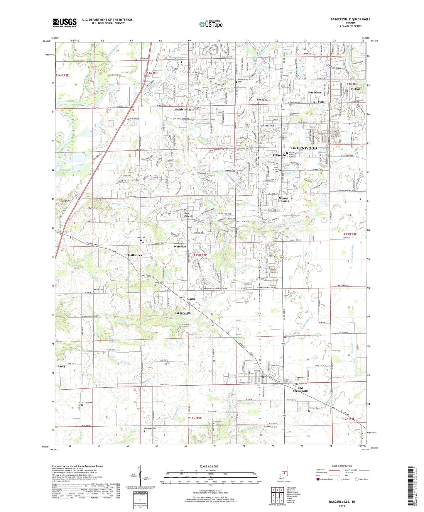
2022 topographic map quadrangle Bargersville in the state of Indiana. Scale: 1:24000. Based on the newly updated USGS 7.5' US Topo map series, this map is in the following counties: Johnson, Morgan. The map contains contour data, water features, and other items you are used to seeing on USGS maps, but also has updated roads and other features. This is the next generation of topographic maps. Printed on high-quality waterproof paper with UV fade-resistant inks.
Quads adjacent to this one:
West: Mooresville East
Northwest: Bridgeport
North: Maywood
Northeast: Beech Grove
East: Greenwood
Southeast: Franklin
South: Trafalgar
Southwest: Cope
This map covers the same area as the classic USGS quad with code o39086e2.
Contains the following named places: Alexander Ditch, Al-Mar, Auburn Branch, Auburn Trace, Bargersvill Police Department, Bargersville, Bargersville Cemetery, Bargersville Christian Church, Bargersville Community Fire Department Station 1, Bargersville Community Fire Department Station 2, Bargersville Community Fire Station 1, Bargersville Community Fire Station 2, Bargersville Post Office, Beck Airport, Bluff Acres, Bluff Creek, Bluff Creek Christian Church, Boles Cemetery, Brentridge, Brentwood, Brockton Manor, Cedar Hills, Center Creek, Center Grove High School, Clearview, Critchfield, Crook Branch, Deerwood, Doty Run, Doty Run Lake Dam, Eagle Trace, El Dorado, Elmer C Summit Lake Dam, Fair Brook, Fairview Creek, Forest Lawn Memory Gardens, Foxberry Trace, Frances, Frances Creek, Gilmore Cemetery, Gilmore Creek, Golden Grove, Green Valley, Greenwood Fire Department Station 93, Greenwood Nursing Home, Henderson Cemetery, Hendricks, Hickory Stick Golf Club, Honey Creek, Honey Creek Church, Horizon Estates, Hunters Pointe, Kinder, Kinder Run, Lake Run, Lowe Cemetery, Lowe Creek, Mallow Cemetery, Mallow Run, McCarty, McColgin Cemetery, McColgin Creek, Meridian Place Shopping Center, Messersmith Cemetery, Messersmith Creek, Miles Field Airport, Miller Cemetery, Mount Auburn Cemetery, Mount Auburn United Methodist Church, Mount Pleasant Christian Church, Old Bargersville, Pebble Hills, Pebble Run, Pennington Estates, Pleasant Run Creek, Roberts Ditch, Royal Oak Country Club, Salem Brook, Salem Cemetery, Salem Church, Sally Doty Hill, Scott Ditch, Smith Run, Smith Valley, Smith Valley Baptist Church, Stones Crossing, The Centre At Smith Valley Shopping Center, Thorn Field, Town of Bargersville, Township of White River, Travis Creek, Travis Hill, Tremont, Turkey Pen Creek, Utterback Branch, Utterback Cemetery, Walnut Ridge Golf Course, Waterloo, Waterloo Run, Waters Edge, White River Township Fire Department Station 51, White River Township Fire Department Station 52, White River Township Fire Department Station 53, Willow Lakes, Woodland Stream, ZIP Codes: 46106, 46142