MyTopo
Bridgeport Indiana US Topo Map
Couldn't load pickup availability
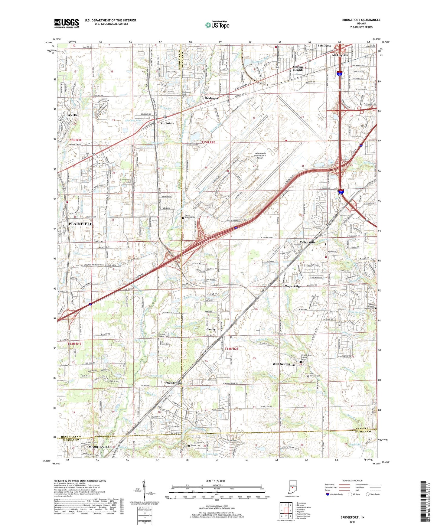
2022 topographic map quadrangle Bridgeport in the state of Indiana. Scale: 1:24000. Based on the newly updated USGS 7.5' US Topo map series, this map is in the following counties: Marion, Hendricks, Morgan. The map contains contour data, water features, and other items you are used to seeing on USGS maps, but also has updated roads and other features. This is the next generation of topographic maps. Printed on high-quality waterproof paper with UV fade-resistant inks.
Quads adjacent to this one:
West: Plainfield
Northwest: Brownsburg
North: Clermont
Northeast: Indianapolis West
East: Maywood
Southeast: Bargersville
South: Mooresville East
Southwest: Mooresville West
This map covers the same area as the classic USGS quad with code o39086f3.
Contains the following named places: Airport Business Center, Aldersgate Church, Ameriplex Business Park, Army Branch, Avon Creek, Ayr-Way Washington West Shopping Center, Ben Davis, Ben Davis Station, Bethel Cemetery Indianapolis Airport, Bethel Church, Black Creek, Bluff Creek, Bridge Creek, Bridgeport, Bridgeport Cemetery, Bridgeport Nazarene Church, Cam Branch, Camby, Camby Creek, Camby Post Office, Carson Park, Center Church, Center Creek, Center Friends Cemetery, Central Bridgeport Baptist Church, Central Park, Church by the Side of the Road, Davis Creek, Dead Run, Decatur Branch Indianapolis-Marion County Public Library, Decatur Central High School, Decatur Township Fire Department Station 72, Decatur Township Fire Station 773, Decatur Township Junior High School, Decatur Township Volunteer Fire Department Station 71, Fair Creek, Fairfield Church, Fairfield Friends Cemetery, First Baptist Church, Fletcher Business Park, Flynn Creek, Friends Creek, Friendswood, Friendswood Baptist Church, Friendswood Golf Course, George Creek, Good Shepherd Baptist Church, Grace On Wings Air Ambulance, Guilford Branch, Heartland Crossing Business Park, Hendricks Creek, Indiana Vocational Technical College, Indianapolis International Airport, Indianapolis International Airport Fire Department Station 1, Indianapolis International Airport Fire Department Station 2, Julia Creek, Klondike Creek, Klondike Pond, Kollman Branch, Lake Branch, Lambert Lake, Leg Creek, Lick Branch Cemetery, Little Dollar Hide Creek, Luck Creek, Maple Ridge, March Creek, Marihen Creek, Mars Ditch, Mars Hill Nazarene Church, Mickleyville, Middle Creek, Milhouse Creek, Moore Creek, Mount Pleasant Baptist Cemetery, Municipal Creek, National Creek, Nazarene Church Camp, New Life Assembly of God Church, Newton Branch, North Creek, Paddock Run, Park Fletcher Post Office, Penns Run, Plainfield Fire Department Headquarters, Plainfield Fire Territory Station 121, Plainfield Industrial Center, Pleasant Heights Baptist Church, Port Creek, Pound Creek, Quack Branch, Quill Creek, Rail Run, Rock Creek, Rogers Creek, Saint Joseph Roman Catholic Church, Saint Josephs School, Salem Creek, School Creek, School Number 15, Seerley Creek Christian Church, Siloam Cemetery, Silon Creek, Silver Branch, Six Points, South Branch North Creek, Sterling Heights, Sterling Run, Thompson Ditch, Tincher Run, Toms Lake, Town of Plainfield, Township of Decatur, Trotter Creek, Valley Mills, Valley Mills Society of Friends, Walnut Grove Lake, Washington Industrial Park, Wayne Township Fire Department Station 83, West Fork Hendricks Creek, West Newton, West Newton Cemetery, West Newton Elementary School, West Newton Friends Cemetery, West Newton Full Gospel Apostolic Church, West Newton Post Office, West Newton Society of Friends, ZIP Codes: 46113, 46183, 46231, 46241