MyTopo
Brownsburg Indiana US Topo Map
Couldn't load pickup availability
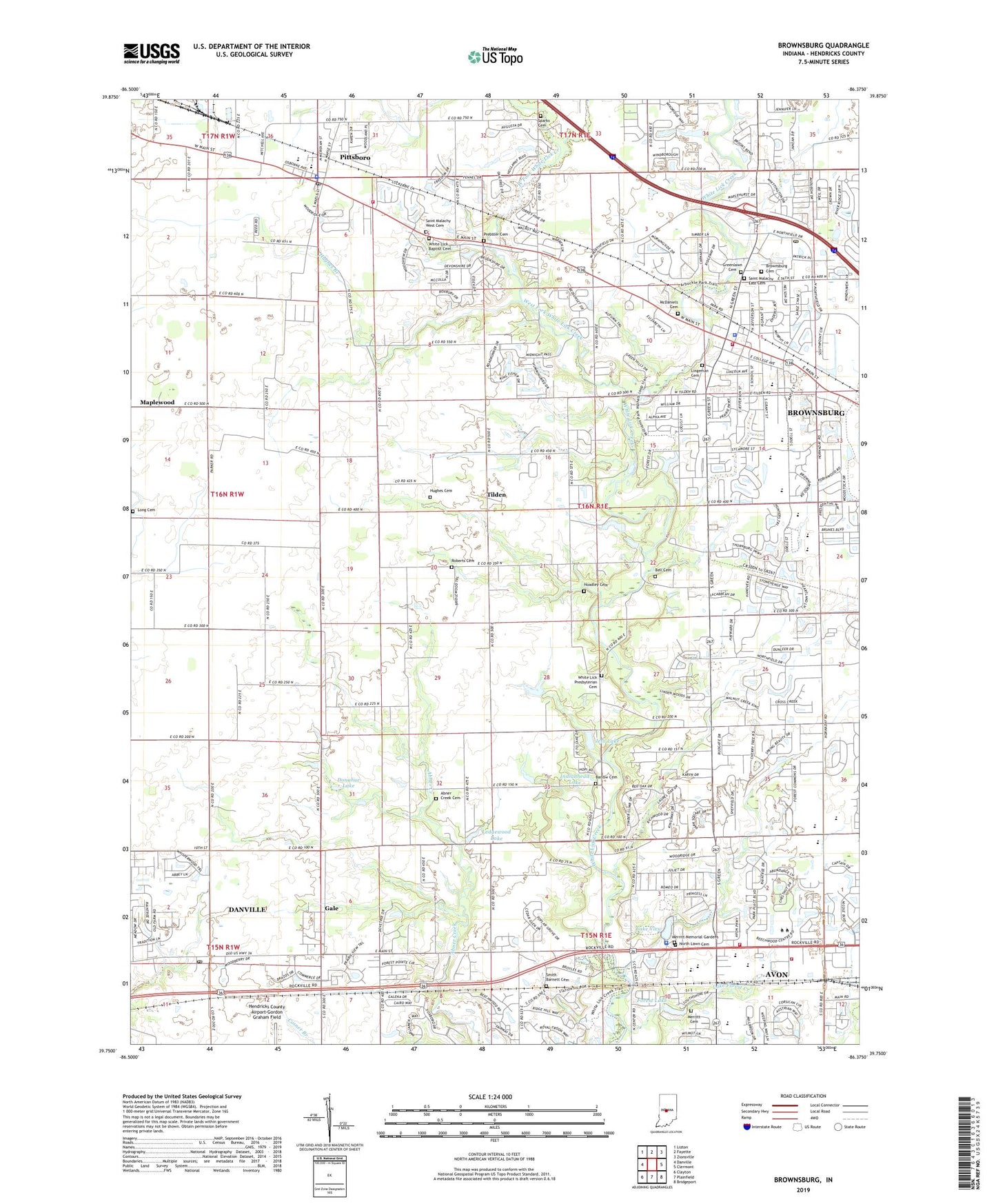
2022 topographic map quadrangle Brownsburg in the state of Indiana. Scale: 1:24000. Based on the newly updated USGS 7.5' US Topo map series, this map is in the following counties: Hendricks. The map contains contour data, water features, and other items you are used to seeing on USGS maps, but also has updated roads and other features. This is the next generation of topographic maps. Printed on high-quality waterproof paper with UV fade-resistant inks.
Quads adjacent to this one:
West: Danville
Northwest: Lizton
North: Fayette
Northeast: Zionsville
East: Clermont
Southeast: Bridgeport
South: Plainfield
Southwest: Clayton
This map covers the same area as the classic USGS quad with code o39086g4.
Contains the following named places: Abner Creek Cemetery, Apostolic Bible Church, Arbuckle Acres Park, Avon, Avon High School, Avon Lower Elementary School, Avon Middle School, Avon Police Department, Avon United Methodist Church, Avon Upper Elementary School, Barlow Cemetery, Bartlett Chapel United Methodist Church, Bell Cemetery, Brownsburg, Brownsburg Airport, Brownsburg Cemetery, Brownsburg Church of the Nazarene, Brownsburg Fire Station 131, Brownsburg Fire Territory Headquarters and Training Facility, Brownsburg High School, Brownsburg Intermediate School, Brownsburg Junior High School, Brownsburg Police Department, Brownsburg Post Office, Brownsburg Shopping Center, Brownsburg South Elementary School, Brownsburg Square Shopping Center, Calvary United Methodist Church, Danville Post Office, Donahue Lake, Donahue Lake Dam, Faith Baptist Church of Avon, Forest Lake, Forest Lake Dam, Gale, Greenlawn Cemetery, Hendricks County Golf Course, Hoadley Cemetery, Hughes Branch, Hughes Cemetery, Indianhead Lake, Jeto Creek, Jeto Lake, Kingsway Christian School, Lake Forest Creek, Lake View, Lake View Dam, Ledgewood Lake, Lewis Lake Dam, Lingeman Cemetery, Long Cemetery, McDaniels Cemetery, Memorial Church, Merritt Cemetery, Merritt Memorial Gardens, Messiah Lutheran Church, Methodist Medical Plaza, North Lawn Cemetery, Pittsboro, Pittsboro Baptist Church, Pittsboro Christian Church, Pittsboro Fire Department, Pittsboro Golf Club, Pittsboro Police Department, Pittsboro Post Office, Pittsboro School, Prebster Cemetery, Prestwick Country Club, Roark Stadium, Roberts Cemetery, Saint Malachy Church, Saint Malachy East Cemetery, Saint Malachy School, Saint Malachy West Cemetery, Smith Barnett Cemetery, Sparks Cemetery, Tilden, Town of Avon, Town of Brownsburg, Town of Pittsboro, Township of Lincoln, Township of Middle, Township of Washington, Ward Cemetery, Washington Township Avon Fire Department Headquarters, Washington Township Fire Department Station 141, West Fork White Lick Creek, White Lick Baptist Cemetery, White Lick Presbyterian Cemetery, White Lick Presbyterian Church, Williams Park, ZIP Codes: 46112, 46123