MyTopo
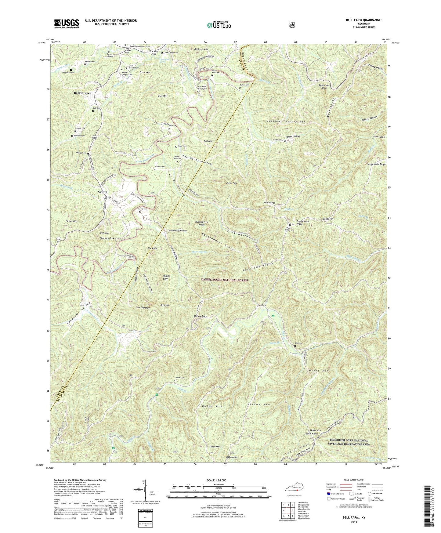
Bell Farm Kentucky US Topo Map
Couldn't load pickup availability
Also explore the Bell Farm Forest Service Topo of this same quad for updated USFS data
2022 topographic map quadrangle Bell Farm in the state of Kentucky. Scale: 1:24000. Based on the newly updated USGS 7.5' US Topo map series, this map is in the following counties: McCreary, Wayne. The map contains contour data, water features, and other items you are used to seeing on USGS maps, but also has updated roads and other features. This is the next generation of topographic maps. Printed on high-quality waterproof paper with UV fade-resistant inks.
Quads adjacent to this one:
West: Parmleysville
Northwest: Monticello
North: Coopersville
Northeast: Nevelsville
East: Barthell
Southeast: Oneida North
South: Barthell SW
Southwest: Sharp Place
This map covers the same area as the classic USGS quad with code o36084f6.
Contains the following named places: Anderson Cemetery, Backbone Ridge, Barrier Cemetery, Barrier Cemetery Number 2, Bawley Ford, Bell Cemetery, Bell Farm, Bell Farm Horse Camp, Bell Farm Post Office, Bell Hill, Bell Hill School, Bertram Mountain, Big Cliff, Burke-Kidd Cemetery, Burkes Branch, Burkes Cemetery, Burkes Creek, Carl Kidd Graveyard, Chimney Rock, Co-operative Division, Co-operative Post Office, Criswell Cemetery, David L Crownshed Grave, Deer Loop, Denney Ford, Denney Pumping Station, Denny Farm Cemetery, Dobbs Hill, Dobbs Hollow, Dobbs School, Dolen Branch, Dolen Mountain, Dolen School, Foster Cemetery, Foster Hollow, Foster Mountain, Frank Mountain, Fred Hollow, Full Hollow, Grant Roberts Cemetery, Great Meadow Campground, Green Ford, Green Ford Church, Gregory Branch, Gregory Cemetery, Gregory Post Office, Griffin, Griffin Cemetery, Griffin Oil Pool, Griffin Post Office, Griffin School Number 2, Hemlock Grove Camping Area, Hemlock Grove Picnic Area, Hill Cemetery, Hollow Rock, Huckleberry Hollow, Huckleberry Ridge, Jacksons Step-up Mountain, John Barrier Cemetery, Johnson Fork, Kennedy Creek, Lexton Mountain, Lonesome Creek, Lonesome Ford, Lonesome Valley, Middle Cliff, Peter Gap, Phelps Hollow, Phillips Cemetery, Pleasant Ridge Church, Puncheoncamp Branch, Racoon Loop, Rattlesnake Ridge, Rice Mountain, Rigney-Gregory Cemetery, Rocky Branch, Rocky Branch School, Rockybranch, Rockybranch Post Office, Ryan Cemetery, Shearer- Dobbs Cemetery, Siles Mountain, Skullbone Lookout Tower, Skullbones Knob, Slavans School, Smith Cemetery, Steele Cemetery, Steele Ford, Steele Hollow, Steele Old Mill, Stillhouse Hollow, Stone Dye Branch, The Caylor Cemetery, The Chimney, The Cutoff, The Denny Hollow, The Frank Spring, The Mill Cliff, The Pilot, Turkey Branch, Watts Branch, Watts Mountain, Wolf Ridge, Wolf Ridge Lookover, Wolf School, ZIP Code: 42647