MyTopo
Monticello Kentucky US Topo Map
Couldn't load pickup availability
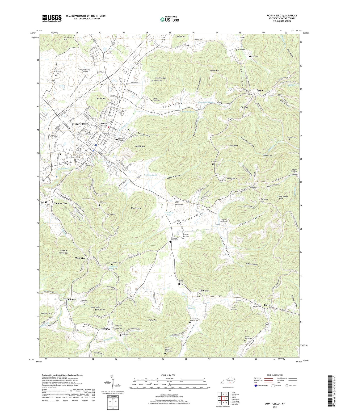
2022 topographic map quadrangle Monticello in the state of Kentucky. Scale: 1:24000. Based on the newly updated USGS 7.5' US Topo map series, this map is in the following counties: Wayne. The map contains contour data, water features, and other items you are used to seeing on USGS maps, but also has updated roads and other features. This is the next generation of topographic maps. Printed on high-quality waterproof paper with UV fade-resistant inks.
Quads adjacent to this one:
West: Parnell
Northwest: Jabez
North: Mill Springs
Northeast: Frazer
East: Coopersville
Southeast: Bell Farm
South: Parmleysville
Southwest: Powersburg
This map covers the same area as the classic USGS quad with code o36084g7.
Contains the following named places: Aaron Barrier Cemetery, Aggie Hollow, Alexander Cemetery, Andrew Jackson Roberts Cemetery, Bachelor Hollow, Barrier, Barrier Post Office, Bartleson Cemetery, Bartleson Hill, Beech Valley, Beech Valley Baptist Church, Beech Valley Cemetery, Beech Valley Inn, Benjamin Coffey Cemetery, Bollen Bell Cemetery, Burfield Hollow, Burgess Cemetery, Burgess Hollow, Burnett Hollow, Buster Hill, City of Monticello, Clark Lewis Cemetery, Coffey Mountain, Collum and Selena Coffey Cemetery, Cooper, Cooper School, County School Number 1, County School Number 2, County School Number 3, Crabtree Cemetery, Crabtree-Burgess Cemetery, Cross Pond, Cullom Rock, Dabney-Barrier Cemetery, Dobbs Mountain, Dodson-Ross Cemetery, Doublehead Spring, Draughn Hollow, Duncan Branch, Duncan Valley, Elk Ridge, Elk Ridge Church, Elk Spring, Elk Spring Cemetery, Elk Spring Valley, Elk Spring Valley Cemetery, Elk Spring Valley Church, Foster Cemetery, Foster Hollow, Four Neck Pond, Frank Cemetery, Frisbie Cemetery, Gibson Hollow, Grannie Hollow, Green Betty Cemetery, Hardin and Martha Coffey Cemetery, Hayden Cemetery, Hickory Nut Hill, Ike Burke Spring, Ingram Family Plot, Ingram-Vickery-Goodard Cemetery, Isaac Draughn Cemetery, Jesus Name Church, Keeton Hollow, Kendrick Cemetery, Kendrick Mountain, Kendrick Spring, Lonely Cemetery, Mack Lair Cemetery, Maggie Marshall Mill, Miller Cemetery, Missouri Hollow, Missouri Hollow Church, Monnie Flynn Spring, Monticello, Monticello Division, Monticello Fire Department, Monticello Police Department, Monticello Post Office, Morris Hill, Number One, Number One School, O P Lins Sawmill, Oil Valley, Oil Valley Post Office, Ranking Mill, Saint Peters Church, Sandusky Cemetery, Sandusky Chapel, Shoemaker Post Office, Sloan Coal Mine, Sloan Hollow, Spann, Spann Hill School, Spann Lookout Tower, Spann Post Office, Sulphur Spring Mountain, Sumpter, Sumpter Branch, Sumpter Post Office, Sumpter School, Sumpter-Lee Cemetery, Tank Knob, Taylor Cemetery, The One-Eye Hollow, The Pinnacle, The Rabbit Patch, The Round Rock, The Sand Cliff, Tradeway Shopping Center, Triangle S Farms Resort, Wayne County, Wayne County Airport, Wayne County Hospital, Wayne County Hospital Heliport, Wayne County Rescue Squad, Wayne County Sheriff's Office, Wayne County Speedway, Wayne Freedom Baptist Association, WFLW-AM (Monticello), Wilhite Mountain, Wither Cemetery, WKYM-FM (Monticello), WMKZ-FM (Monticello), Wray Gap, Wright Cemetery, Wright Hollow, ZIP Code: 42633