MyTopo
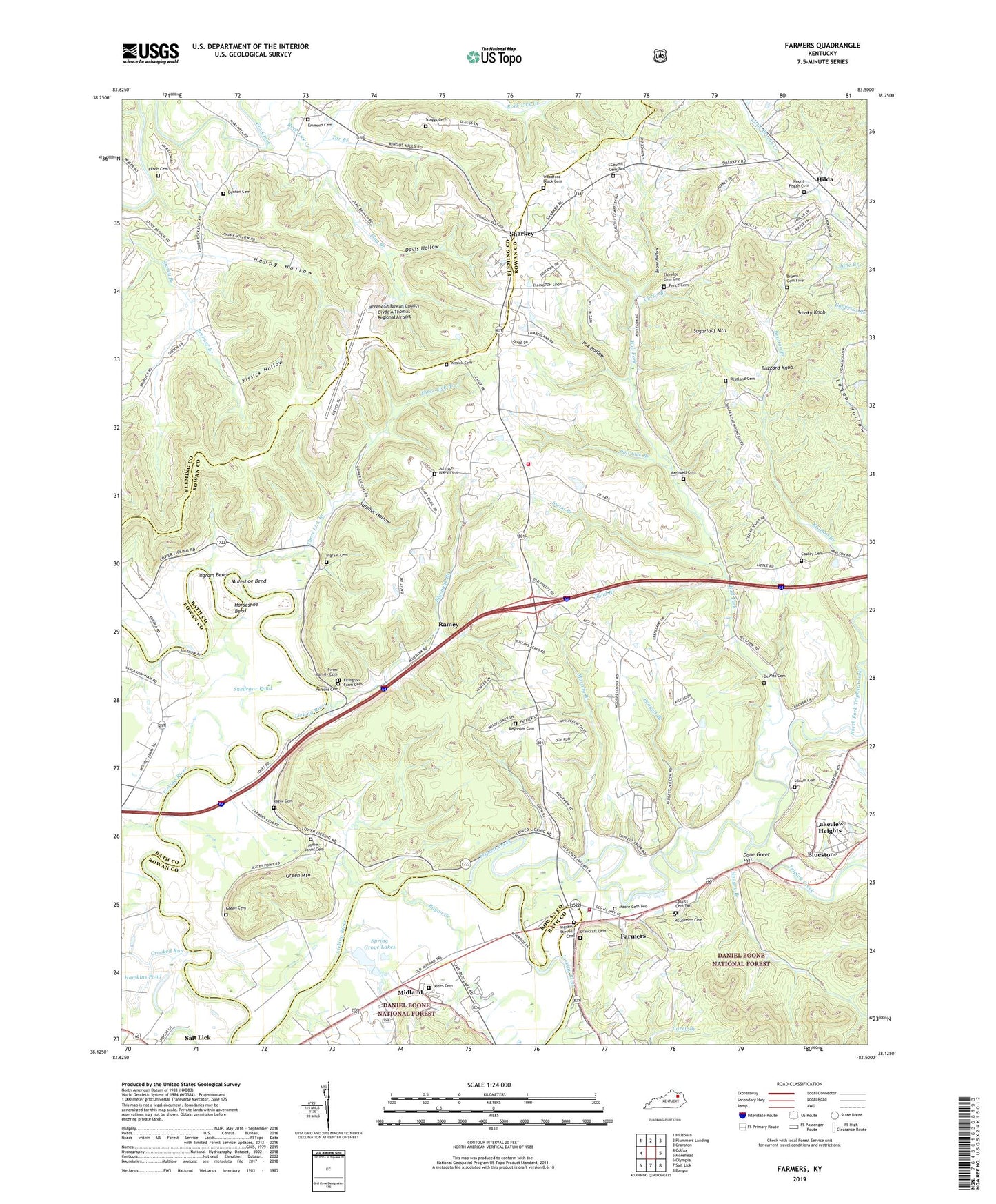
Farmers Kentucky US Topo Map
Couldn't load pickup availability
Also explore the Farmers Forest Service Topo of this same quad for updated USFS data
2022 topographic map quadrangle Farmers in the state of Kentucky. Scale: 1:24000. Based on the newly updated USGS 7.5' US Topo map series, this map is in the following counties: Rowan, Fleming, Bath. The map contains contour data, water features, and other items you are used to seeing on USGS maps, but also has updated roads and other features. This is the next generation of topographic maps. Printed on high-quality waterproof paper with UV fade-resistant inks.
Quads adjacent to this one:
West: Colfax
Northwest: Hillsboro
North: Plummers Landing
Northeast: Cranston
East: Morehead
Southeast: Bangor
South: Salt Lick
Southwest: Olympia
This map covers the same area as the classic USGS quad with code o38083b5.
Contains the following named places: Bayou Creek, Blue Bank School, Bluebank Branch, Bluebank Church, Bluestone, Boone Hollow, Brown Cemetery Five, Buckner Branch, Bull Fork, Buzzard Knob, Caskey Cemetery, Cassity Cemetery Two, Caudill Cemetery Two, City of Lakeview Heights, Cow Creek, Craycraft Cemetery, Crooked Run, Curtis Branch, Dane Greer Hill, Davis Hollow, De Witt Cemetery, Denton Cemetery, Eagle Trace Golf Course, Eldridge Cemetery One, Ellington Farm Cemetery, Emmons Cemetery, Farmers, Farmers Census Designated Place, Farmers Christian Church, Farmers Church, Farmers Elementary School, Farmers Volunteer Fire Department Station 1, Farmers Volunteer Fire Department Station 2, Filson Cemetery, Flag Branch, Fox Hollow, Freestone Railroad Station, Green Cemetery, Green Mountain, Happy Hollow, Hawkins Pond, Hilda, Hilda Post Office, Hilda School, Horseshoe Bend, Hungry Branch, Ingram - Stevens Cemetery, Ingram Bend, Ingram Cemetery, Isles Mills Post Office, James - Jones Cemetery, John Will Stacey Business Park, Johnson Black Cemetery, Jones Cemetery, Kissick Cemetery, Kissick Hollow, Lakeview Heights, Licking Post Office, Licking Railroad Station, Markwell Cemetery, McGlosson Cemetery, Midland, Midland Church of God, Midland Railroad Station, Moore Cemetery Two, Moore School, Moores Ferry, Moores Ferry Post Office, Morehead-Rowan County Clyde A Thomas Regional Airport, Morgans Fourth Raid Historical Marker, Mount Pisgah Cemetery, Mount Pisgah Church, Muleshoe Bend, Murphy Branch, North Fork Triplett Creek, Padgett Branch, Parsons Cemetery, Pence Cemetery, Pint Lick Branch, Poplar Spring Church, Ramey, Ramey Post Office, Razor Cemetery, Restland Cemetery, Reynolds Cemetery, Rock Lick Creek, Rock Lick School, Rockville Railroad Station, Sand Branch, Scaggs Cemetery, Sharkey, Sharkey Church, Sharkey Post Office, Sharkey School, Siloam Cemetery, Siloam Church, Slatey, Slatey Church, Slatey School, Smoky Knob, Snedegar Pond, Spring Grove Lakes, Sugarloaf Mountain, Sulphur Hollow, Swim Branch, Swim Family Cemetery, Tar Branch, Three Lick Branch, Triplett Creek, Woodford Black Cemetery