MyTopo
Wheelwright Kentucky US Topo Map
Couldn't load pickup availability
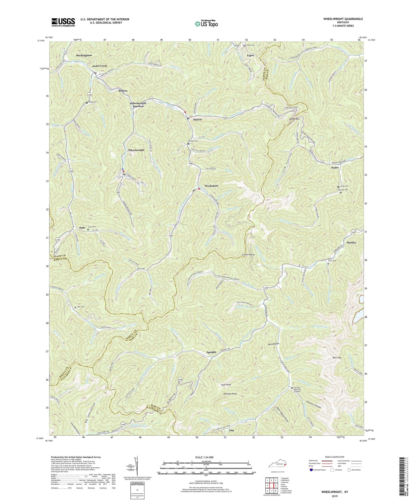
2022 topographic map quadrangle Wheelwright in the state of Kentucky. Scale: 1:24000. Based on the newly updated USGS 7.5' US Topo map series, this map is in the following counties: Pike, Floyd, Knott, Letcher. The map contains contour data, water features, and other items you are used to seeing on USGS maps, but also has updated roads and other features. This is the next generation of topographic maps. Printed on high-quality waterproof paper with UV fade-resistant inks.
Quads adjacent to this one:
West: Kite
Northwest: Wayland
North: McDowell
Northeast: Pikeville
East: Dorton
Southeast: Jenkins East
South: Jenkins West
Southwest: Mayking
This map covers the same area as the classic USGS quad with code o37082c6.
Contains the following named places: Abe Fork, Abel Tackett Fork, Abner Fork, Abner Mountain, Abner School, Adams Branch, Amil Little Cemetery, Bailey Branch, Beaver Fork, Bevinsville Post Office, Big Branch, Big John Hollow, Biscuit Post Office, Blackburn Branch, Blue Branch, Board Tree Branch, Bobs Branch, Box Fork, Buck Lick School, Buck Tackett Branch, Buckingham, Bucklick Fork, Bull Gap, Burke Cemetery, Burton, Bypro Post Office, Calamus Hollow, Caleb Fork, City of Wheelwright, Collier Rocks, Cook Cemetery, Dunbar High School, Elisha Fork, Enterprize Church, Etty, Etty Post Office, Fleming Memorial Gardens, Frozen Fork, Hall Cemetery, Halo, Harley, Hartley, Hartley Post Office, Hartley School, Head of Robinson Creek School, Henpen Branch, High Camp, High Knob, Honeycamp Branch, Isom Branch, Jacks Creek, John Brown Fork, Johns Fork, Johnson Branch, Johnson School, Joppa Church, Kate Fork, Left Fork Long Fork, Left Fork Otter Creek, Lick Fork, Ligon, Little Cemetery, Long Fork Church, Long Fork Division, Long Fork Post Office, Lower Jacks Creek School, Lower Long Fork, Lower Wales School, Marshall Branch, Marshall Branch School, Melvin, Melvin Post Office, Mill Branch, Mill Hollow, Muddy Gut Branch, Mudlick Branch, Muley Branch, Nats Fork, Newsom Branch, Orchard Branch, Orchard Fork, Osborne Cemetery, Osborne Fork, Otter Creek, Pettys Fork, Pigeonroost Fork, Pilgrim Church, Pine Fork, Poor Fork, Poplar Beetree Hollow, Potatoe Knob, Right Fork Long Fork, Right Fork of Long Fork, Right Fork of Long Fork School, Right Fork Otter Creek, Riley Branch, Riley Branch School, Rockhouse Fork, Rocky Branch, School 24, School Number 143, Skull Fork, Slone Branch, Slone Cemetery, Southeast Floyd County Volunteer Fire Department, Sow Hollow, Speight, Speight Post Office, Stonecoal Fork, Stover Fork, Sugarcamp Branch, Sycamore Branch, Tackett Cemetery, Tackett Post Office, Terry Branch, Turkey Pen, Turkeypen Branch, Upper Arnold Fork School, Upper Jacks Creek School, Upper Wales School, Wales, Wales Post Office, Weeksbury, Weeksbury Fire Department, Weeksbury Post Office, Wheelwright, Wheelwright Fire Department, Wheelwright Junction, Wheelwright Police Department, Wheelwright Post Office, Wheelwright-Weeksbury Division, Will Newson Branch, Wolfpen Branch, Yonts Branch, ZIP Codes: 41572, 41606, 41612, 41650, 41667, 41669, 41812