MyTopo
Paducah West Kentucky US Topo Map
Couldn't load pickup availability
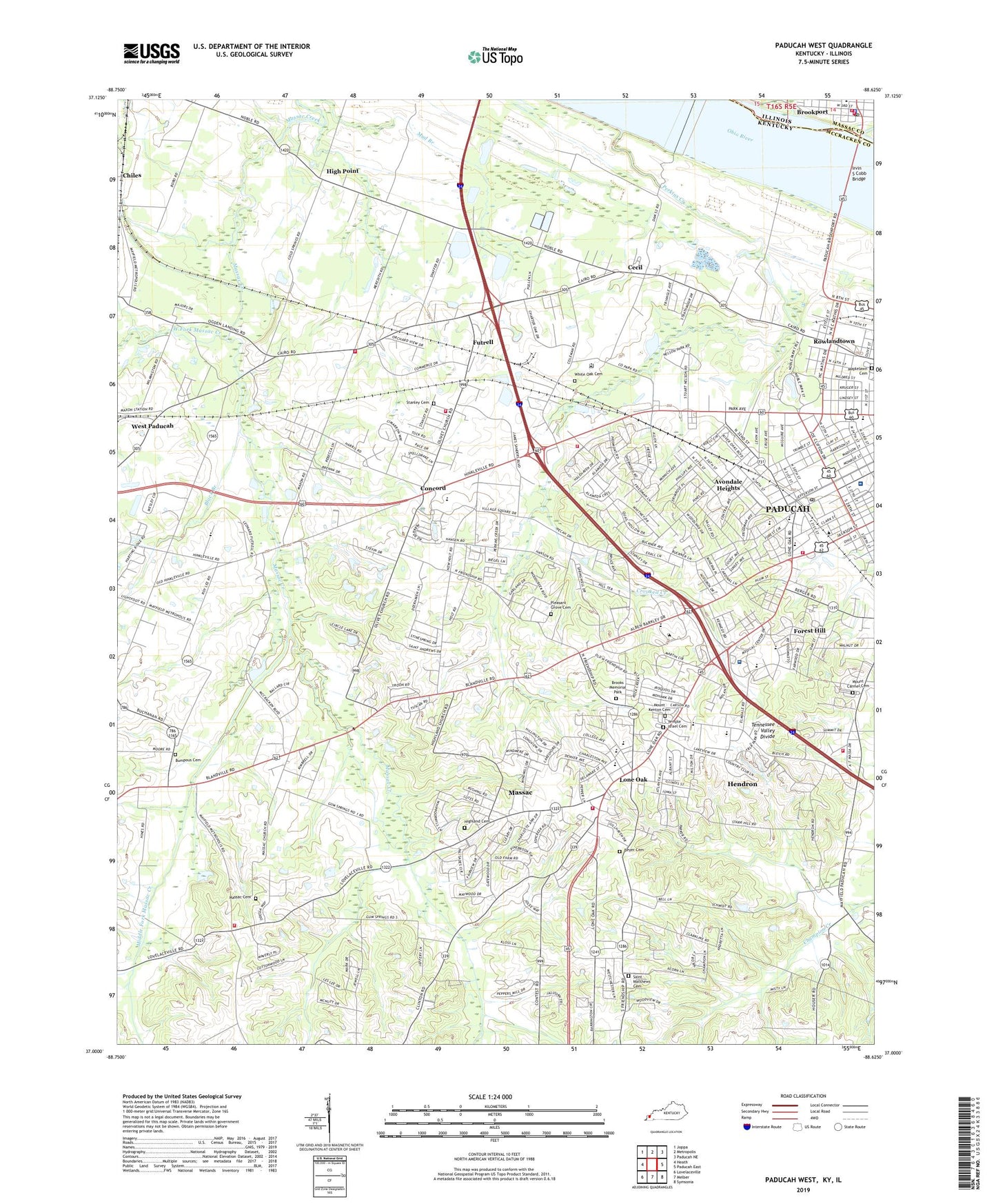
2022 topographic map quadrangle Paducah West in the states of Kentucky, Illinois. Scale: 1:24000. Based on the newly updated USGS 7.5' US Topo map series, this map is in the following counties: McCracken, Massac. The map contains contour data, water features, and other items you are used to seeing on USGS maps, but also has updated roads and other features. This is the next generation of topographic maps. Printed on high-quality waterproof paper with UV fade-resistant inks.
Quads adjacent to this one:
West: Heath
Northwest: Joppa
North: Metropolis
Northeast: Paducah NE
East: Paducah East
Southeast: Symsonia
South: Melber
Southwest: Lovelaceville
This map covers the same area as the classic USGS quad with code o37088a6.
Contains the following named places: Andrew Jackson School, Avondale Heights, Avondale Post Office, Baptist Health Paducah Hospital, Bellview Church, Beyer Cemetery, Black Branch, Brazelton School, Brookport, Brookport Elemenatary School, Brookport Fire Department, Brookport Police Department, Brookport Post Office, Brookport United Methodist Church, Brooks Memorial Park, Bumpous Cemetery, Carson Park, Cecil, Chiles, Church of Christ, Church of God, City of Lone Oak, City of Paducah, Clark School, Concord, Concord Fire Department Station 1, Concord Fire Department Station 3, Concord School, Crooked Creek, Dam Number 52, Forest Hill, Futrell, Hendron, Hendron Census Designated Place, Hendron Fire Department, High Point, Highland Cemetery, Highland Church, Hinkleville, Irvin S Cobb Bridge, Jacobs Lake, Keiler Park, Langs, Lebanon Church, Little Union Community Center, Lone Oak, Lone Oak Fire Department Station 1, Lone Oak Fire Department Station 2, Lone Oak Park, Long Hole, Lourdes Hospital, Lourdes Hospital Heliport, Maplelawn Cemetery, Massac, Massac Cemetery, Massac Census Designated Place, Massac County Fire Protection District Station 2, Maxon, Maxon Church, Maxon Station, McCracken County, McCracken Regional Juvenile Detention Center, McCracken Regional Juvenile Detention Center Alternative School, Mercy Regional Emergency Medical Services, Middle Fork Massac Creek, Mount Carmel Cemetery, Mount Kenton Cemetery, Noble Park, Ohio River Pool, Olivia Church, Paducah Division, Paducah Fire Department Station 3, Paducah Fire Department Station 4, Palestine, Palestine Church, Park Avenue Church, Paxton Park, Perkins Creek, Pleasant Grove, Pleasant Grove Cemetery, Pleasant Grove Church, Rolling Hills Country Club, Rowlandtown, Saint Matthews Cemetery, Spring Hill, Stanley Cemetery, Stewart Nelson Park, Superior Care Home, Temple Israel Cemetery, West Fork Massac Creek, West Kentucky School, West Paducah, West Paducah School, Western Baptist Hospital Heliport, White Oak Cemetery, White Oak Church, WKPD-TV (Paducah), ZIP Code: 42001