MyTopo
Palmer Kentucky US Topo Map
Couldn't load pickup availability
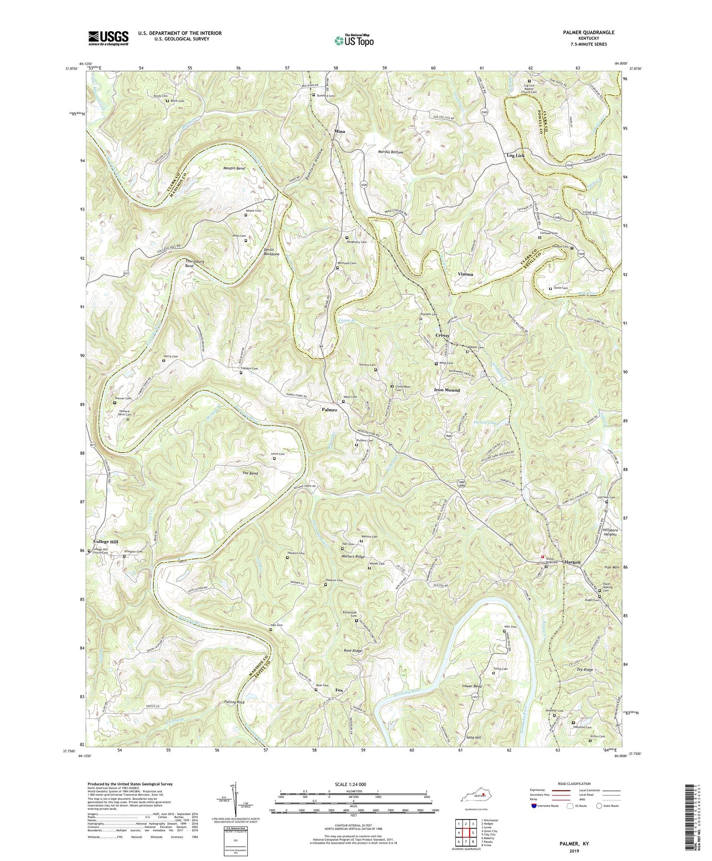
2022 topographic map quadrangle Palmer in the state of Kentucky. Scale: 1:24000. Based on the newly updated USGS 7.5' US Topo map series, this map is in the following counties: Estill, Clark, Madison, Powell. The map contains contour data, water features, and other items you are used to seeing on USGS maps, but also has updated roads and other features. This is the next generation of topographic maps. Printed on high-quality waterproof paper with UV fade-resistant inks.
Quads adjacent to this one:
West: Union City
Northwest: Winchester
North: Hedges
Northeast: Levee
East: Clay City
Southeast: Irvine
South: Panola
Southwest: Moberly
This map covers the same area as the classic USGS quad with code o37084g1.
Contains the following named places: Adams Cemetery, Alcorn Cemetery, Alexander School, Alexander School Neighborhood, Block Cemetery, Bogie, Bogie School, Brock Cemetery, Bull Run, Caney Branch, Christopher Cemetery, Clarksville, Cobb Ferry, College Hill, College Hill Church Cemetery, College Hill Post Office, College Hill Seminary, Corinth Church, Cottman Cemetery, Cotton Branch, Cotton Creek, Cotton's Store, Cow Creek, Cressy, Cressy Railroad Station, Daugherty Cemetery, Dawson Cemetery, Devils Backbone, Drownville Post Office, Dry Ridge, Dry Ridge Church, Dugan Cemetery, Dumford Cemetery, Dumford Hollow, Ellington Cemetery, Engle Post Office, Epperson, Epperson Church, Falling Branch, Falling Rock, Fielders Cemetery, Flint Creek, Fox, Fox Post Office, Friend Railroad Station, Goodes Hotel and Store, Goodes Precinct Post Office, Hall Cemetery, Hamilton Cemetery, Hargett, Hargett Church, Hargett Elementary School, Hargett Fire Station, Hargett Post Office, Hargett Railroad Station, Harris Cemetery, Hawkins Cemetery, Hillsboro Heights, Howard-Davis Cemetery, Howards Warehouse, Iron Mound, Iron Mound Post Office, Iron Mountain, Ivory Hill Church, Ivory Hill School, Jones Cemetery, Keas Tavern, Laramore Ferry, Legibson Post Office, Lewis Cemetery, Liberty Baptist Church, Lick Run, Lilly's Ferry, Lock Number 11, Log Lick, Log Lick Baptist Church, Log Lick Baptist Church Cemetery, Log Lick Creek, Log Lick Post Office, Long Branch, Lorrison Cemetery, Lower Bend, Lower Bend School, Lulbegrud Creek, Marsha Bottom, Maupin Bend, Merritt Post Office, Mina, Mina Railroad Station, Moreland Cemetery, Morgan Branch, Noland Creek, Owen Walling Cemetery, Palmer, Palmer Post Office, Parvin Post Office, Pine Ridge, Pine Ridge Church, Polecat Creek, Puckett Cemetery, Puckett Lake, Puckett Post Office, Raven Branch, Red River, Red River Ferry, Richardson Cemetery, Rose Cemetery, Rose Ridge, Sams, Sand Hill, Skinner Cemetery, Skyler King Cemetery, Snow Creek, South Fork Noland Creek, South Methodist Episcopal Church, Stevens Cemetery, Stone Cemetery, The Bend, The Bend School, The Forks, Thornsburg Bend, Tuttle Cemetery, Twin Creek, Twin Creek School, Vianna, Walters Cemetery, Walters Ridge, Webber Cemetery, Wells Cemetery, Wiseman Cemetery, Witt Cemetery, Woods Cemetery, Woodward Creek