MyTopo
Prestonsburg Kentucky US Topo Map
Couldn't load pickup availability
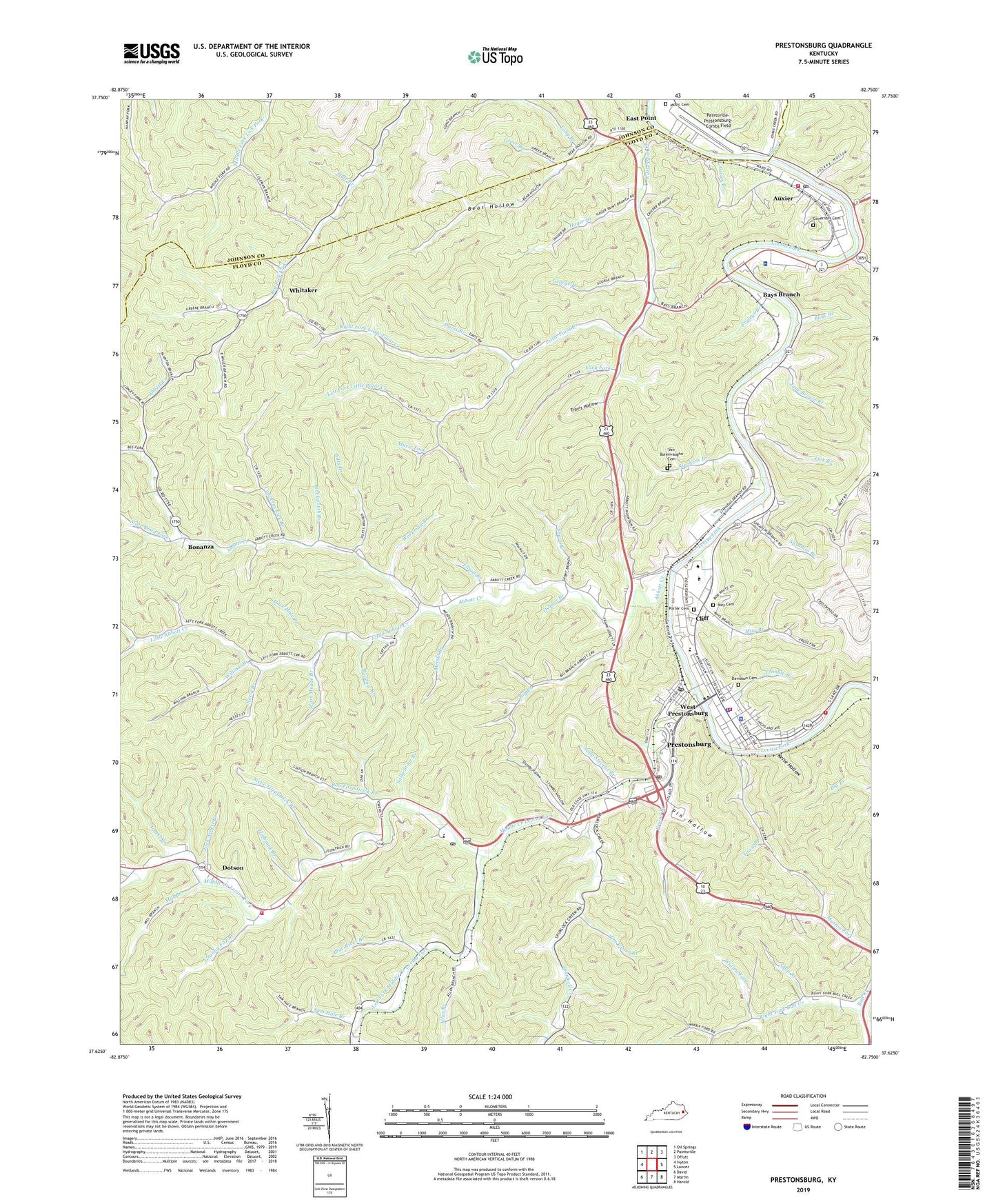
2022 topographic map quadrangle Prestonsburg in the state of Kentucky. Scale: 1:24000. Based on the newly updated USGS 7.5' US Topo map series, this map is in the following counties: Floyd, Johnson. The map contains contour data, water features, and other items you are used to seeing on USGS maps, but also has updated roads and other features. This is the next generation of topographic maps. Printed on high-quality waterproof paper with UV fade-resistant inks.
Quads adjacent to this one:
West: Ivyton
Northwest: Oil Springs
North: Paintsville
Northeast: Offutt
East: Lancer
Southeast: Harold
South: Martin
Southwest: David
This map covers the same area as the classic USGS quad with code o37082f7.
Contains the following named places: Abbott Creek, Abbott United Baptist Church, Allen Branch, Alley Fork, Archer Park, Arnett Branch, Auxier, Auxier Branch, Auxier Census Designated Place, Auxier Post Office, Auxier Volunteer Fire Department, Bays Branch, Bear Hollow, Bee Fork, Big Branch, Blue River Branch, Bob Fitzpatrick Branch, Bonanza, Buckhead Branch, Bull Creek Church, Burning Fork Community Church, City of Prestonsburg, Clark School, Cliff, Conley Fork, Copperas Lick Branch, Davidson Cemetery, Davis Branch, Dock, Dotson, Duck Hole Branch, East Kentucky Science Center, East Point, Elliott Branch, Faith Deliverance Tabernacle, First Christian Church, Fitzpatrick Post Office, Floyd County Sheriff's Office, Friend Branch, Friend Church, Fryleys Branch, George Branch, Governors Cemetery, Granny Fitz Branch, Greer Branch, Hackworth Branch, Hager Branch, Hale Branch, Highlands Appalachian Regional Healthare Regional Medical Center, Holbrook Branch, Horn Chapel, Hunter Branch, Ike Fitzpatrick Branch, Jack Arnett Branch, Jane Brown Branch, Jim Potter Branch, Jim Ward Branch, Jockey Hollow, Johns Creek, Kelse Hollow, Left Fork Little Paint Creek, Left Fork Middle Creek Levisa Fork, Lick Branch, Little Abbott Creek, Little Paint Creek, Long Branch, Mart Meade Branch, May Branch, May Cemetery, Meade Branch, Meadow Branch, Middle Creek Levisa Fork, Middle Creek Volunteer Fire Department, Mill Branch, Mountain Arts Center, Mullin Branch, Music Cemetery, Music Fork, Neely Branch, Osborn Branch, Paintsville-Prestonsburg-Combs Field, Pin Hollow, Porter Cemetery, Potts Branch, Prater Fork, Prestonburg Community College, Prestonburg Community College Campbell Hall, Prestonburg Community College Student Center, Prestonsburg, Prestonsburg City Fire Department, Prestonsburg Division, Prestonsburg Fire Department Station 2, Prestonsburg Police Department, Prestonsburg Post Office, Pruitt Memorial Church, Puckett Fork, Right Fork Bull Creek, Right Fork Little Paint Creek, Road Branch, Rough and Tough Branch, Saint James Episcopal Church, Sally Stevens Branch, Sally Stout Branch, Sam Hale Branch, Shop Branch, Short Branch, Shot Gun Hollow, Spradlin Branch, Spradlin Branch School, Spurlock Creek, State Road Fork, Stephens Branch, Steve Fitzpatrick Branch, Stumbo Hollow, The Bible Fellowship Church, The Father House Church, Tom Moore Memorial Baptist Church, Town Branch, Town Branch Church, Travis Hollow, Trimble Branch, Van Burenvaughn Cemetery, Wallen Fork, WDOC-AM (Prestonsburg), West Prestonsburg, West Prestonsburg Post Office, Whitaker, William Branch, Workman Branch, WPRT-AM (Prestonsburg), WQHY-FM (Prestonsburg), WXKZ-FM (Prestonsburg), ZIP Codes: 41216, 41602, 41607, 41653