MyTopo
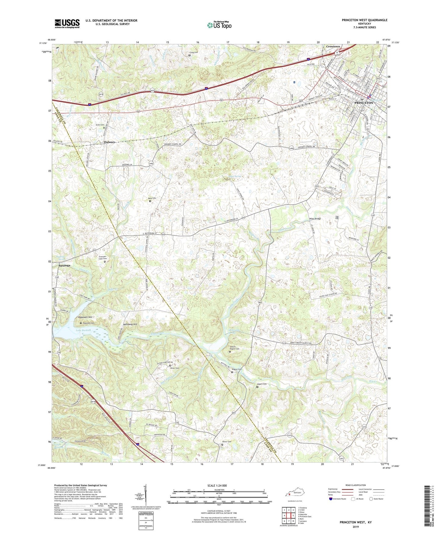
Princeton West Kentucky US Topo Map
Couldn't load pickup availability
Also explore the Princeton West Forest Service Topo of this same quad for updated USFS data
2022 topographic map quadrangle Princeton West in the state of Kentucky. Scale: 1:24000. Based on the newly updated USGS 7.5' US Topo map series, this map is in the following counties: Caldwell, Lyon. The map contains contour data, water features, and other items you are used to seeing on USGS maps, but also has updated roads and other features. This is the next generation of topographic maps. Printed on high-quality waterproof paper with UV fade-resistant inks.
Quads adjacent to this one:
West: Eddyville
Northwest: Fredonia
North: Crider
Northeast: Olney
East: Princeton East
Southeast: Cobb
South: Lamasco
Southwest: Mont
This map covers the same area as the classic USGS quad with code o37087a8.
Contains the following named places: Beck Cemetery, Big Spring, Big Spring Branch, Caldwell Chapel, Caldwell County Emergency Medical Services, Caldwell County Hospital, Caldwell County Sheriff's Office, Calvary Baptist Church, City of Princeton, Craig Cemetery, Dry Creek, Dry Fork Creek, Dulaney, Eastside School, Eddy Creek Baptist Church, Freeman - Cash Cemetery, Friendship Church, Glass Creek, Goose Creek, Gromes Chapel, Hallaway Hill, Harpending Springs, Hayes Spring, Hilltop Center School, Hollinsworth Post Office, Hopewell Cemetery, Hopewell Hill, Kilgore Cemetery, Oliver - Fuqua Cemetery, Oliver - Jones Cemetery, Pilfer Creek, Princeton, Princeton Country Club, Princeton Fire Department, Princeton Police Department, Princeton Post Office, Ratliff Park, Robertson Creek, Rock Spring, Rock Spring Church, Rogers Cemetery, Saint Pauls School, Sand Hollow Creek, Saratoga, Saratoga Spring, Scott Branch, Scott Cemetery, Sebron - Kilgore Cemetery, South Yard, Southside Church, Spillman Chapel, Sweetwater Creek, V F W Park, Wallace Branch, Westside School, Wiley Bridge