MyTopo
Slade Kentucky US Topo Map
Couldn't load pickup availability
Also explore the Slade Forest Service Topo of this same quad for updated USFS data
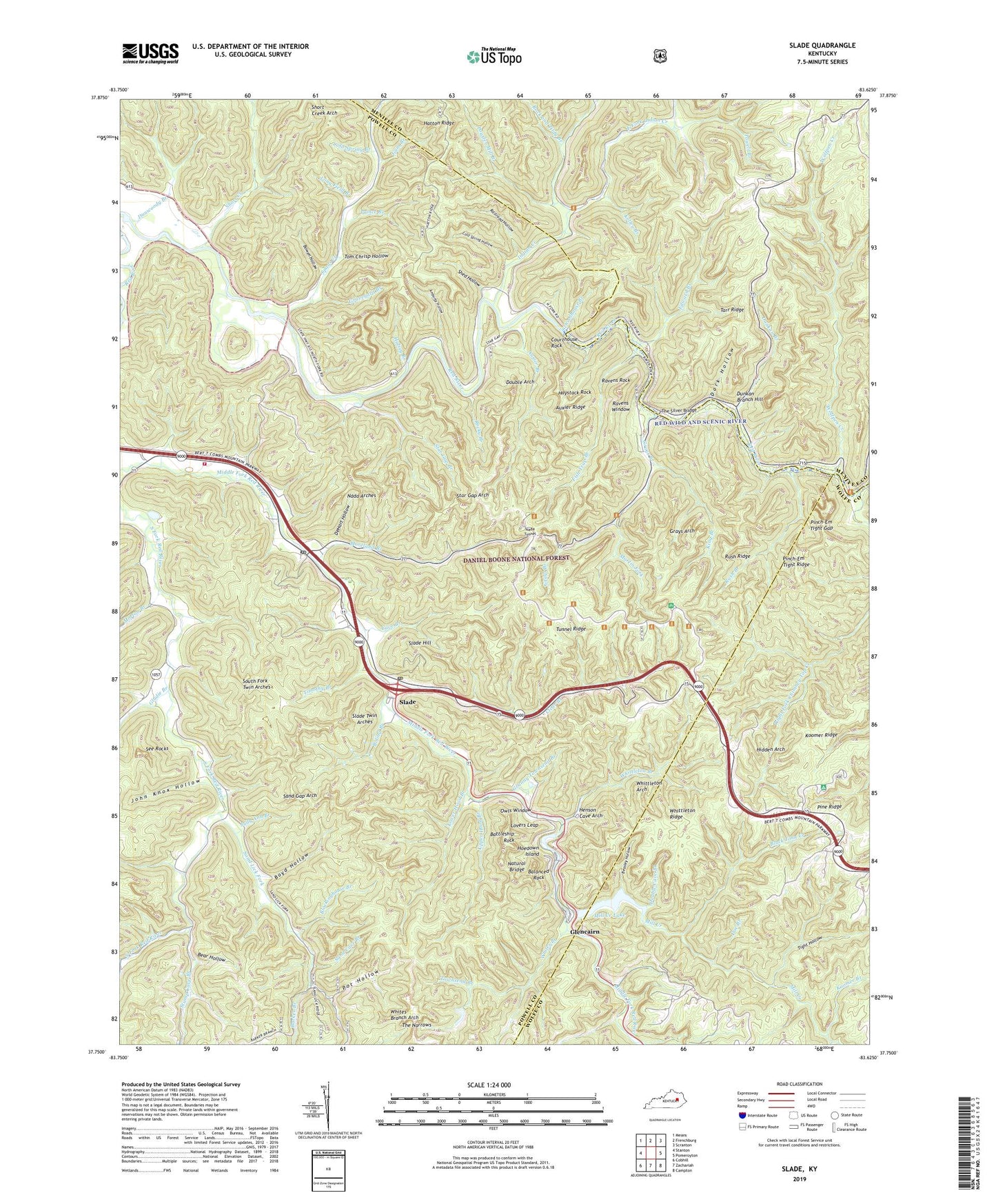
2022 topographic map quadrangle Slade in the state of Kentucky. Scale: 1:24000. Based on the newly updated USGS 7.5' US Topo map series, this map is in the following counties: Powell, Wolfe, Menifee. The map contains contour data, water features, and other items you are used to seeing on USGS maps, but also has updated roads and other features. This is the next generation of topographic maps. Printed on high-quality waterproof paper with UV fade-resistant inks.
Quads adjacent to this one:
West: Stanton
Northwest: Means
North: Frenchburg
Northeast: Scranton
East: Pomeroyton
Southeast: Campton
South: Zachariah
Southwest: Cobhill
This map covers the same area as the classic USGS quad with code o37083g6.
Contains the following named places: Amburgy Hollow, Amphitheater Trail, Auxier Branch, Auxier Branch Trail, Auxier Ridge, Auxier Ridge Trail, Balanced Rock, Barker Branch, Barker School, Battleship Rock, Bear Hollow, Beasley Hollow, Big Cordual Branch, Big Sinking Oil Field, Big Woods School, Black John Creek, Blackinghouse Branch, Boling Branch, Bowen Hollow, Boyd Hollow, Bragg Post Office, Buck Trail, Cave Branch, Chimney Top Creek, Chimney Top Railroad Station, Clear Branch, Clida Post Office, Cloud Splitter Rock, Cold Spring Branch, Cold Spring Hollow, Courthouse Rock, Courthouse Rock Trail, Crow, Dark Hollow, DeHart Hollow, Doe Branch, Double Arch, Double Arch Trail, Double Cave Branch, Dunkan Branch, Dunkan Branch Hill, Dunwoody Branch, Dunwoody Church, East Fork Indian Creek, Edward Branch, Fish Trap Branch, Fortner, Frenchburg Correctional Facility, Gladie Branch, Glencairn, Glencairn Church, Glencairn Post Office, Glencairn Railroad Station, Glencairn School, Granny Townsend Branch, Graveyard Branch, Grays Arch, Grays Arch Picnic Area, Grays Arch Trail, Grays Branch, Graysarch Trail, Gum Branch, Halsey Branch, Haystack Post Office, Haystack Rock, Henson Cave Arch, Hidden Arch, Hoedown Island, Indian Creek, John Knox Hollow, Judy Ann Branch, Junior Williamson Rest Area, Kelley Branch, King Branch, Koomer Branch, Koomer Ridge, Koomer Ridge Camping and Picnic Area, Koomer Ridge Trail, Landsome Branch, Long Field Branch, Lookout Point, Lovers Leap, Lower Hood Branch, Martin Fork, Middle Fork Campground, Middle Fork Church, Middlefork Fire Department, Mill Creek, Mill Creek Lake, Moreland Branch, Moreland Branch Church, Morton Branch, Mountain Top Railroad Station, Nada Arches, Nada Lombard Post Office, Nada Railroad Station, Nada Tunnel, Natural Bridge, Natural Bridge Post Office, Natural Bridge State Park, Natural Bridge Station, Needle Eye, Old Lombard, Owls Window, Pinch-Em Tight Gap, Pinch-Em Tight Ridge, Pinch-Em Tight Trail, Pine Ridge, Pine Ridge Lookout Tower, Pot Hollow, Powder Mill Branch, Powell Branch, Prince Branch, Railroad Hollow, Ravens Rock, Ravens Window, Rock and Tildy Branch, Rocky Branch, Rough Trail, Rush Branch, Rush Ridge, Rush Ridge Trail, Sand Cave Branch, Sand Gap Arch, Sand Lick Fork, Schoolhouse Branch, See Post Office, See Rocks, Shed Hollow, Short Creek, Short Creek Arch, Silvermine Arch Trail, Slade, Slade Hill, Slade Post Office, Slade Railroad Station, Slade Twin Arches, South Fork, South Fork Church, South Fork Twin Arches, Spaas Creek, Spaas Creek Post Office, Star Gap Arch, Star Gap Branch, Stump Cave Branch, Tarr Ridge, Tarr Ridge Picnic Area, The Devils Pulpit, The Narrows, The Silver Bridge, Tight Hollow, Timothy Branch, Tin Town Church, Tom Chrisp Hollow, Townsend Branch, Tunnel Ridge, Upper Hood Branch, Whites Branch, Whites Branch Arch, Whittleton Arch, Whittleton Branch, Whittleton Branch Trail, Whittleton Campground, Whittleton Ridge, Wolfpen Creek, ZIP Code: 40376