MyTopo
Rock Hall Maryland US Topo Map
Couldn't load pickup availability
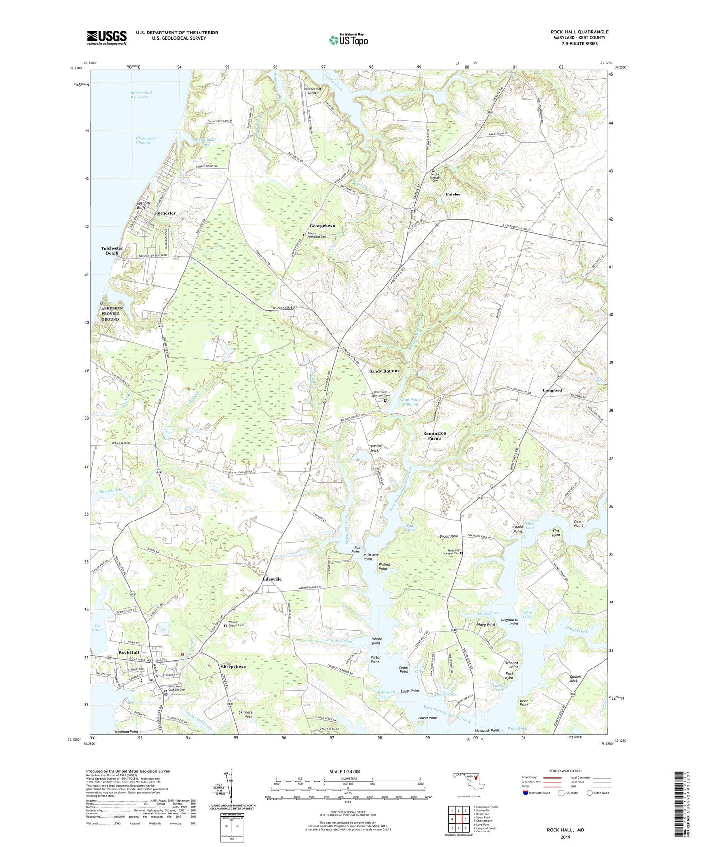
2019 topographic map quadrangle Rock Hall in the state of Maryland. Scale: 1:24000. Based on the newly updated USGS 7.5' US Topo map series, this map is in the following counties: Kent. The map contains contour data, water features, and other items you are used to seeing on USGS maps, but also has updated roads and other features. This is the next generation of topographic maps. Printed on high-quality waterproof paper with UV fade-resistant inks.
Quads adjacent to this one:
West: Swan Point
Northwest: Gunpowder Neck
North: Hanesville
Northeast: Betterton
East: Chestertown
Southeast: Centreville
South: Langford Creek
Southwest: Love Point
Contains the following named places: Asbury Methodist Cemetery, Asbury United Methodist Church, Bacchus Mill, Baywood Manor, Becks Landing, Blackstone Mill, Bramble Lake, Breezecroft Airport, Broad Neck, Browns Landing, Bungay Creek, Camp Fairlee Manor, Carpenter Farm Pond Dam, Caulks Field, Caulks Field Memorial, Cedar Point, Circle Park Trailer Park, Coleman Wharf, Deadman Point, Deep Point, Delta Heights, Denbigh, District 6 Fairlee, Eagle Point, Edesville, Edesville Census Designated Place, Edesville Park, Fairlee, Fairlee Census Designated Place, Fairlee Lake, Fairlee Lake Dam, Fairlee Post Office, Flat Point, Fox Point, Georgetown, Georgetown Census Designated Place, Goose Hollow, Graveyard Cove, Grove Wharf, Hadaway Chapel, Hadaway Chapel Cemetery, Harborview Farms, Haven Harbour Marina, Hawbush Point, Hidden Acres, Hills Cove, Horner Cove, Island Point, Kent Acres, Kent Agricultural Center, Kent County Agricultural Center, Kings Creek, Langford, Langford Bay Estates, Langford Farm, Learys Wharf, Long Cove, Longmarsh Point, Lovely Cove, Lovely Creek, McCleans Corner, Mendinhall Lake, Millstone Point, Mitchell Bluff, Mount Pleasant Cemetery, Mount Pleasant Church, Nike Site BA-30/31C, Nike Site BA-30/31L, Orchard Point, Pastor Point, Philip Creek, Piney Point, Poplar Neck, Rees Cross Road, Rees Wharf, Reeses Corner, Remington Farms, Remington Farms National Wildlife Preserve, Rock Hall, Rock Hall Civic Center, Rock Hall Elementary School, Rock Hall Harbor, Rock Hall Library, Rock Hall Middle School, Rock Hall Museum, Rock Hall Police Department, Rock Hall Post Office, Rock Hall Seventh Day Adventist Church, Rock Hall Town Hall, Rock Hall United Methodist Church, Rock Hall Volunteer Fire Company Station 7, Rock Hall Wastewater Treatment Plant, Rock Point, Saint Johns Catholic Cemetery, Saint Johns Catholic Church, Saint Pauls Church, Saint Pauls Episcopal Cemetery, Saint Pauls Millpond, Saint Pauls Millpond Dam, Salem Methodist Episcopal Church, Sandy Bottom, School Number 10, School Number 2, School Number 4, School Number 6, School Number 9, Sharps Wharf, Sharpstown, Shipyard Creek, Shipyard Landing, Sinai Cove, Smiths Cross Roads, Spring Cove Boat Ramp, The Haven, Tolchester, Tolchester Beach, Tolchester Beach Post Office, Tolchester Census Designated Place, Tolchester Estates, Tolchester Heights, Tolchester Marina, Town of Rock Hall, Vickers Wharf, Walnut Point, Wann Cove, Weir Cove, Wesley Chapel, Wesley Chapel Cemetery, Whale Point, Woods Edge