MyTopo
Brockton Massachusetts US Topo Map
Couldn't load pickup availability
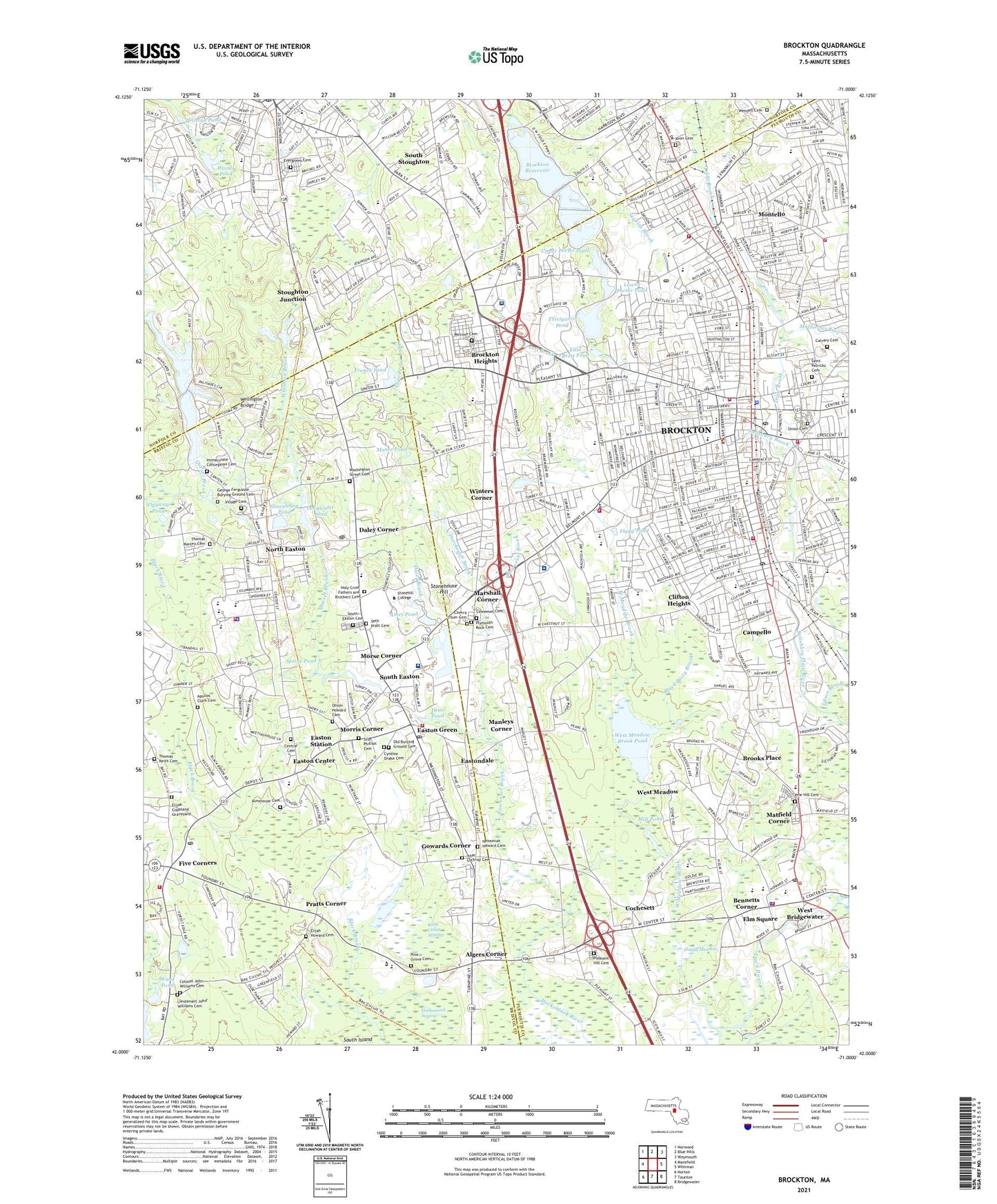
2021 topographic map quadrangle Brockton in the state of Massachusetts. Scale: 1:24000. Based on the newly updated USGS 7.5' US Topo map series, this map is in the following counties: Plymouth, Bristol, Norfolk. The map contains contour data, water features, and other items you are used to seeing on USGS maps, but also has updated roads and other features. This is the next generation of topographic maps. Printed on high-quality waterproof paper with UV fade-resistant inks.
Quads adjacent to this one:
West: Mansfield
Northwest: Norwood
North: Blue Hills
Northeast: Weymouth
East: Whitman
Southeast: Bridgewater
South: Taunton
Southwest: Norton
Contains the following named places: Algers Corner, Ames High School, Ames Long Pond, Ames Pond, Ames Pond Dam, Ashland School, Beaver Brook, Bennetts Corner, Bickley Playground, Bigney Pond, Bigney Pond Dam, Black Betty Brook, Brittons Pond, Brockton, Brockton Airport, Brockton Country Club, Brockton Golf Club, Brockton Heights, Brockton High School, Brockton Reservoir, Brockton Reservoir Dam, Brockton Station, Brockton US Army Reserve Center Heliport, Brookfield School, Brooks Place, Butler Elementary School, Calvary Cemetery, Campanelli Industrial Park, Campello, Campello Station, Cardinal Cushing Hospital, Cary Brook, Cary Hill Plaza, Cedar Hill Golf Course, Center School, Center Shopping Plaza, Central Cemetery, Chevra Tilum Cemetery, City of Brockton, Clifton Heights, Cochesett, Cochesett Station, Copeland School, Coweeset Brook, Coweeset Cemetery, Cross Pond, Cynthia Drake Cemetery, D W Field Golf Course, D W Field Park, Daley Brook, Daley Corner, Davis Square, Dean Pond, Doctor W Arnone Community School, Dorchester Brook, East Ashland Shopping Plaza, East Junior High School, Easton Center, Easton Country Club, Easton Green, Easton Junior High School, Easton Station, Eastondale, Edgar School, Edson Brook, Edwin A Jones School, Elijah Howard Cemetery, Ellis Brett Pond, Ellis Brett School, Elm Square, Evergreen Cemetery, Five Corners, Flagg Pond, Flaggy Meadow, Flyaway Pond, Forest Avenue School, Franklin School, French Brook, French Pond, French Pond Dam, Furnace Village School, George G Snow Park, Gilbert Walker Playground, Gilmore School, Goddard Hospital Heliport, Goddard Memorial Hospital, Goddard School, Good Samaritan Medical Center, Gowards Corner, Hancock Field, Hancock School, Holy Cross Seminary, Howard School, Howard Seminary, Howard Spring Street School, Huntington School, Immaculate Conception Cemetery, Ithaka-Lincoln School, Jas Edgar Playground, Jerusalem School, John F Kennedy School, Joseph F Plouffe Elementary School, Joseph H Gibbons School, Keith Memorial Field, Keith School, Keys to the Kingdom Christian School, Kimball School, Little Cedar Swamp, Longwater Pond, Longwater Pond Dam, Louis F Angelo Elementary School, Lovett Brook, Lower Porter Pond, Lower Porter Pond Dam, Malfardar Brook, Manleys Corner, Marciano Stadium, Marshall Corner, Matfield Corner, May Center for Education and Neurorehabilitation, Melrose Cemetery, Mill Pond, Mill Pond Dam, Monte Pond, Monte Pond Dam, Montello, Montello Station, Moreau Hall School, Morris Corner, Morse Corner, Morse Pond, Morse Pond Dam, Mulberry Brook, Nelson Playground, New England Baptist Academy, North Cary School, North Easton, North Easton Grammar School, North Junior High School, Oscar F Raymond School, Paine School, Parkview Elementary School, Perkins School, Pine Grove Cemetery, Pine Hill Cemetery, Pine Valley Country Club, Pine Valley Golf Club, Pleasant Hill Cemetery, Plymouth Rock Cemeteries, Points West Plaza, Pratts Corner, Puffer Playground, Pulaski Square, Queset Brook, Rose L MacDonald School, Russell School, Saint Edwards School, Saint Patricks Cemetery, Salisbury Brook, Searles Brook, Sequassett Station, Shaws Plaza Shopping Center, Shovelshop Pond, Shovelshop Pond Dam, Smith School, South Easton, South Easton Cemetery, South Easton Station, South Elementary School, South Island, South Junior High School, South Stoughton, South Street Historic District, Southeastern Technical Institute, Southgate Plaza, Stonehill College, Stonehouse Hill, Stoughton Junction, Stoughton Station, The Village Mall, Thirtyacre Pond, Thorny Lea Golf Club, Thorny Lea Golf Course, Tolman School, Town Farm, Town of Easton, Town of Stoughton, Town of West Bridgewater, Trout Brook, Turkis Playground, Union Cemetery, Unionville School, United States Veterans Administration Hospital, Upper Porter Pond, Upper Porter Pond Dam, Veracka Heliport, Veterans Affairs Boston Healthcare System Brockton Division, Village Stores Shopping Center, Waldo Lake, Waldo Lake Dam, Ward Pond, Washington Street Cemetery, WBET-AM (Brockton), WCAV-FM (Brockton), Wedgewood Country Club, Wellington Bridge, Wendell Cemetery, West Bridgewater, West Bridgewater High School, West Bridgewater Junior-Senior High School, West Bridgewater Station, West Junior High School, West Meadow, West Meadow Brook, West Meadow Brook Dam, West Meadow Brook Pond, West Meadow Wildlife Reservation, West Shopping Center, Westgate Mall, Westgate Shopping Center, Wheelers Pond, Whitman Brook, Whitman School, Winters Corner, Winthrop School, Winthrop Square, WMSX-AM (Brockton), Woods Pond, WSHL-FM (Easton), ZIP Codes: 02072, 02301, 02356, 02357, 02375, 02379