MyTopo
Head of Westport Massachusetts US Topo Map
Couldn't load pickup availability
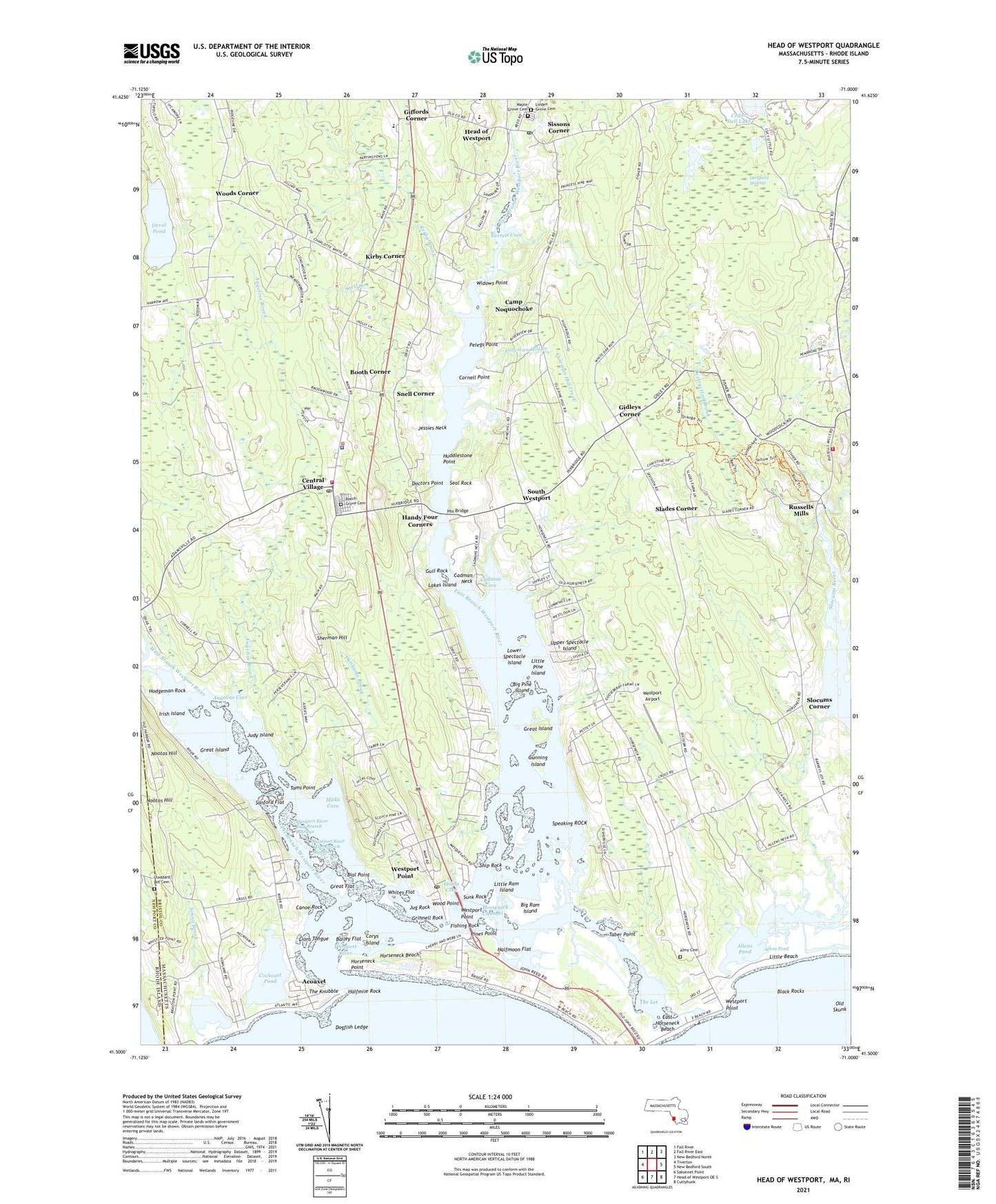
2024 topographic map quadrangle Head of Westport in the state of Massachusetts. Scale: 1:24000. Based on the newly updated USGS 7.5' US Topo map series, this map is in the following counties: Bristol, Newport. The map contains contour data, water features, and other items you are used to seeing on USGS maps, but also has updated roads and other features. This is the next generation of topographic maps. Printed on high-quality waterproof paper with UV fade-resistant inks.
Quads adjacent to this one:
West: Tiverton
Northwest: Fall River
North: Fall River East
Northeast: New Bedford North
East: New Bedford South
Southeast: Cuttyhunk
South: Head of Westport OE S
Southwest: Sakonnet Point
Contains the following named places: Acoaxet, Allen Creek, Allens Pond, Allen's Pond Airport, Almy Burial Ground, Angeline Brook, Angeline Cove, Bailey Flat, Beech Grove Cemetery, Bial Point, Big Pine Island, Big Ram Island, Black Rocks, Booth Corner, Cadman Cove, Cadman Neck, Camp Noquochoke, Canoe Rock, Cedar Dell Lake, Central Village, Central Village Commons, Central Village Post Office, Cockeast Pond, Coleman Hill Creek, Cornell Point, Corys Island, Dartmouth Fire Department District 2, Deerfield Swamp, Destruction Brook, Devol Pond, Doctors Point, Dogfish Ledge, Doll Museum, Dunhams Brook, Earle School, East Branch Westport River, East Horseneck Beach, Everett Cove, Fishing Rock, Flynns Noquochoke Seaplane Base, Free Chapel, Gidleys Corner, Giffords Corner, Great Flat, Great Island, Grinnell Rock, Gull Rock, Gunning Island, Halfmile Rock, Halfmoon Flat, Handy Four Corners, Head of Westport, Hicks Cove, Hix Bridge, Hodgeman Rock, Holy Ghost Church, Horseneck Beach, Horseneck Beach State Reservation, Horseneck Channel, Horseneck Point, Horseneck Seaplane Base, Huddlestone Point, Hulda Cove, Irish Island, Jessies Neck, Judy Island, Jug Rock, Kirby Brook, Kirby Corner, Lakes Island, Linden Grove Cemetery, Lions Tongue, Little Beach, Little Pine Island, Little Ram Island, Lower Spectacle Island, Macombers Corner, Maple Grove Cemetery, New Bedford City Rifle Range, Nootas Hill, Noquochoke Post Office, Old Skunk, Paskamanset River, Pelegs Point, Pines Point, Richmond Pond, Russells Mills, Saint Vincent de Paul Camp, Sanford Flat, Seal Rock, Sherman Hill, Ship Rock, Simon Brook, Sissons Corner, Slades Corner, Slocums Corner, Snell Corner, Snell Creek, South Westport, Speaking ROCK, Sunk Rock, Taber Point, The Knubble, The Let, The Narrows, Toms Point, Town of Westport, University Highlands, Upper Spectacle Island, West Branch Westport River, Westport Airport, Westport Elementary School, Westport Fire Department Station 1, Westport Free Library, Westport Harbor, Westport Harbor Entrance Light, Westport High School, Westport Light, Westport Middle School, Westport Middle School Media Center, Westport Point, Westport Point Post Office, Westport Police Department, Westport River, Westport River East Branch Marshes, Westport River West Branch Marshes, Westport Town Forest, Westport Town Hall, Westport Townhall, Westport Yacht Club, Whites Flat, Widows Point, Wood Point, Woods Corner, ZIP Codes: 02790, 02791