MyTopo
Pocasset Massachusetts US Topo Map
Couldn't load pickup availability
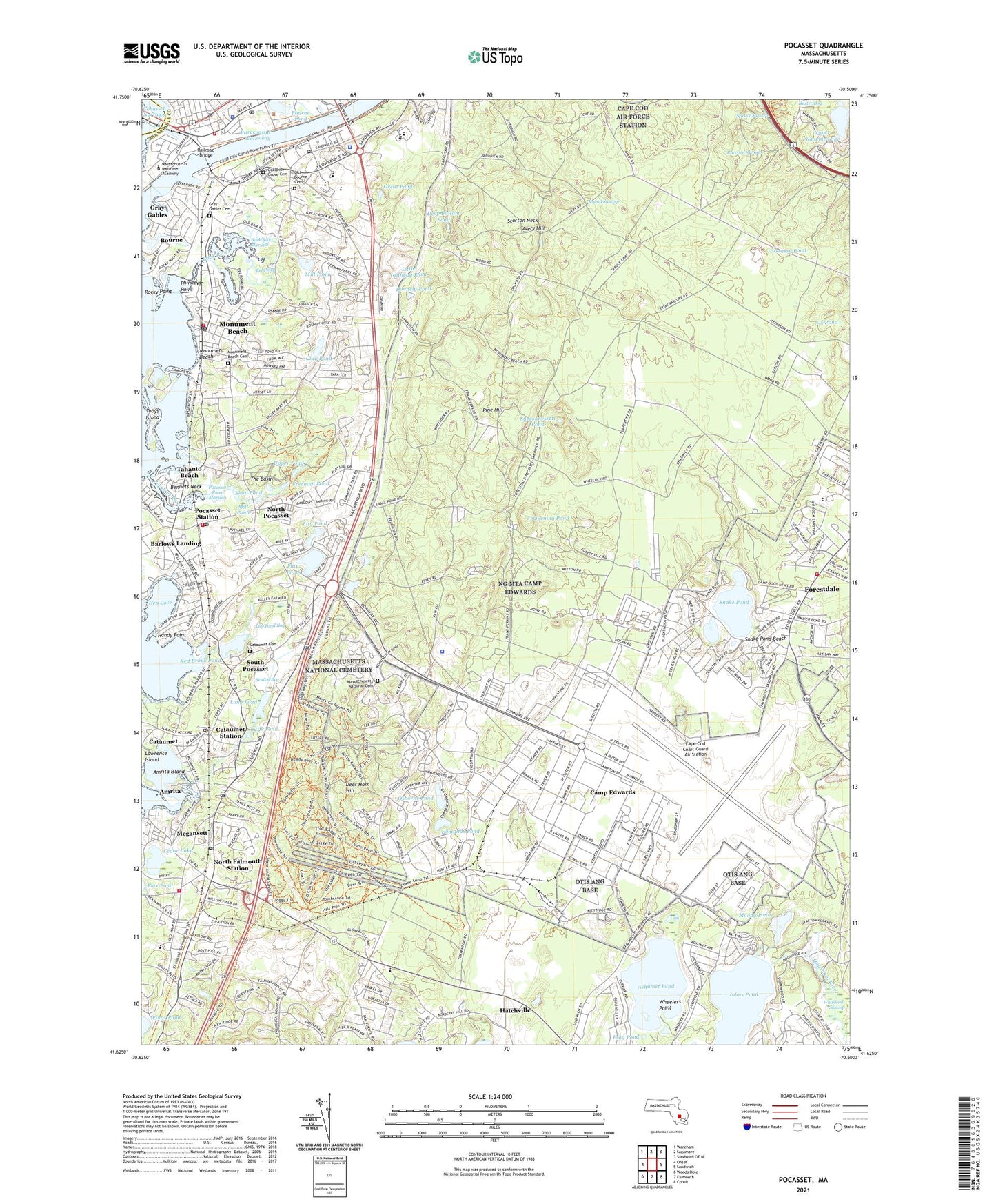
2024 topographic map quadrangle Pocasset in the state of Massachusetts. Scale: 1:24000. Based on the newly updated USGS 7.5' US Topo map series, this map is in the following counties: Barnstable, Plymouth. The map contains contour data, water features, and other items you are used to seeing on USGS maps, but also has updated roads and other features. This is the next generation of topographic maps. Printed on high-quality waterproof paper with UV fade-resistant inks.
Quads adjacent to this one:
West: Onset
Northwest: Wareham
North: Sagamore
Northeast: Sandwich OE N
East: Sandwich
Southeast: Cotuit
South: Falmouth
Southwest: Woods Hole
This map covers the same area as the classic USGS quad with code o41070f5.
Contains the following named places: Amrita, Amrita Island, Aptucxet Trading Post, Ashimuit, Ashumet Pond, Avery Hill, Back River, Back River Marshes, Ballymeade Golf Course, Barnstable County Hospital, Barnstable County Sheriff's Office, Beaton Bog, Bennets Neck, Bourne, Bourne Census Designated Place, Bourne Fire Department Station 1 Headquarters, Bourne Fire Department Station 2, Bourne Fire Department Station 4, Bourne Junior High School, Bourne Police Department, Bourne Pond, Bourne Post Office, Buzzards Bay, Buzzards Bay Post Office, Camp Edwards, Camp Edwards Heliport, Camp Goodwill, Campbell School, Cape Cod Coast Guard Air Station, Cataumet, Cataumet Cemetery, Cataumet Methodist Church, Cataumet Pier, Cataumet Post Office, Cataumet Station, Cedar Lake, Clay Pond, Coast Guard Air Station Cape Cod, Cohasset Narrows, Colonel James P Lyle Middle School, Cuffs Pond, Deep Bottom Pond, Deer Horn Hill, Dexter Bog, Donnely Pond, Edmunds Pond, Edward C Stone Middle School, Eel Pond, Falmouth Fire Station 3, Flax Pond, Forestdale Census Designated Place, Freeman Pond, Frog Pond, General Leonard Wood Homestead, Grassy Pond, Gray Gables, Gray Gables Cemetery, Great Pond, Grover Cleveland House Site, Handy Point, Hatchville, Hen Cove, James F Peebles Elementary School, Johns Pond, Jonathan Bourne Library, Lawrence Island, Lily Pond, Lily Pond Bog, Little Halfway Pond, Long Pond, Massachusetts Maritime Academy, Massachusetts Military Reservation, Massachusetts National Cemetery, Massachusetts State Police Bourne Barracks, Megansett, Mill Pond, Monument Beach, Monument Beach Cemetery, Monument Beach Census Designated Place, Monument Beach Post Office, Monument River, Moody Pond, North Falmouth, North Falmouth Elementary School, North Falmouth Post Office, North Falmouth Station, North Pocasset, Oakland Grove Cemetery, Old Bourne Cemetery, Opening Pond, Osborne Pond, Otis Memorial School, Ox Pond, Phinneys Harbor, Phinneys Point, Pine Hill, Pocasset, Pocasset Golf Club, Pocasset Iron Works, Pocasset Post Office, Pocasset River, Pocasset Station, Pocosset River, Pucasset River Marshes, Raccoon Swamp, Railroad Bridge, Red Brook, Red Brook Pond, Red Brook Pond Dam, Rocky Point, Round Swamp, Saint Margaret Regional School, Sandwich Fire Department Station 3, Scorton Neck, Shop Pond, Snake Pond, Snake Pond Beach, South Pocasset, Spruce Swamp, Squeteague Harbor, Succonnessett Pond, Tahanto Beach, Taylor Point, The Basin, The Chamberlain House, The Perry Hayse House, Tobys Island, Town of Bourne, Turtle Pond, Upper Pond, Upper Shawme Lake, US Coast Guard Morale Well-Being and Recreation Library, Waldorf School - Cape Cod, Weeks Pond, Wenaumet Station, Wheelers Point, Whitcomb Swamp, ZIP Codes: 02534, 02542, 02553, 02556, 02559, 02644