MyTopo
Plymouth Massachusetts US Topo Map
Couldn't load pickup availability
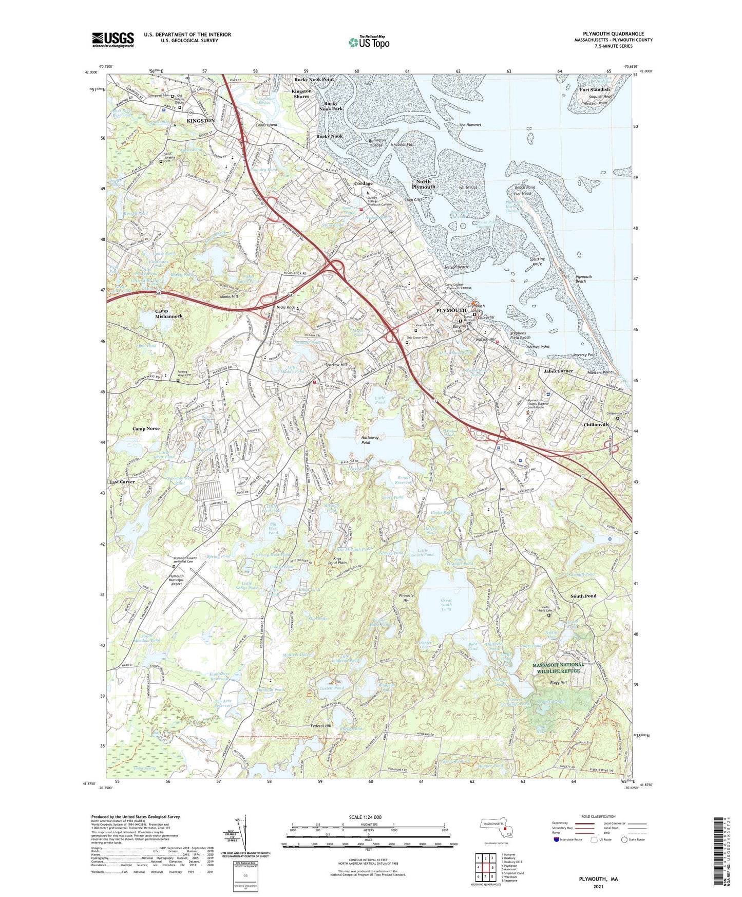
2024 topographic map quadrangle Plymouth in the state of Massachusetts. Scale: 1:24000. Based on the newly updated USGS 7.5' US Topo map series, this map is in the following counties: Plymouth. The map contains contour data, water features, and other items you are used to seeing on USGS maps, but also has updated roads and other features. This is the next generation of topographic maps. Printed on high-quality waterproof paper with UV fade-resistant inks.
Quads adjacent to this one:
West: Plympton
Northwest: Hanover
North: Duxbury
Northeast: Duxbury OE E
East: Manomet
Southeast: Sagamore
South: Wareham
Southwest: Snipatuit Pond
This map covers the same area as the classic USGS quad with code o41070h6.
Contains the following named places: Arms House Pond, Arms House Pond Dam, Bates Park, Beach Point, Big West Pond, Billington Ledge, Billington Sea, Billington Sea Dam, Black Cat Brook, Boot Pond, Bradford-Union Street Historic District, Brewster Gardens, Briggs Reservoir, Briggs Reservoir Dam Number 1, Burial Hill Cemetery, Burton Park, Burying Hill, Camp Mishannock, Camp Norse, Cedar Swamp, Cherry Pond, Chiltonville, Chiltonville Cemetery, Clear Pond, Colbys Pond, Coles Hill, Cole's Hill Sarcophagus, Commonwealth Park, Continental Camp of America Dam Number 1, Cooks Island, Cooks Pond, Cooks Pond Dam, Cordage, Cordage Park Marketplace Shopping Center, Cranberry Mall, Cranberry World Visitors Center, Crooked Pond, Curlew Pond, Cushmans Pond, Darby Pond, Darby Pond Outlet, Darby Pond West Outlet Dam, Delano's Wharf, Dunham Pond, Duxbury Pier Light, Duxbury Pier Lighthouse, Eel River, Eight Acre Reservoir, Eight Acre Reservoir Dam, Ellis Haven Campgrounds, Ellis Ponds, Elm Street on Jones River Reservoir, Evergreen Cemetery, Federal Hill, First Brook, Flagg Hill, Fort Standish, Foundry Pond, Foundry Pond Dam, Fresh Meadow Pond, Fresh Meadow Pond Number 1 Dam, Furnace Brook, Furnace Pond, Goose Point Channel, Goose Pond, Grassy Pond, Grassy West Pond, Grays Beach Park, Great Mink Hole, Great Snake Pond, Great South Pond, Gunners Exchange Pond, Hallfield Pond, Halls Brook, Harlow Pond, Hathaway Point, Hedges Pond, Hedges Wharf, High Cliff, Holmes Playground Dam, Holmes Point, Hooper Pond, Hoyts Pond, Ichabods Flat, Independence Mall Shopping Center, Island Pond, Jabez Corner, Jenkins Hole, Jenney Grist Mill, Jenney Pond, Jones River Marshes, Jones River Reservoir, Jones River Shipyard, Jones River Wapping Road Dam, Jordan Hospital Heliport, Kings Pond, Kingston, Kingston Census Designated Place, Kingston Shores, Kingston-Route 3 Station, Kngs Pond Plain, Leach Pond, Little Clear Pond, Little Micajah Pond, Little Mink Hole, Little Muddy Pond, Little Pond, Little Pratts Pond, Little Sabys Pond, Little Smelt Pond, Little Snake Pond, Little South Pond, Little West Pond, Little Widgeon Pond, Lout Pond, Lucas Pond, Lyon Pond, Manters Hole, Manters Point, Massachusetts State Pier, Massasoit National Wildlife Refuge, Massasoit Statue, Mayflower II Museum, Micajah Pond, Monks Hill, Morton Park, Muddy Pond, Narragansett Pond, National Monument to the Forefathers, Negro Pond, Nelson Beach, Nelson Street Recreation Area, Nicks Rock, No Bottom Pond, North Plymouth, North Plymouth Census Designated Place, North Plymouth Station, Oak Grove Cemetery, Old Burying Ground, Parting Ways Cemetery, Patuxet, Pickerel Cove, Pier Head, Pilgrim Hill Marketplace Shopping Center, Pilgrim Maiden Statue, Pilgrim Mother Statue, Pinehurst Mobile Home Village, Pinewood Lodge Campground, Pinewood Lodge Trailer Park, Pinnacle Hill, Plimoth Plaza, Plymouth, Plymouth Bay Winery, Plymouth Beach, Plymouth Census Designated Place, Plymouth Colony Winery, Plymouth County, Plymouth County Cemetery, Plymouth County Farm, Plymouth Harbor, Plymouth Harbor Channel, Plymouth Industrial Park, Plymouth Mobile Estates, Plymouth Municipal Airport, Plymouth Rock, Plymouth Rock Yacht Club, Plymouth Rod and Gun Club, Plymouth Station, Plymouth Town Wharf, Plymouth Village Historic District, Plymouth Yacht Club, Pond Hole, Poverty Point, Powder Horn Pond, Rocky Nook, Rocky Nook Park, Rocky Nook Point, Rocky Pond, Round Hole, Russell Mill Pond Seaplane Base, Russell Millpond, Russell Millpond Dam, Russell Pond, Russell Pond Dam, Saint Joseph's Cemetery, Saquich Head, Sawmill Pond, Second Brook, Silvia Place Pond Dam, Sly Ponds, Smelt Brook, Soules Pond, South Channel Range Light, South Meadow Pond, South Meadow Pond Dam, South Pond, South Pond Cemetery, South Triangle Pond, Sparrow Hill, Splitting Knife, Splitting Knife Channel Range Light, Spooner Pond, Spring Pond, Squirrel Run Country Club, Standish Mill Pond Dam, Standish Plaza Shopping Center, Stephens Field, Stephens Field Beach, Stone Pond, Ten Acre Reservoir, Ten Acre Reservoir Dam, The Nummet, Town Brook, Town Brook Park, Town Brook Reservoir, Town of Kingston, Trask Pond, Triangle Pond, Turtle Pond, Tussock Brook, Village Landing, Village Landing Marketplace Shopping Center, Village West Shopping Center, Vine Hills Cemetery, Warren Cove, Watson Hill, West Pond Heliport, Western Point, White Flat, Widgeon Pond, William Bradford Statue, Wolf Pond, ZIP Codes: 02330, 02360, 02364