MyTopo
Lapeer Michigan US Topo Map
Couldn't load pickup availability
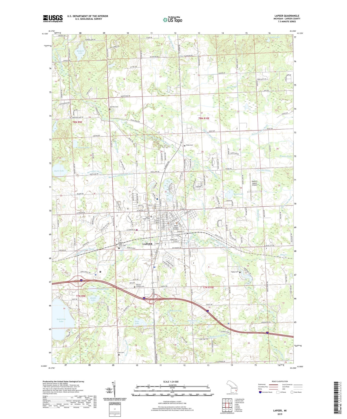
2023 topographic map quadrangle Lapeer in the state of Michigan. Scale: 1:24000. Based on the newly updated USGS 7.5' US Topo map series, this map is in the following counties: Lapeer. The map contains contour data, water features, and other items you are used to seeing on USGS maps, but also has updated roads and other features. This is the next generation of topographic maps. Printed on high-quality waterproof paper with UV fade-resistant inks.
Quads adjacent to this one:
West: Elba
Northwest: Columbiaville
North: Barnes Lake
Northeast: North Branch
East: Attica
Southeast: Thornville
South: Metamora
Southwest: Hadley
This map covers the same area as the classic USGS quad with code o43083a3.
Contains the following named places: Anrook Park, Audubon Park, Bethesda Lutheran Home, Bishop Kelley Catholic School, Calvary Bible Church, Camp O'Fair Winds, Camp Sherwood, Carpenters Station, Chateau Pines Lake Mobile Home Park, Chatfield School, Christ the King Lutheran Church, City of Lapeer, Clark Cemetery, Clover School, Community of Christ Church, Cornerstone Christian Fellowship, Cramton Elementary School, Cramton Park, Crestview Manor Mobile Home Park, Cutting Drain, Davenport Drain, Davis Lake, Dupont-Lapeer Airport, East Anrook Park, Elva Lynch Elementary School, Evans Drain, Faith Christian Church, Farmers Creek, Ferguson Convalescent Home, First Baptist Church, First Presbyterian Church, Gibbons Drain, Grace Baptist Church, Grace Episcopal Church, Grass Lake, Grass Lake Trail, Greenwood School, Hamilton Drain, Hewson Lanoe Drain, Higley Cemetery, Hilltop Campground, Horton Lake, Hunters Creek, Hunters Creek Drain, Immaculate Conception Church, Irwin School, Jehovah's Witnesses, King Drain, Lapeer, Lapeer Apostolic Church, Lapeer Assembly of God Church, Lapeer Church of Christ, Lapeer Church of God, Lapeer Church of the Nazarene, Lapeer City Hall, Lapeer Community Church, Lapeer Country Club, Lapeer County Courthouse, Lapeer County Emergency Medical Services Station 1, Lapeer County Emergency Medical Services Station 4, Lapeer County Historical Marker, Lapeer County Historical Society Museum, Lapeer County Sheriff's Office, Lapeer District Library, Lapeer East High School, Lapeer Fire and Rescue Department, Lapeer Free Methodist Church, Lapeer International Dragway, Lapeer Meadows Mobile Home Park, Lapeer Medical Associates, Lapeer Police Department, Lapeer Post Office, Lapeer Public Library Historical Marker, Lapeer State Home, Lapeer State Home Cemetery, Lapeer Station, Lapeer Township Police Department, Lapeer West High School, Liberty Park, Maple Grove Christian Church, Maple Grove School, Marguerite de Angeli Library, May and White Drain, Mayfield and Oregon Drain, Mayfield School, McKeen Lake, McLaren Community Medical Center, Mclaren Lapeer Region Hospital, Michigan State Police District 3 Lapeer Post 34, Middle Lake, Miller Drain, Millville Cemetery, Millville Church, Misener School, Mott Community College-Lapeer, Mount Hope Cemetery, Mount Loretto Cemetery, Mud Lake, Murlin Lake Drain, Nelson Drain, Nepessing Lake, New Beginnings Family Church, Oregon Post Office, Pass Lake, Peasley Drain, Pine Creek, Plum Creek Drain, Reamer School, Reid Drain, Rolling Hills Golf Club, Rood Lake, Rood Lake Drain, Rotary Park, Rudner Drain, Saint Matthew's Anglican Church, Saint Paul Lutheran Church, Saint Paul Lutheran School, Schickler Elementary School, Seventh-Day Adventist Church, Stiles Cemetery, Suncrest Hospital, The Display Garden on Suncrest, Thumb Correctional Facility, Town Line Drain, Township of Lapeer, Township of Mayfield, Trinity United Methodist Church, Turrill School, Tuttle House Historical Marker, Valentine School, Vasa Country Club, Watertower Travel Trailer Park, Whelock Lake, White Drain, Whitehead Lake, Wilger Drain, WMPC-AM (Lapeer), Woodside School, WWGZ-AM (Lapeer), Youngs Lake, Zemmer Junior High School, ZIP Code: 48446