MyTopo
Portland South Michigan US Topo Map
Couldn't load pickup availability
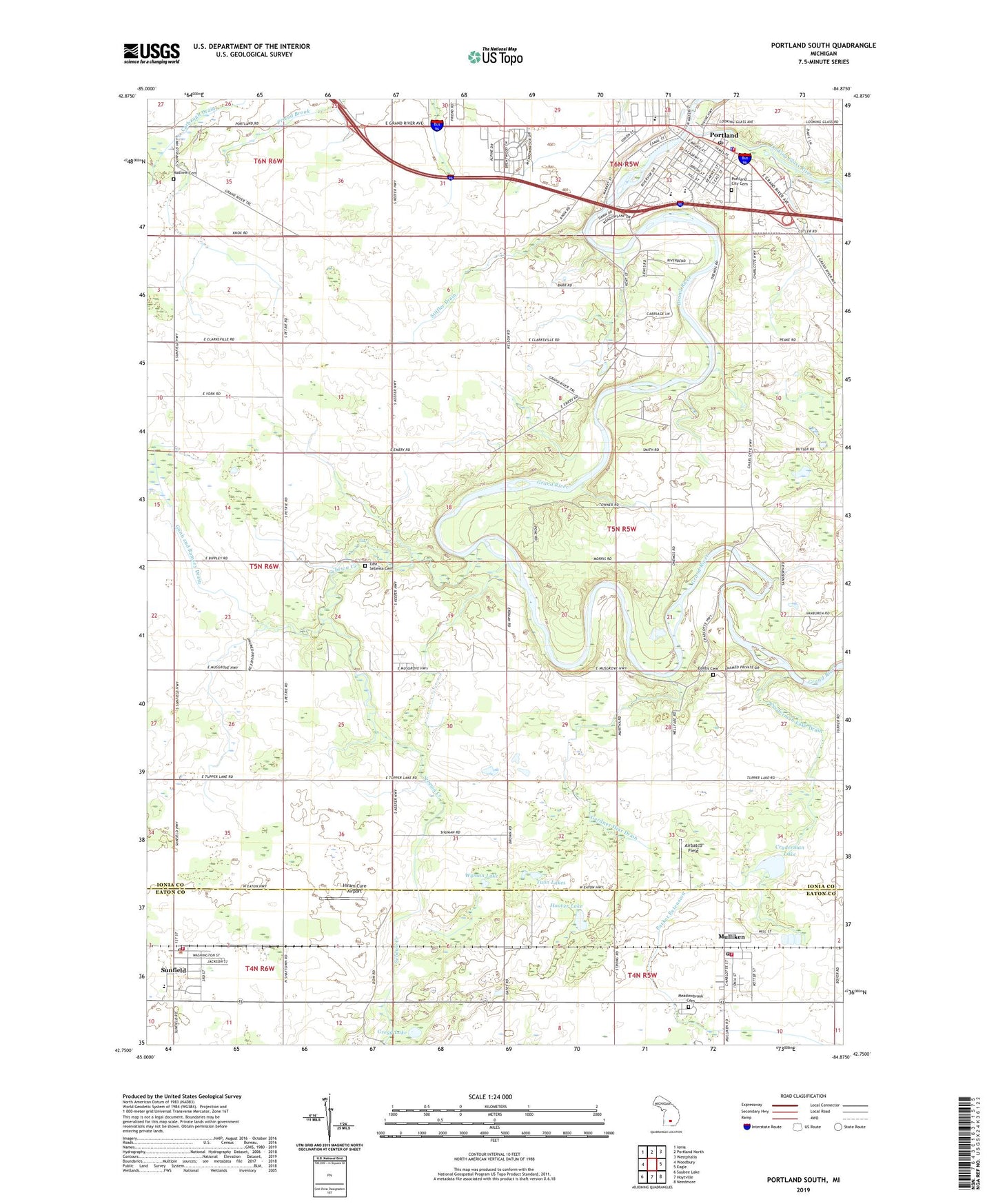
2023 topographic map quadrangle Portland South in the state of Michigan. Scale: 1:24000. Based on the newly updated USGS 7.5' US Topo map series, this map is in the following counties: Ionia, Eaton. The map contains contour data, water features, and other items you are used to seeing on USGS maps, but also has updated roads and other features. This is the next generation of topographic maps. Printed on high-quality waterproof paper with UV fade-resistant inks.
Quads adjacent to this one:
West: Woodbury
Northwest: Ionia
North: Portland North
Northeast: Westphalia
East: Eagle
Southeast: Needmore
South: Hoytville
Southwest: Saubee Lake
This map covers the same area as the classic USGS quad with code o42084g8.
Contains the following named places: Airbatco Field, Alton Park, Bible Missionary Church, Brush Street Park, Church of the Nazarene, City of Portland, Cryderman Lake, Cryderman Lake Drain, Danby Cemetery, Danby Post Office, East Sebewa Cemetery, Faith Bible Church, Family Health Center-Portland, First Baptist Church, First Congregational Church, Gardner Hiar Drain, Grand Army of the Republic Hall Historical Marker, Grange Hall, Gregg Lake, Gunn and Ramsey Drain, Hiram Cure Airport, Hoover Lake, Jeffrey Post Office, Kent Corners, Looking Glass River, Mathew Cemetery, Meadowbrook Cemetery, Mulliken, Mulliken District Library, Mulliken Post Office, Mulliken Station, Mulliken United Methodist Church, Oakwood Elementary School, Parker Extension, Parkview Estates Mobile Home Park, Portland, Portland Ambulance Service, Portland Church, Portland City Cemetery, Portland City Hall, Portland District Library, Portland Family Care Center, Portland Fire Department, Portland Middle School, Portland Police Department, Portland Post Office, Portland State Game Area, Powers Park, Roxand Township Fire Department, Saint Andrew Lutheran Church, Saint Patrick's Church, Sebewa Corners, Sebewa Creek, Sebewa Post Office, Seventh Day Adventist Church, Stiffler Drain, Sunfield, Sunfield District Library, Sunfield Elementary School, Sunfield Fire District, Sunfield Police Department, Sunfield Post Office, Sunfield Station, Sunfield Township Hall, Sunset Ridge Mobile Home Park, Sunset View Mobile Home Park, Thompson Field, Township of Danby, Twin Lakes, United Methodist Church, Village of Mulliken, Village of Sunfield, William Toan Park, Willow Wood Golf Course, Wyman Lake, ZIP Codes: 48875, 48890