MyTopo
Smiths Creek Michigan US Topo Map
Couldn't load pickup availability
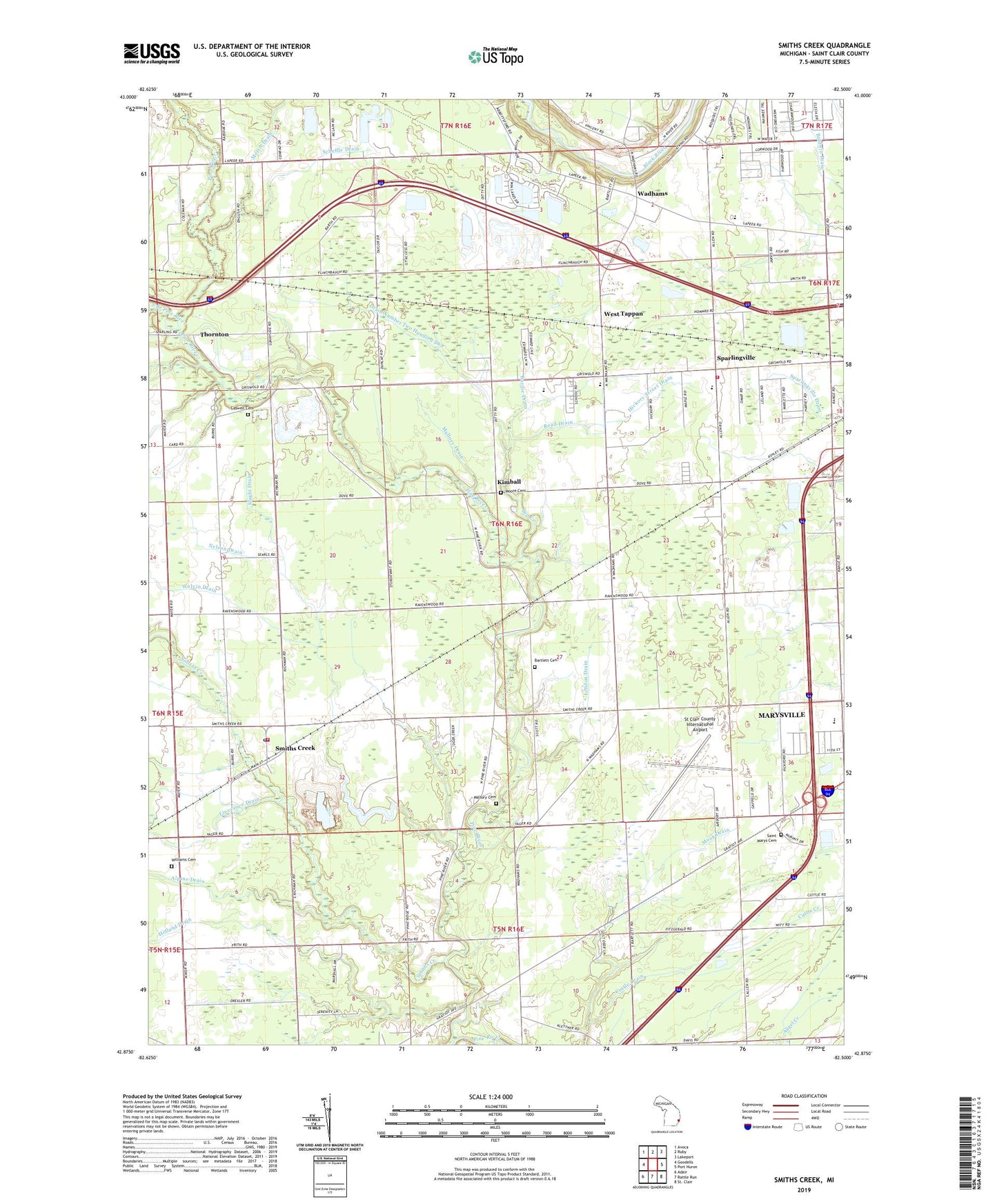
2023 topographic map quadrangle Smiths Creek in the state of Michigan. Scale: 1:24000. Based on the newly updated USGS 7.5' US Topo map series, this map is in the following counties: St. Clair. The map contains contour data, water features, and other items you are used to seeing on USGS maps, but also has updated roads and other features. This is the next generation of topographic maps. Printed on high-quality waterproof paper with UV fade-resistant inks.
Quads adjacent to this one:
West: Goodells
Northwest: Avoca
North: Ruby
Northeast: Lakeport
East: Port Huron
South: Rattle Run
Southwest: Adair
This map covers the same area as the classic USGS quad with code o42082h5.
Contains the following named places: All Faiths Church, Alpine Drain, Bacon School, Bartlett Cemetery, Bethlehem Saving Temple, Big Creek, Burdie Drain, Burns Post Office, Burns Station, Caswell Cemetery, Community Baptist Church, Community Independent Baptist Church, Community of Christ-Wadhams, Cross Current Church, Crystal Lake, Cuttle Drain, Drain Number Two Hundred Two, Fore Lakes Golf Club, G Lynn Campbell Library, Hickory Street Drain, Holland Drain, Holy Redeemer Lutheran Church, Holy Rosary Church, Horizon Outlet Center of Port Huron Shopping Center, Indianwood School, Johnson Field, Kimball, Kimball Calvary Gospel Church, Kimball Post Office, Kimball School, Kimball Station, Kimball Township Fire Department Station 1, Kimball Township Fire Department Station 2, Kimball Township Park, Life in Christ Church, Life in Christ Fellowship, Liverance Drain, London Drain, Mallory Cemetery, Mallory Drain, Mercy Family Care, Moore Cemetery, Morris Drain, Nelson Drain, New Hope All Nation Apostolic Holiness Church, New Life Christian Academy, Pine Lake, Port Huron KOA Campgrounds, Rattle Run, Read Drain, Saint Marys Cemetery, Scheffle Drain, Slaght Drain, Smiths Creek, Smiths Creek Community Church, Smiths Creek Post Office, Smiths Creek Station, Somerset Meadows Mobile Home Park, South Branch Pine River, Sparlingville, Sparlingville Baptist Church, Sparlingville Drain, Sparlingville School, Sparlingville Wesleyan Church, St Clair County International Airport, The Lakes Mobile Home Park, Thornton, Thornton Post Office, Thornton Station, Township of Kimball, Trent Lake, Tri - Hospital Emergency Medical Services Station 5, Wadhams, Wadhams Baptist Church, Wadhams Post Office, Wadhams Station, West Tappan, Williams Cemetery, Wolvin Drain, ZIP Code: 48074