MyTopo
Grand Rapids Minnesota US Topo Map
Couldn't load pickup availability
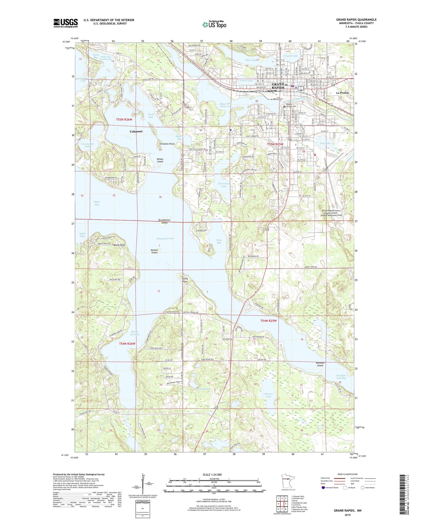
2022 topographic map quadrangle Grand Rapids in the state of Minnesota. Scale: 1:24000. Based on the newly updated USGS 7.5' US Topo map series, this map is in the following counties: Itasca. The map contains contour data, water features, and other items you are used to seeing on USGS maps, but also has updated roads and other features. This is the next generation of topographic maps. Printed on high-quality waterproof paper with UV fade-resistant inks.
Quads adjacent to this one:
West: Siseebakwet Lake
Northwest: Cohasset West
North: Cohasset East
Northeast: Bovey
East: La Prairie
Southeast: Split Hand Lake
South: Mountain Ash Lake
Southwest: Big Thunder Peak
This map covers the same area as the classic USGS quad with code o47093b5.
Contains the following named places: Acheson Mobile Home Village, American Legion Memorial Park, Apostolic Revival Center, Assembly of God Church, Bahai Faith, Best Mobile Home Park, Birch Cove Resort and Campground, Blandin Dam, Blandin Mississippi River Park, Blandin Park, Blandin Private Cemetery, Cavanaugh Lake, Central Square Mall, Chisholm Point, Christ Episcopal Church, Christian Community School, Church of Jesus Christ of Latter Day Saints, Church of the Nazarene, City of Grand Rapids, Community Presbyterian Church, Crystal Lake, D A Grossendorf Park, Drumbeater Island, Faith Baptist Church, Fellowship of Believers, First Church of God, First Evangelical Lutheran Church, Forest History Center, Forest Lake, Forest Lake Elementary School, Full Gospel Church, Grace Bible Church, Grace Christian School, Grand Itasca Clinic and Hospital, Grand Rapids, Grand Rapids Air Force Station, Grand Rapids Alliance Church, Grand Rapids Baptist Church, Grand Rapids Clinic, Grand Rapids Clinic East, Grand Rapids Evangelical Church, Grand Rapids Fire Department North Side Station, Grand Rapids Fire Department South Side Station, Grand Rapids High School, Grand Rapids Middle School, Grand Rapids Police Department, Grand Rapids Post Office, Grand Rapids Public Library, Grand Rapids Speedway, Grand Rapids Wayside Park, Grand Rapids/Itasca County Airport-Gordon Newstrom Field, Hale Lake, Horseshoe Lake, Huhn Addition Mobile Home Court, Itasca County Courthouse, Itasca County Fairgrounds, Itasca County Jail, Itasca County Nursing Home, Itasca County Sheriff's Office, Itasca County Sherrif's Office, Jay Gould Lake, Jehovah's Witnesses Congregation, Judy Garland Children's Museum, King Bay, Lake Pokegama Rest Area, Lake Sylvan, Lakeview Terrace, Leisure Hills Care Center, Lily Lake, Little Jay Gould Lake, Little Pokegama Lake, Meds - 1 Ambulance Service, Meyers Bay, Minnesota Interagency Fire Center, Moose Point, Munzer Lake, Murhunt Park, Murphy Elementary School, Nesbitt Island, New Spirit Woman's Clinic, North Star Moblie Home Park, Northern Pines Ortho Clinic, Oakland Estates Mobile Home Park, Oakland Park, Our Redeemer Lutheran Church, Paper Mill Reservoir, Pokegama Golf Course, Pokegama Lake, Pokegama Lake Dam, Pokegama Plaza, Pokegama Reservoir, Poole Bay, Riverside Park, Riverview School, Saint Joseph's Catholic Church, Saint Joseph's Catholic Grade School, Saint Luke's Evangelical Lutheran Church, Salem Lutheran Brethren Church, Seventh-Day Adventist Church, Sherry Arm Bay, Southwest Elementary School, Stokey Lake, Stony Point, Sugar Bay, Sugar Brook, Sylvan Lake, Tioga Mine, Township of Grand Rapids, Township of Harris, Turtle Bay, Unitarian Fellowship Church, United Methodist Church, Wagon Wheel Mobile Home Park, Wendigo Arm Bay, Wendigo Island, Wilder Island, Willow Park, Zion Evangelical Lutheran Church, ZIP Code: 55744