MyTopo
Corinth Mississippi US Topo Map
Couldn't load pickup availability
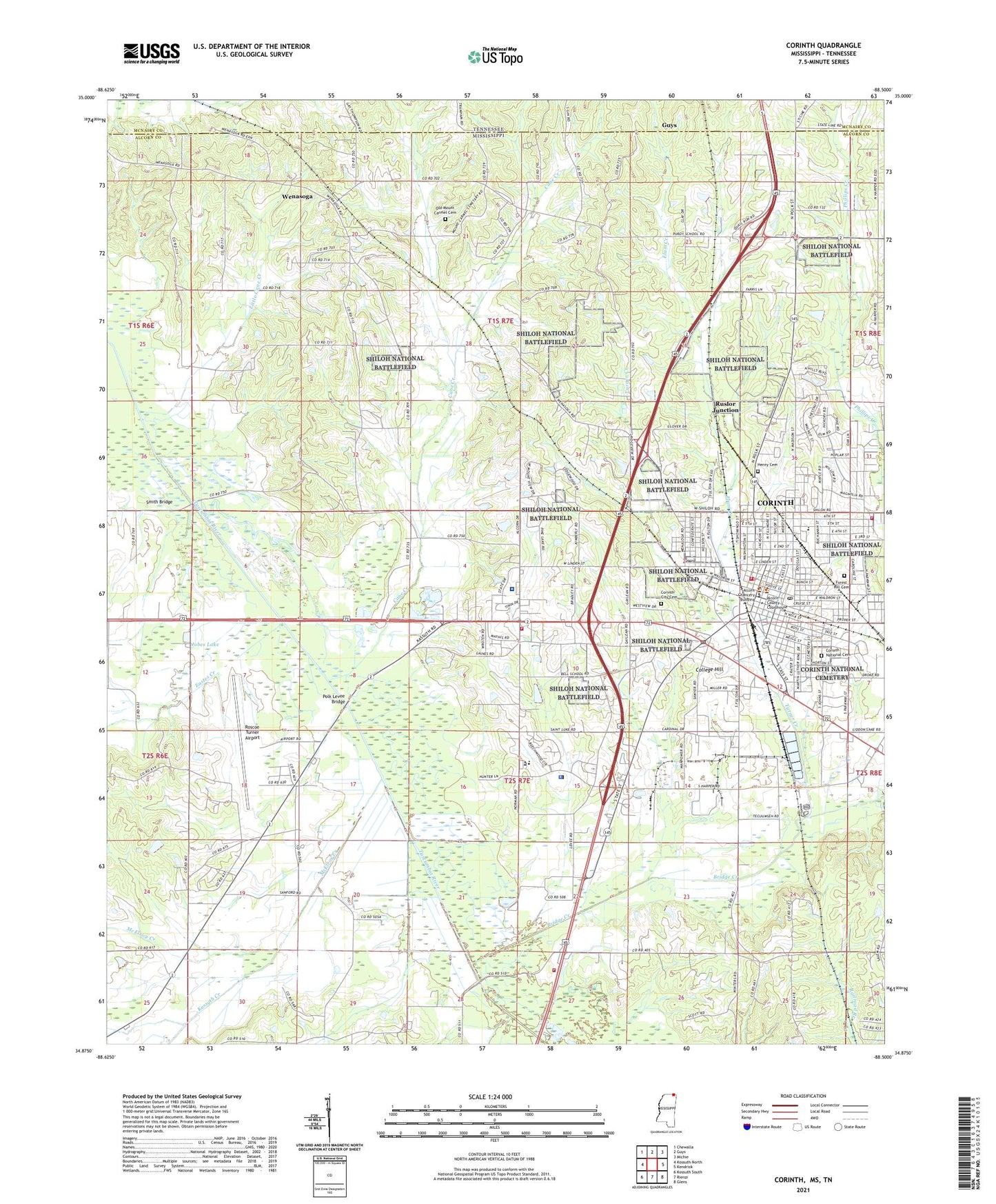
2024 topographic map quadrangle Corinth in the state of Mississippi. Scale: 1:24000. Based on the newly updated USGS 7.5' US Topo map series, this map is in the following counties: Alcorn, McNairy. The map contains contour data, water features, and other items you are used to seeing on USGS maps, but also has updated roads and other features. This is the next generation of topographic maps. Printed on high-quality waterproof paper with UV fade-resistant inks.
Quads adjacent to this one:
West: Kossuth North
Northwest: Chewalla
North: Guys
Northeast: Michie
East: Kendrick
Southeast: Glens
South: Rienzi
Southwest: Kossuth South
Contains the following named places: Alcorn County, Alcorn County Correctional Center, Alcorn County Courthouse, Alcorn County Health Center, Alcorn County Vocational Center, Anderson, Antioch Church, Battery B, Battery C, Battery D, Battery Dillon, Battery E, Battery F, Battery Lathrop, Battery Madison, Battery Phillips, Battery Power, Battery Robinett, Battery Tannrath, Battery Williams, Bell School, Bridge Creek, Buffalo Hole, Calvary Baptist Church, Calvary Pentecostal Church, Cane Creek, City of Corinth, City Road Temple Christian Methodist Episcopal Church, College Hill, Community Hospital, Concord School, Corinth, Corinth Arsenal, Corinth City Cemetery, Corinth City Hall, Corinth City Park, Corinth Fire Department Station 1, Corinth Fire Department Station 2, Corinth Fire Department Station 3, Corinth Industrial Park, Corinth Junior-Senior High School, Corinth National Cemetery, Corinth Police Department, Corinth Post Office, Corinth Public Library, Corinth Sanitarium, Corona Female College, Curlee Museum, Dennistown School, East Corinth Baptist Church, East Corinth Church of Christ, East Corinth Elementary School, East Fifth Street Missionary Baptist Church, Eastes Creek, Elam Creek, Fillmore Street Presbyterian Church, First Assembly of God Church, First Baptist Church, First Pentecostal Church, First Presbyterian Church, First United Methodist Church, Foote Street Church of Christ, Forest Hill Cemetery, Gaines Chapel United Methodist Church, Gospel Tabernacle, Henry Cemetery, Holly Baptist Church, Holly School, Jobes Lake, Johns Street Park, King Street African Methodist Episcopal Church, Kossuth Creek, Little Cane Creek, Little Zion Missionary Baptist Church, Little Zion School, Macedonia Missionary Baptist Church, Magnolia Regional Health Center, McElroy Creek, Meiggs Street Church of Christ, Mingo City, Mount Carmel Methodist Church, Mount Moriah Methodist Episcopal Church, North Corinth Baptist Church, Northeast Mississippi Museum, Old Mount Carmel Cemetery, Pleasant Hill Church, Pleasant Hill School, Pleasant Hill United Methodist Church, Polk Levee Bridge, Purdy Road School, Roscoe Turner Airport, Rosenwald School, Ruslor Junction, Saint James Catholic Church, Saint Mark Baptist Church, Saint Pauls Episcopal Church, Saint Rest Missionary Baptist Church, Second Pentecostal Church, Shady Grove Church, Shady Grove Methodist Church, Shady Grove Mission, Smith Bridge, South Corinth Baptist Church, South Corinth Elementary School, Southside Methodist Church, Sumner School, Supervisor District 1, Supervisor District 4, Tate Street Baptist Church, Trinity Methodist Church, Turner Creek, Waldron Street Christian Church, Weedon Lake, Welcome Church, Wenasoga, Wenasoga Church of Christ, West Corinth, West Corinth Baptist Church, West Corinth Church of Christ, West Corinth Elementary School, West Corinth Pentecostal Church, Whitfield Plantation, ZIP Code: 38834