MyTopo
Lake Ozark Missouri US Topo Map
Couldn't load pickup availability
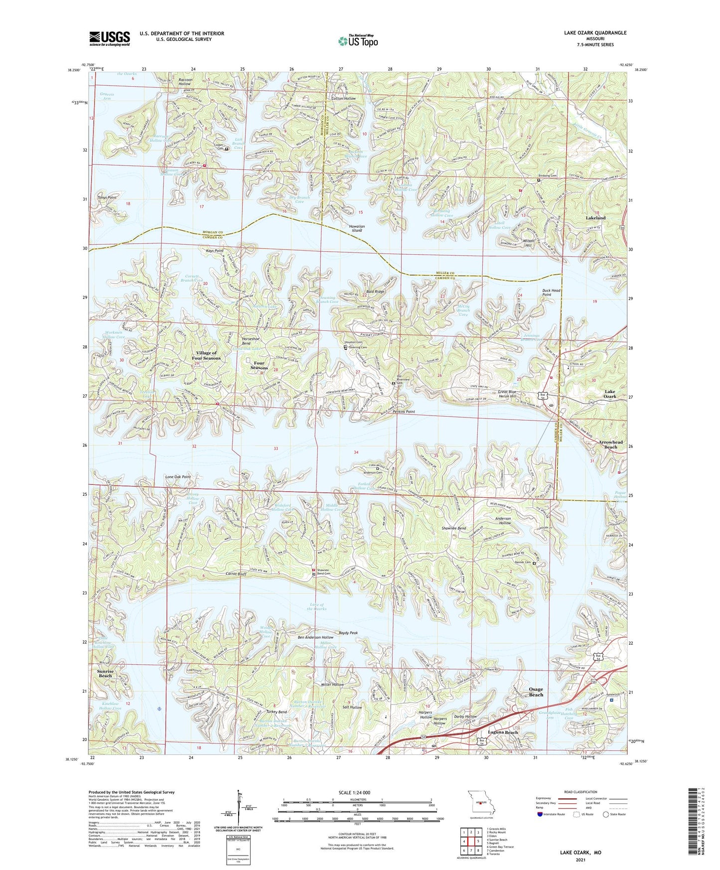
2021 topographic map quadrangle Lake Ozark in the state of Missouri. Scale: 1:24000. Based on the newly updated USGS 7.5' US Topo map series, this map is in the following counties: Camden, Miller, Morgan. The map contains contour data, water features, and other items you are used to seeing on USGS maps, but also has updated roads and other features. This is the next generation of topographic maps. Printed on high-quality waterproof paper with UV fade-resistant inks.
Quads adjacent to this one:
West: Sunrise Beach
Northwest: Gravois Mills
North: Rocky Mount
Northeast: Eldon
East: Bagnell
Southeast: Toronto
South: Camdenton
Southwest: Green Bay Terrace
This map covers the same area as the classic USGS quad with code o38092b6.
Contains the following named places: Anderson Cemetery, Anderson Hollow, Arrowhead, Arrowhead Beach, Autumn Lake, Autumn Lake Dam, Bagnell Dam, Bald Ridge, Banner Cemetery, Baydy Peak, Ben Anderson Hollow, Birdsong Cemetery, Birdsong Hollow Cove, Burton Duenke Lake Number 1 Dam, Burton Duenke Lake Number 2 Dam, Burton Duenke Lake Number 3 Dam, Burton Duenke Lake Number 5 Dam, Burton Duenke Lake Number 6 Dam, Burton Duenke Number 1 Reservoir, Burton Duenke Number 2 Reservoir, Burton Duenke Number 3 Reservoir, Burton Duenke Number 4 Dam, Carrot Bluff, City of Lake Ozark, City of Osage Beach, Cooper Cemetery, Cornett Branch Cove, Cotton Hollow, Darby Hollow, Davey Hollow Cove, Dogwood Hills Dam, Downing Branch Cove, Downing Cemetery, Dry Branch Cove, Duck Head Point, Eagles Roost Heliport, Fish Hatchery Cove, Forked Hollow Cove, Four Seasons, Good Oak Lake, Good Oak Lake Dam, Grand Glaize Shopping Center, Great Blue Heron Hill, Harpers Chapel, Harpers Hollow, Hawaiian Island, High Point Shopping Center, Horseshoe Bend, Houston Cemetery, Jackson Branch, Jackson Branch Cove, Jennings Branch Cove, Jobson Hollow Cove, Kays Point, Kinchlow Hollow Cove, Laguna Beach, Lake Ozark, Lake Ozark Fire Protection District Fire Boat, Lake Ozark Fire Protection District Station 1 Headquarters, Lake Ozark Fire Protection District Station 2, Lake Ozark Fire Protection District Station 3, Lake Ozark Post Office, Lakeland, Lick Branch Cove, Links Landing Seaplane Base, Little Kinchlow Hollow Cove, Lone Oak Point, Lotell Hollow Cove, Mansfield Forest State Wildlife Management Area, McCoy Branch Cove, Middle Hollow Cove, Miller Hollow, Miller Hollow Cove, Millstone Church, Mud Harbor Seaplane Base, Old Riverview Cemetery, Osage Beach Police Department, Osage Beach Post Office, Our Lady of the Lake Chapel, Perkins Point, Pogue Hollow Cove, Possum Hollow Cove, Raccoon Hollow, Raccoon Hollow Cove, Rocky Mount Fire Protection District Station 3, Salt Hollow, School of the Osage, Shawnee Bend, Shawnee Bend Cemetery, Stevens Banner Cemetery, Sunrise Beach Fire Department Station 3, Tan Tar A Resort Seaplane Base, Tonys Point, Treeline Lake, Treeline Lake Dam, Turkey Bend, Village of the Village of Four Seasons, Watson Hollow Cove, Wideford Hollow Cove, Wilson Hill, Woods Hollow Cove, Workmen Hollow Cove, ZIP Codes: 65049, 65065, 65079