MyTopo
Noel Missouri US Topo Map
Couldn't load pickup availability
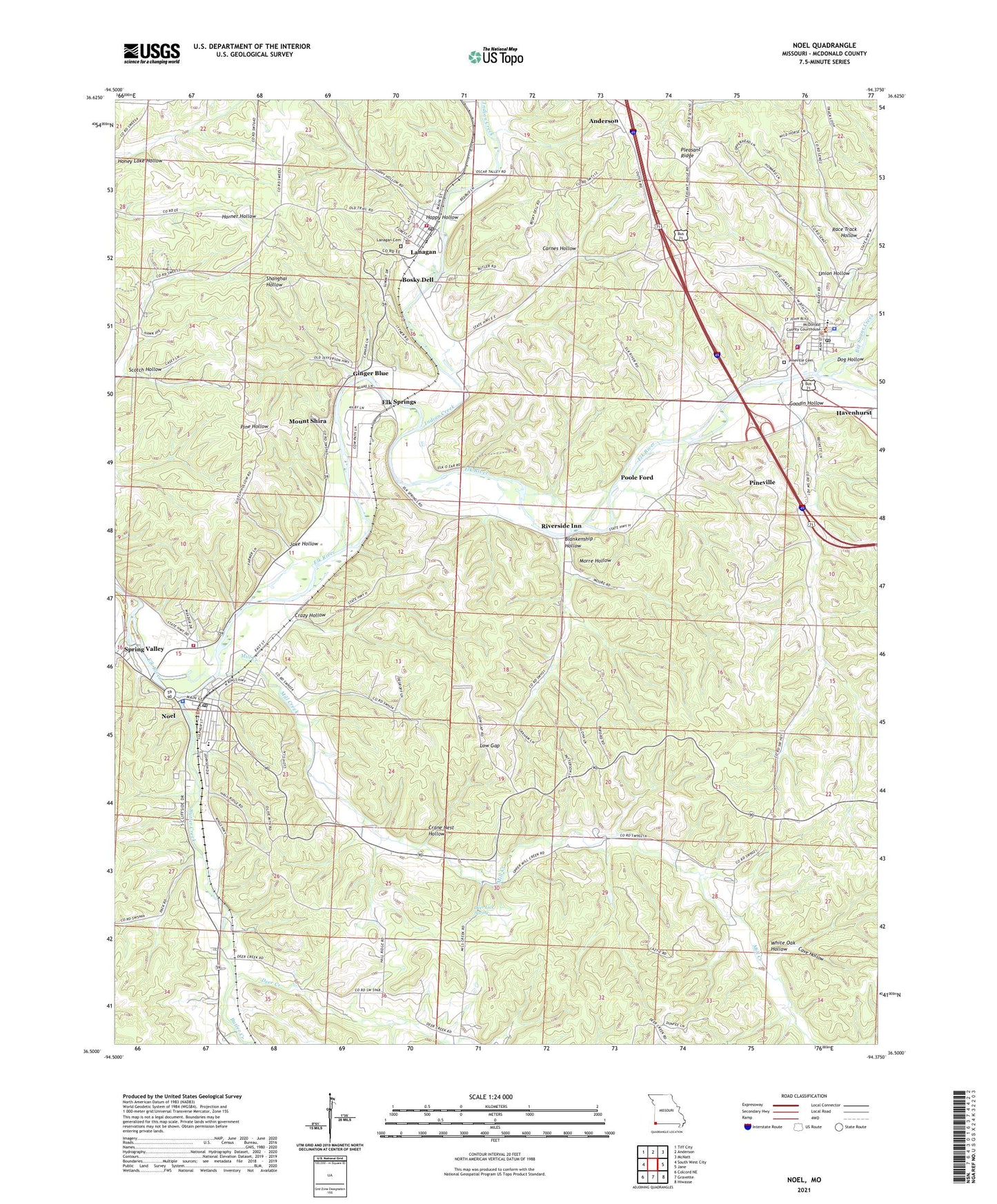
2021 topographic map quadrangle Noel in the state of Missouri. Scale: 1:24000. Based on the newly updated USGS 7.5' US Topo map series, this map is in the following counties: McDonald. The map contains contour data, water features, and other items you are used to seeing on USGS maps, but also has updated roads and other features. This is the next generation of topographic maps. Printed on high-quality waterproof paper with UV fade-resistant inks.
Quads adjacent to this one:
West: South West City
Northwest: Tiff City
North: Anderson
Northeast: McNatt
East: Jane
Southeast: Hiwasse
South: Gravette
Southwest: Colcord NE
This map covers the same area as the classic USGS quad with code o36094e4.
Contains the following named places: Armstrong Quarry, Big Sugar Creek, Blankenship Hollow, Bosky Dell, Butler Creek, Carnes Hollow, Cave Hollow, City of Noel, City of Pineville, Crane Nest Hollow, Crazy Hollow, Deer Creek, Deer Lick Spring, Dog Hollow, Elk Springs, Ginger Blue, Goodin Hollow, Happy Hollow, Indian Creek, Jake Hollow, Lanagan, Lanagan Post Office, Lanagan Tower State Public Hunting Grounds, Lanagan Volunteer Fire Department, Little Sugar Creek, Low Gap, Mc Donald County Sheriff's Office, Mill Creek, Mill Creek Church, Morre Hollow, Mount Shira, Mount Shira Elk River Public Access Area, Noel, Noel Elementary School, Noel Fire Department, Noel Police Department, Noel Post Office, Pineville, Pineville Elementary School, Pineville Marshal's Office, Pineville Post Office, Pineville Primary School, Pineville Volunteer Fire Department, Pleasant Ridge, Poole Ford, Quarry Track, Race Track Hollow, Riverside Inn, Scotch Hollow, Shadow Lake, Spring Valley, Town of Lanagan, Township of Elk River East, Township of Pineville Lanagan, Union Hollow, Village of Ginger Blue, White Oak Hollow, Yarnell Branch, ZIP Codes: 64847, 64854