MyTopo
Big Timber Montana US Topo Map
Couldn't load pickup availability
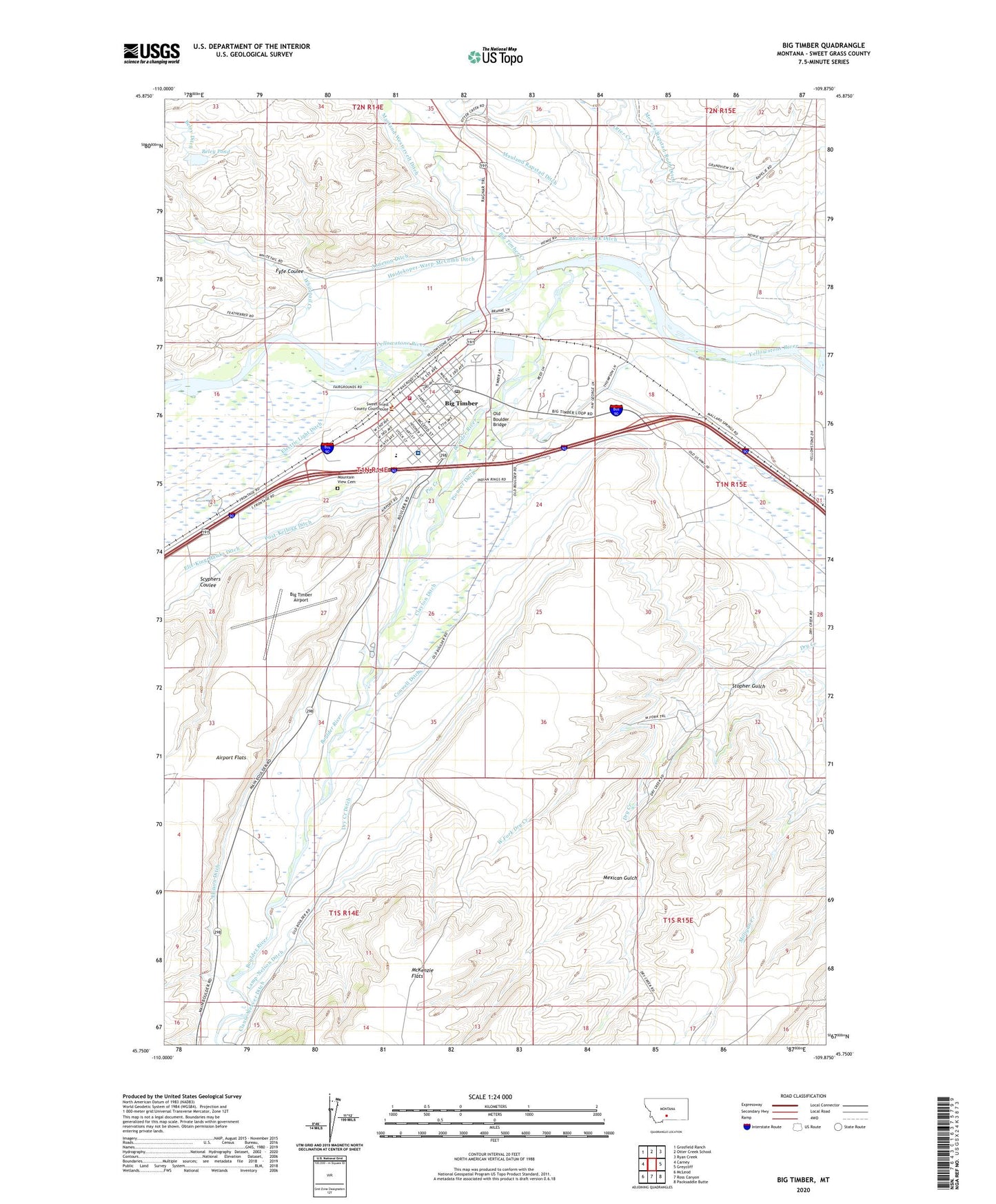
2024 topographic map quadrangle Big Timber in the state of Montana. Scale: 1:24000. Based on the newly updated USGS 7.5' US Topo map series, this map is in the following counties: Sweet Grass. The map contains contour data, water features, and other items you are used to seeing on USGS maps, but also has updated roads and other features. This is the next generation of topographic maps. Printed on high-quality waterproof paper with UV fade-resistant inks.
Quads adjacent to this one:
West: Carney
Northwest: Grosfield Ranch
North: Otter Creek School
Northeast: Ryan Creek
East: Greycliff
Southeast: Packsaddle Butte
South: Ross Canyon
Southwest: McLeod
This map covers the same area as the classic USGS quad with code o45109g8.
Contains the following named places: 01N14E10____01 Well, 01N14E11____01 Well, 01N14E11ACAA01 Well, 01N14E12____01 Well, 01N14E12CACB01 Well, 01N14E12CCAD01 Well, 01N14E13BBCD01 Well, 01N14E13BDCA01 Well, 01N14E13DAAC01 Well, 01N14E13DABD01 Well, 01N14E15BDBB01 Well, 01N14E15BDCB01 Well, 01N14E15DAAA01 Spring, 01N14E21AADC01 Well, 01N14E21DCDC01 Well, 01N14E23____01 Well, 01N14E23ACDD01 Spring, 01N14E23BDAB01 Well, 01N14E23BDAD01 Well, 01N14E23DBAC01 Well, 01N14E24AAAA01 Well, 01N14E24BBBA01 Spring, 01N14E24BBCD01 Well, 01N14E26DAAC01 Well, 01N14E27DDCB01 Well, 01N14E28BABD01 Well, 01N14E34ABDD01 Well, 01N14E34ADAB01 Well, 01N14E34ADDC01 Well, 01N14E34BDBA01 Spring, 01N15E07C___01 Well, 01N15E20B___01 Well, 01N15E29C___01 Well, 01N15E29DCAD01 Well, 01N15E31____01 Well, 01S14E02BAAA01 Well, 01S14E03BCAB01 Spring, 01S14E03BDBB01 Well, 01S14E10ADBB01 Well, 01S14E10BBCD01 Well, 01S14E10CAAD01 Well, 01S14E10CABD01 Well, 01S14E10CCAD01 Well, 01S14E11BBBD01 Spring, 01S14E15BBCC01 Well, 01S15E04ABCD01 Well, 01S15E06A___01 Well, 01S15E06ADCA01 Well, Arneson Ditch, Bailey-Clark Ditch, Beley Pond, Beley Pond Dam, Big Rock Fishing Access Site, Big Timber, Big Timber Airport, Big Timber Baptist Church, Big Timber Church of God, Big Timber City Hall, Big Timber Creek, Big Timber Evangelical Free Church, Big Timber Industrial Park, Big Timber Lutheran Church, Big Timber Police Department, Big Timber Post Office, Big Timber School, Big Timber Sewage Lagoon Dam, Big Timber Volunteer Fire Department, Bonanza or Bozeman Trail Historical Marker, Boulder River, Carnegie Public Library, Church of Christ, City of Big Timber, Clause Weaver Ditch, Clayton Ditch, Congregational Church, Conwell Ditch, Crazy Mountain Museum, Dry Creek Ditch, Dry Creek School, Duffy Trailer Court, Electric Light Ditch, Elis-King-Hawks Ditch, Ellison Ditch, Evangelical Church of North America, Featherbed Creek, Fire Island, Fyfe Coulee, Hogan Ditch, Huidekoper-Warp-McComb Ditch, K-W Feed and Grain Elevator, Lamp-Nelson Ditch, Lions Club Park, Mauland Rapstad Ditch, Mauland-Westervelt Ditch, Mexican Gulch, Meyers-Rapstad-Rudd Ditch, Mountain View Cemetery, Old Boulder Bridge, Otter Creek, Otter Creek Fishing Access Site, Overland Golf Course, Pig Creek, Pioneer Ditch, Pioneer Medical Center, Post-Kellogg Ditch, Rapelje Grain Company Elevator, Rudd Ditch, Saint Josephs Catholic Church, Saint Marks Episcopal Church, Scyphers Coulee, Seventh Day Adventist Church, Spring Creek Camp and Trout Ranch, Standard School, Stopher Gulch, Sweet Grass Community Health Clinic, Sweet Grass County, Sweet Grass County Ambulance Service, Sweet Grass County Courthouse, Sweet Grass County Fairgrounds, Sweet Grass County High School, Sweet Grass County Sheriff's Office, Sweet Grass Family Medicine Clinic, Victorian Village Museum, West Fork Dry Creek, Whitetail Creek, Yellowstone River Trout Hatchery