MyTopo
Glendive Montana US Topo Map
Couldn't load pickup availability
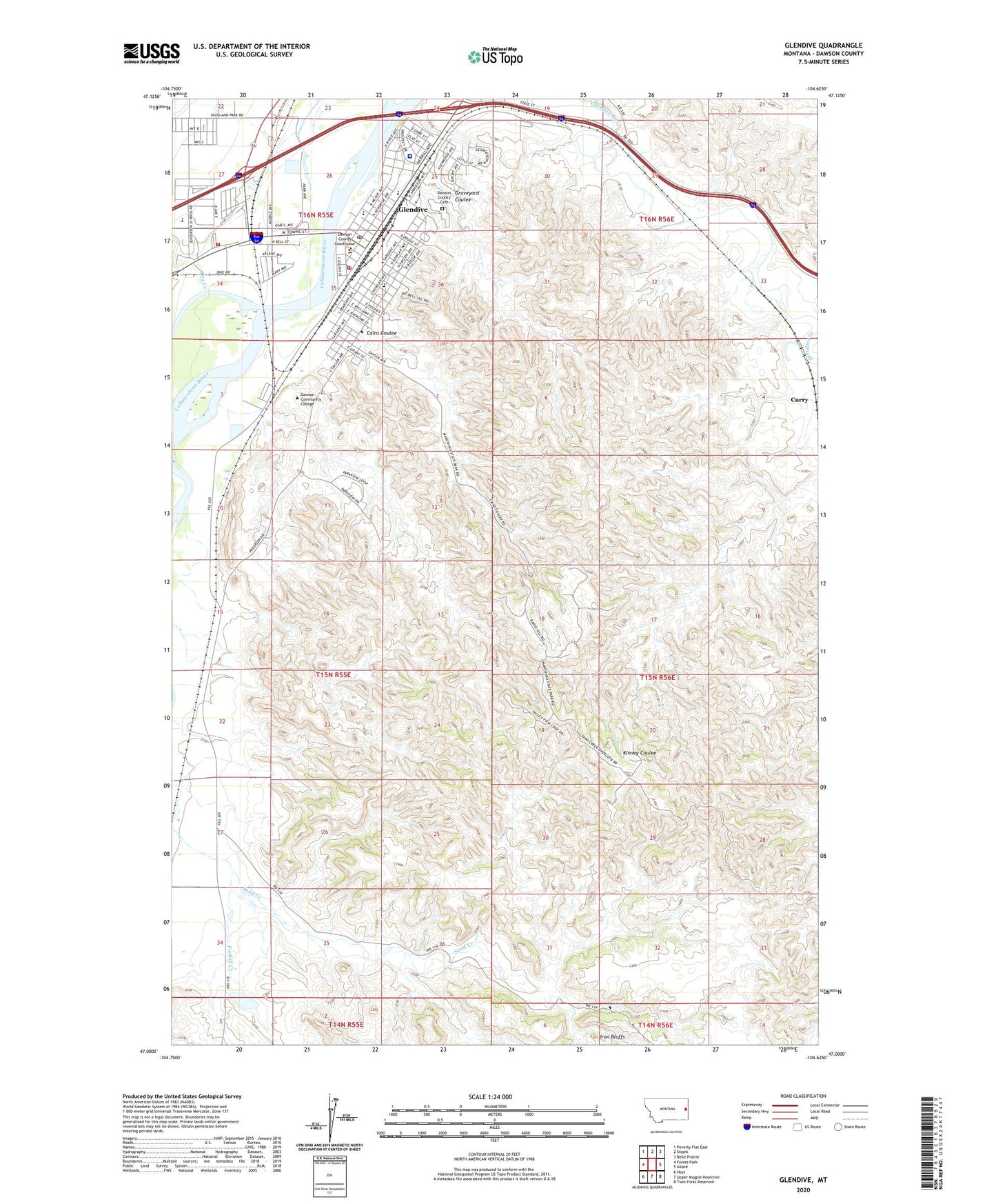
2024 topographic map quadrangle Glendive in the state of Montana. Scale: 1:24000. Based on the newly updated USGS 7.5' US Topo map series, this map is in the following counties: Dawson. The map contains contour data, water features, and other items you are used to seeing on USGS maps, but also has updated roads and other features. This is the next generation of topographic maps. Printed on high-quality waterproof paper with UV fade-resistant inks.
Quads adjacent to this one:
West: Forest Park
Northwest: Poverty Flat East
North: Stipek
Northeast: Belle Prairie
East: Allard
Southeast: Twin Forks Reservoir
South: Upper Magpie Reservoir
Southwest: Hoyt
This map covers the same area as the classic USGS quad with code o47104a6.
Contains the following named places: 15N55E12ABDC01 Well, 15N55E20BAA_01 Well, 15N55E22CACA01 Well, 15N55E23AAD_01 Well, 15N55E25ABCB01 Well, 15N55E26CCC_03 Well, 15N55E31CAA_02 Well, 15N56E04AACB01 Well, 15N56E18ACAC01 Well, 16N55E22CDD_01 Well, 16N55E23AAB_01 Well, 16N55E23BDD_01 Well, 16N55E23CC__01 Well, 16N55E24BCB_01 Well, 16N55E26BC__01 Well, 16N55E26CBA_01 Well, 16N55E26CCC_02 Well, 16N55E26CCC_04 Well, 16N55E26CCD_01 Well, 16N55E27AC__01 Well, 16N55E27BAD_01 Well, 16N55E27CAD_01 Well, 16N55E27DAD_01 Well, 16N55E27DB__01 Well, 16N55E27DCD_01 Well, 16N55E27DDC_01 Well, 16N55E33ADD_01 Well, 16N55E34AA__01 Well, 16N55E34AAA_01 Well, 16N55E34ABA_01 Well, 16N55E34ABB_01 Well, 16N55E34DA__01 Well, 16N55E35AB__01 Well, 16N55E35AB__02 Well, 59330, ABC Little League Field, Artists Vista Point, Assembly of God Church, Babe Ruth Field, Bell Street Bridge, Big Sky Chiropractic Clinic, Brueberg Hall, Cains Coulee, Cains Coulee Overlook, Cap Rock Nature Trail, Casitas Del Rio East Mobile Home Park, Christian and Missionary Alliance Church, Christian Science Society, Church of Christ, City of Glendive, Community Bible Church, Community Park, Curry, Dawson Community College, Dawson County Cemetery, Dawson County Courthouse, Dawson County High School, Dawson County Hospital, Dry Creek, Eastmont Human Services Center, Eyeful Vista Point, Eyer Park, Family Christian Fellowship, Farmers Elevator, First Baptist Church, First Congregational United Church of Christ, Forbill Creek, Frontier Gateway Museum, Gabert Clinic, Gibson Hall, Glendive, Glendive Ambulance Service, Glendive Community Hospital, Glendive Evangelical Church, Glendive Fire Department, Glendive Historical Marker, Glendive Medical Center, Glendive Plaza, Glendive Post Office, Glendive Public Library, Glendive Sewage Lagoon Dam, Glendive West Sewage Lagoon Dam, Grace Hospital, Graveyard Coulee, Green Valley Campground, Highland Mobile Home Park, Historical Landmark Park, Hungry Joe, I-94 Trailer Park, Iron Bluffs, Jane Carey Memorial Library, Jaycee West Park, Jefferson School, KXGN-AM (Glendive), KXGN-TV (Glendive), La Bree Mobile Homes Incorporated, Lincoln School, Lions Club Youth Camp, Lloyd Square Park, Makoshika State Park, Makoshika State Park Visitors Center, Montana Highway Patrol District 5 Office, Myron Number 2 Dam, Our Savior Lutheran Church, Perham Field, Pine-On-Rocks Vista Point, Prospect Heights School, Radio Hill Junction, Sacred Heart Catholic Church, Saint Matthews Episcopal Church, Samaritan Hospital, Sand Creek Overlook, Seventh Day Adventist Church, Spring Grove Trailer Court, The Church of Jesus Christ of Latter Day Saints, Thurston, Ullman Center, United Methodist Church, Washington School, West Glendive, West Glendive Fire Department, West Plaza Shopping Mall, West Side Baptist Church, Whipkey Park, White Chapel Mennonite Church, Zion Lutheran Church