MyTopo
Hoyt Montana US Topo Map
Couldn't load pickup availability
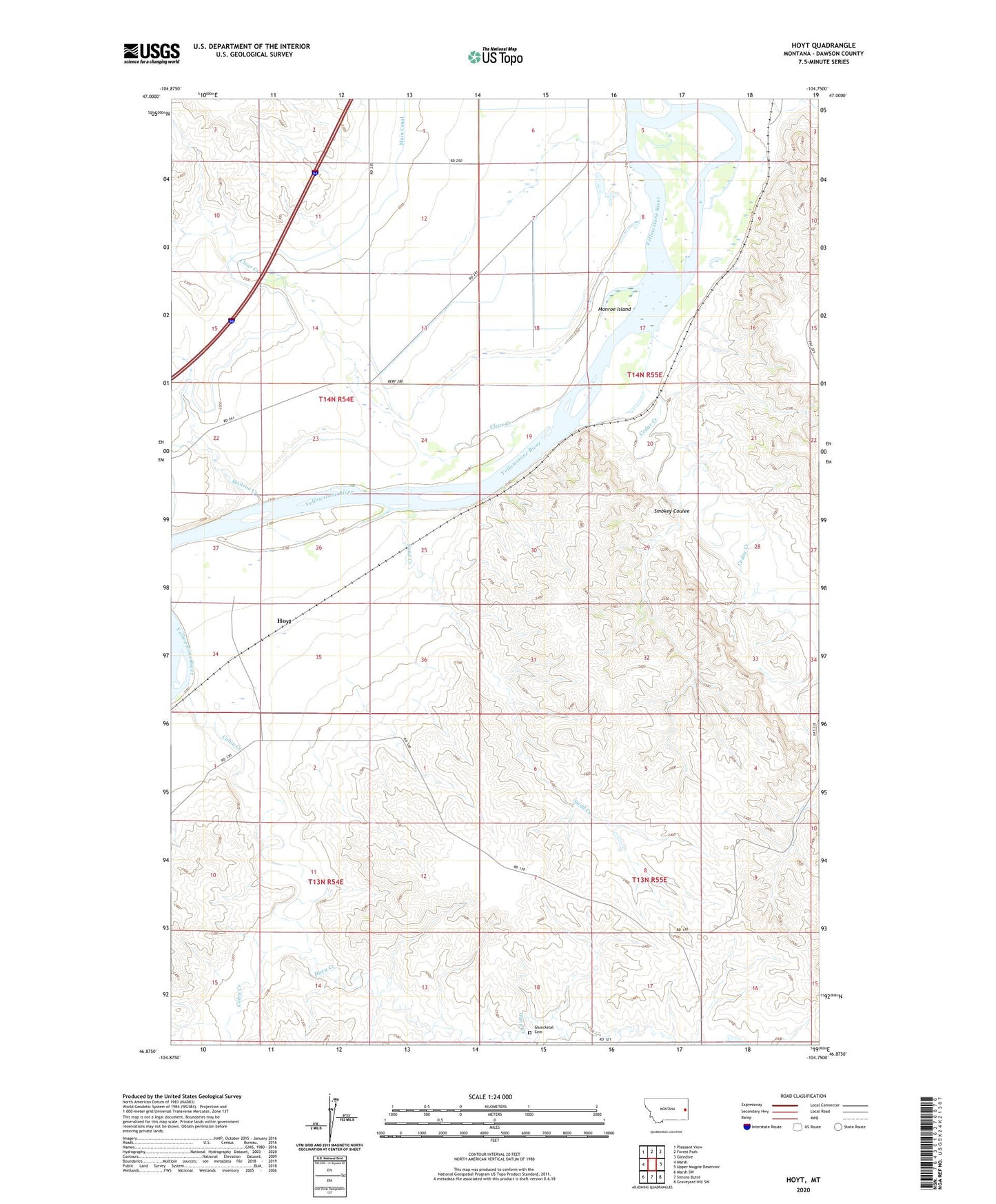
2024 topographic map quadrangle Hoyt in the state of Montana. Scale: 1:24000. Based on the newly updated USGS 7.5' US Topo map series, this map is in the following counties: Dawson. The map contains contour data, water features, and other items you are used to seeing on USGS maps, but also has updated roads and other features. This is the next generation of topographic maps. Printed on high-quality waterproof paper with UV fade-resistant inks.
Quads adjacent to this one:
West: Marsh
Northwest: Pleasant View
North: Forest Park
Northeast: Glendive
East: Upper Magpie Reservoir
Southeast: Graveyard Hill SW
South: Simons Butte
Southwest: Marsh SW
This map covers the same area as the classic USGS quad with code o46104h7.
Contains the following named places: 10N55E07CBBB01 Well, 13N53E10CAAA01 Well, 13N54E06CBD_01 Well, 13N55E07DD__01 Well, 13N55E18DC__01 Well, 14N53E15CDBD01 Well, 14N54E01CCC_01 Well, 14N54E01DAA_01 Well, 14N54E01DBB_01 Well, 14N54E12AB__01 Well, 14N54E12ACC_01 Well, 14N54E12CCA_01 Well, 14N54E12DAA_01 Well, 14N54E12DCB_01 Well, 14N54E13AAA_01 Well, 14N54E13AC__01 Well, 14N54E13BBA_01 Well, 14N54E13BBAB01 Well, 14N54E13CCA_01 Well, 14N54E13CDD_01 Well, 14N54E13DB__01 Well, 14N54E13DBBA01 Well, 14N54E13DBBB01 Well, 14N54E13DBD_01 Well, 14N54E13DCD_01 Well, 14N54E14AAA_01 Well, 14N54E14AD__01 Well, 14N54E14CAB_01 Well, 14N54E14DAA_01 Well, 14N54E22ABB_01 Well, 14N54E22BDDD01 Well, 14N54E23ABA_01 Well, 14N54E23BBD_01 Well, 14N54E23BC__01 Well, 14N54E23BDC_01 Well, 14N54E23CAB_01 Well, 14N54E23CAD_01 Well, 14N54E23DAD_01 Well, 14N54E23DBA_01 Well, 14N54E24AAB_01 Well, 14N54E24AAC_01 Well, 14N54E24ABB_01 Well, 14N54E24ABC_01 Well, 14N54E25BB__01 Well, 14N54E26CA__01 Well, 14N54E34CAAC01 Well, 14N55E04DCBD01 Well, 14N55E06ABC_01 Well, 14N55E06ACD_01 Well, 14N55E06BAA_01 Well, 14N55E06BDD_01 Well, 14N55E06BDD_02 Well, 14N55E06CAC_01 Well, 14N55E06CCC_01 Well, 14N55E06DAD_01 Well, 14N55E06DBC_01 Well, 14N55E06DDC_01 Well, 14N55E07ACA_01 Well, 14N55E07ADD_01 Well, 14N55E07BDA_01 Well, 14N55E07BDA_02 Well, 14N55E07BDA_03 Well, 14N55E07BDA_04 Well, 14N55E07BDA_05 Well, 14N55E07CAC_01 Well, 14N55E07CDD_01 Well, 14N55E07DC__01 Well, 14N55E07DCB_01 Well, 14N55E07DDA_01 Well, 14N55E18BAD_01 Well, 14N55E18CAA_01 Well, 14N55E18CCC_01 Well, 14N55E18CCC_02 Well, 14N55E18CCC_03 Well, 14N55E18CCC_04 Well, 14N55E18CCD_01 Well, 14N55E18CDA_01 Well, 14N55E18CDD_01 Well, 14N55E18DDC_01 Well, 14N55E19BAA_01 Well, 14N55E19BBD_01 Well, 14N55E29ACCD01 Well, 14N55E31CBBB01 Well, 15N55E30CDB_01 Well, Cabin Creek, Cedar Creek, Clear Creek, Glueckstal Cemetery, Hoyt, Hoyt Post Office, Hoyt School, Huey Creek, Main Canal, Monroe Creek, Monroe Island, Sand Creek, Smokey Coulee, South Fork Huey Creek, Stanleys Stockade, Townhouse Dam, Western Gravel Spur