MyTopo
Minnehaha Creek South Montana US Topo Map
Couldn't load pickup availability
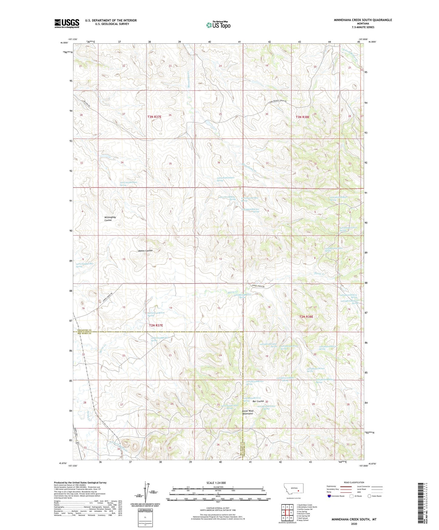
2024 topographic map quadrangle Minnehaha Creek South in the state of Montana. Scale: 1:24000. Based on the newly updated USGS 7.5' US Topo map series, this map is in the following counties: Treasure, Big Horn. The map contains contour data, water features, and other items you are used to seeing on USGS maps, but also has updated roads and other features. This is the next generation of topographic maps. Printed on high-quality waterproof paper with UV fade-resistant inks.
Quads adjacent to this one:
West: Iron Spring
Northwest: South Bear Creek
North: Minnehaha Creek North
Northeast: Griffin Coulee SW
East: McClure Creek
Southeast: Sarpy School
South: Wolf School
Southwest: Iron Spring SW
This map covers the same area as the classic USGS quad with code o45107h1.
Contains the following named places: 02N37E01ADAB01 Spring, 02N37E01ADBA01 Spring, 02N37E03BAAA01 Spring, 02N37E09ACCB01 Spring, 02N37E09BCAD01 Well, 02N37E09DDDD01 Well, 02N37E10DCBC01 Well, 02N37E11DCCB01 Well, 02N37E12CDAD01 Well, 02N37E13CCBC01 Well, 02N37E14ABBB01 Well, 02N37E14CBCC01 Spring, 02N37E15DAAA01 Well, 02N37E16DCCD01 Well, 02N37E22DBAB01 Well, 02N37E23BBCD01 Spring, 02N37E24CBCC01 Well, 02N37E25DCAD01 Spring, 02N37E27DABC01 Well, 02N37E27DCBA01 Well, 02N37E34BCDA01 Well, 02N37E34DABD01 Well, 02N37E34DACB01 Well, 02N38E04CCCC01 Spring, 02N38E05ADBA01 Spring, 02N38E06BDCA01 Spring, 02N38E07DCCC01 Well, 02N38E08ACDA01 Spring, 02N38E08DCCA01 Well, 02N38E16ADAC01 Spring, 02N38E17AAAA01 Well, 02N38E18ABBB01 Well, 02N38E18ACDB01 Well, 02N38E18BBCC01 Spring, 02N38E18DACD01 Well, 02N38E19ACAD01 Spring, 02N38E19ACDA01 Spring, 02N38E20BDAC01 Well, 02N38E20CDCA01 Spring, 02N38E20DBAC01 Spring, 02N38E20DDCA01 Well, 02N38E28ABDB01 Well, 02N38E28ABDB02 Well, 02N38E29ABBD01 Spring, 02N38E29DDCB01 Well, 02N38E29DDCB02 Well, 02N38E29DDCB03 Well, 02N38E30AABD01 Spring, 02N38E30BBCA01 Spring, 02N38E30BCCC01 Spring, 02N38E30BDDD01 Well, 02N38E30BDDD02 Spring, 02N38E32ABDB01 Well, 03N37E25CBDB01 Well, 03N37E26DACD01 Well, 03N37E26DDBB01 Well, 03N37E35CDBC01 Well, 03N37E35CDBD01 Well, 03N37E36CDDA01 Spring, 03N38E20AAAD01 Well, 03N38E20AABD01 Well, 03N38E20ABAA01 Well, 03N38E20ABAD01 Well, 03N38E20ABAD02 Well, 03N38E32CBCC01 Well, East Fork Sarpy Creek, Hays Ranch, Horse Creek, Horse Creek School, Lackey School, McRae, McRae Post Office, Pleasant Creek, Wilson Ranch, Yellow Minni Stone Dam, Yellow Sarpy Dam