MyTopo
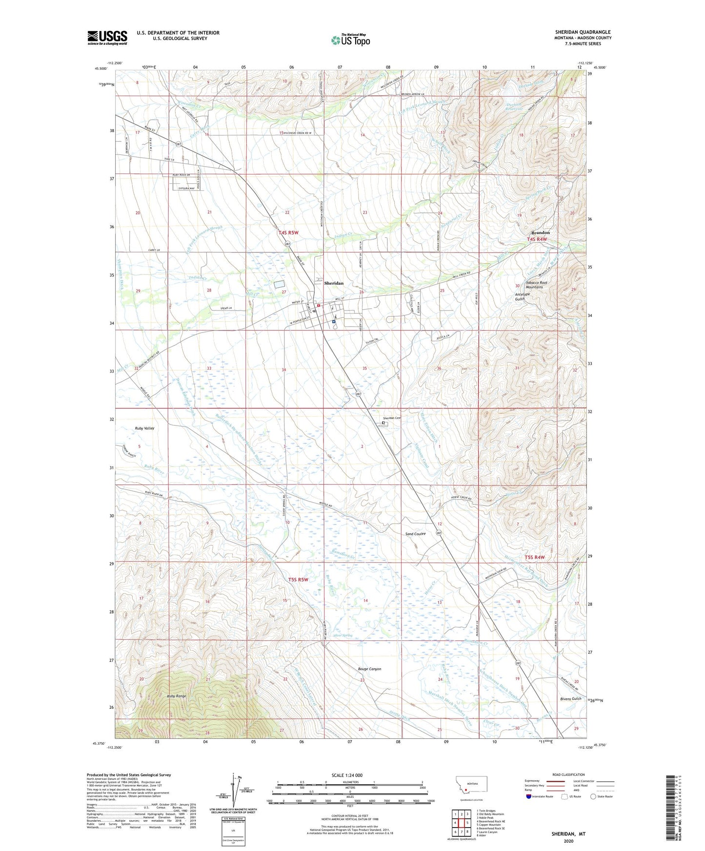
Sheridan Montana US Topo Map
Couldn't load pickup availability
Also explore the Sheridan Forest Service Topo of this same quad for updated USFS data
2024 topographic map quadrangle Sheridan in the state of Montana. Scale: 1:24000. Based on the newly updated USGS 7.5' US Topo map series, this map is in the following counties: Madison. The map contains contour data, water features, and other items you are used to seeing on USGS maps, but also has updated roads and other features. This is the next generation of topographic maps. Printed on high-quality waterproof paper with UV fade-resistant inks.
Quads adjacent to this one:
West: Beaverhead Rock NE
Northwest: Twin Bridges
North: Old Baldy Mountain
Northeast: Noble Peak
East: Copper Mountain
Southeast: Alder
South: Laurin Canyon
Southwest: Beaverhead Rock SE
This map covers the same area as the classic USGS quad with code o45112d2.
Contains the following named places: 04S04W19DDDC01 Well, 04S04W30BCBB01 Well, 04S05W11DDDD01 Well, 04S05W12CCBB01 Well, 04S05W16DDBC01 Well, 04S05W16DDCD01 Well, 04S05W27DBAB01 Well, 04S05W27DBBC01 Well, 04S05W27DBD_02 Well, 04S05W32DBCC01 Well, 05S04W19BABA01 Well, 05S04W19BABB01 Well, 05S04W19BABD01 Well, 05S05W02DDAA01 Well, 05S05W03CBBA01 Well, 05S05W03CBBB01 Well, 05S05W09DBDA01 Well, 05S05W25BAAA01 Well, 05S05W25BBBB01 Well, Antelope Creek, Antelope Gulch, Bagdad, Beaverhead - Deerlodge National Forest Madison Ranger District Sheridan Work Center, Big Chief Mine, Bivens Creek, Bivens Gulch, Bouge Canyon, Braach Ditch, Braach Mine, Branch Creek, Brandon, Brandon Census Designated Place, Brandon Mine, Brandon School, Broad Gauge Mine, Buckeye Mine, Bullerdick Hyndman Moulton Ditch, Carey Ditch, Christs Episcopal Church, Clark Sennett Ditch, Clear Creek, Colterville, Duncan Edelman Ditch, Durham Dam, Durham Ditch, Durham Reservoir, Elser Tilton Ditch, Elser-Schultz Mine, Flamm Ranch Number 1 Mine, Flamm Ranch Number 2 Mine, Fort Knox Mine, Hermsmyer Raymond Ditch, Horse Creek, Horse Creek Bull Quartz Mine, Indian Creek, Leuck Mine, Lueck Marsh Ditch, Marshall Ditch Number Three, NE SE Section 19 Mine, NE SE Section 30 Mine, Nonpariel Creek, Nugget Creek, NW NW Section 29 Mine, NW SE Section 30 Mine, Ramshorn Creek, Rattlesnake Gulch Mine, Robbers Roost, Robbers Roost Historical Marker, Robbers Roost School, Rodewald Ranch Number 1 Mine, Rodewald Ranch Number 2 Mine, Roylance Mine, Ruby Valley, Ruby Valley Ambulance Service, Ruby Valley Assembly of God Church, Ruby Valley Baptist Church, Ruby Valley Ditch, Ruby Valley Hospital, Ruby Valley Medical Clinic, Saint Joseph Parish, Sand Coulee, Schoolhouse Ditch Number One, Schulz Ditch, SE SE Section 18 Mine, SE SW Section 30 Mine, Sheridan, Sheridan Cemetery, Sheridan City Park, Sheridan Division, Sheridan Elementary School, Sheridan Post Office, Sheridan Public Library, Sheridan Trailer Court, Sheridan Volunteer Fire Department, Silver Spring, Spring Ditch, Spring Park Creek, Spring Park Creek Mine, SW NE SE Section 30 Mine, SW NW Section 20 Mine, SW SW Section 29 Mine, Tamarack Mine, Tezak's-Colterville-Spur Airport, The Church of Jesus Christ of Latter Day Saints, Thompson Ditch, Tobacco Root Mountains Care Center, Town of Sheridan, United Bethel Methodist Church, United States Forest Service Law Enforcement Sheridan Office, Vigilante Canal, West Bench Canal Lateral