MyTopo
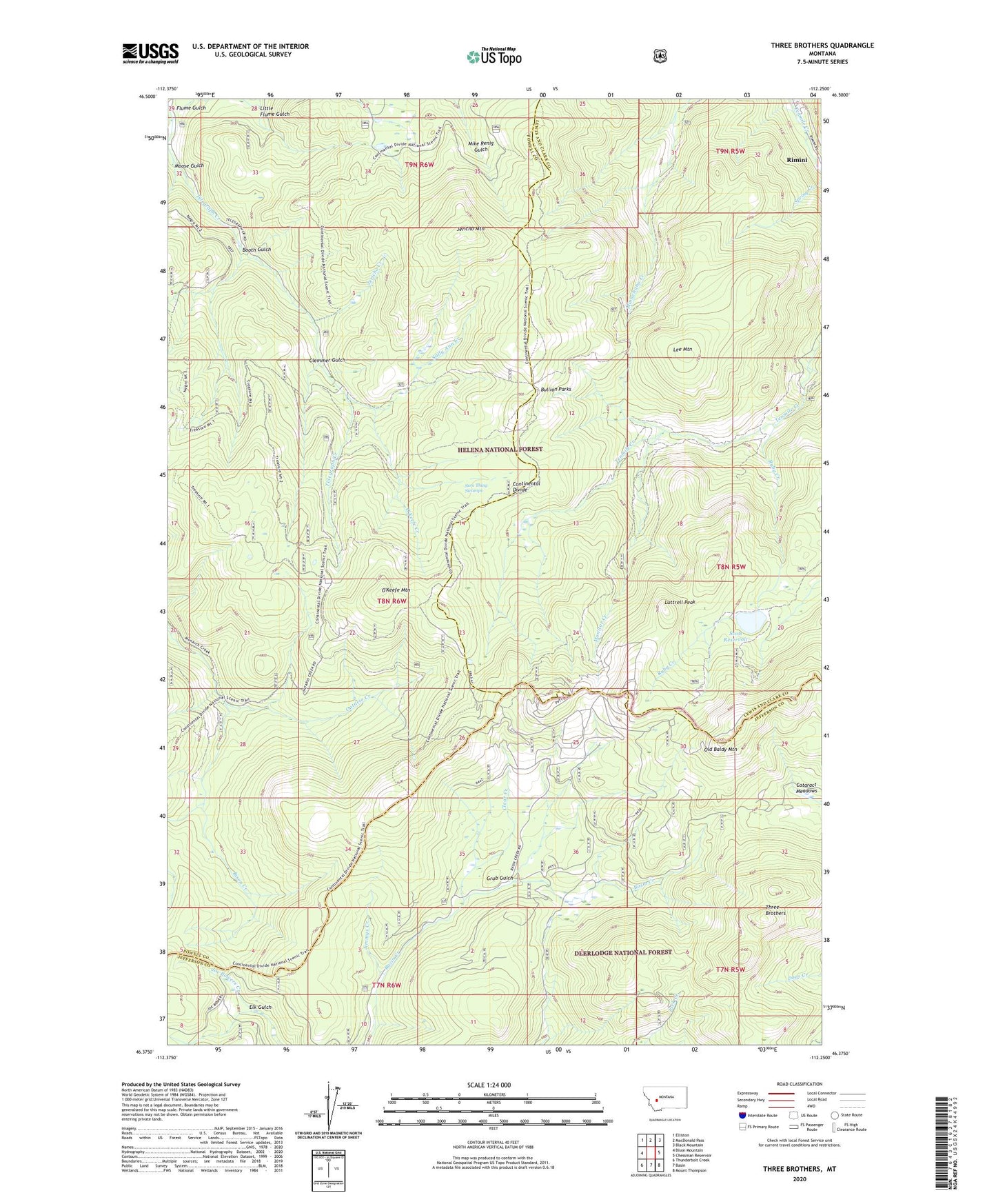
Three Brothers Montana US Topo Map
Couldn't load pickup availability
Also explore the Three Brothers Forest Service Topo of this same quad for updated USFS data
2024 topographic map quadrangle Three Brothers in the state of Montana. Scale: 1:24000. Based on the newly updated USGS 7.5' US Topo map series, this map is in the following counties: Powell, Lewis and Clark, Jefferson. The map contains contour data, water features, and other items you are used to seeing on USGS maps, but also has updated roads and other features. This is the next generation of topographic maps. Printed on high-quality waterproof paper with UV fade-resistant inks.
Quads adjacent to this one:
West: Bison Mountain
Northwest: Elliston
North: MacDonald Pass
Northeast: Black Mountain
East: Chessman Reservoir
Southeast: Mount Thompson
South: Basin
Southwest: Thunderbolt Creek
This map covers the same area as the classic USGS quad with code o46112d3.
Contains the following named places: 19 Hundred, Anna R/Hattie M Mine, Armstrong Mine, Banner Creek, Beatrice, Beattrice Mine, Bison Creek, Blue Boy, Booth Gulch, Bryan Creek, Buckeye Mine, Bullion Mine, Bullion Parks, Cataract Meadows, Champion Mine, Clear Creek, Clemmer Gulch, Close Shave, Daniel Stanton, Dan-Kim, Dorothy Snow Mine, Elk Gulch, Excelsior Mine, Flume Gulch, Grub Gulch, Hard Luck Mine, Home Stake Mine, Hub Camp, Hub Camp Mine, Jericho Creek, Jericho Mountain, Jimmy, Jimmys Creek, Josephine Mine, Justice Mine, Lady Hennessy Mine, Lady Nell/Ada Mine, Lee Mountain, Lily/Orphan Boy Mine, Lily-Orphan Boy Mine, Little Flume Gulch, Lucky Joe, Luttrell Peak, May Day, May Lillie Mine, May-Lillie Mine, Molly Snow Mine, Monitor Creek, Monte Cristo Mine, Moose Gulch, NE NW Section 23, NE NW Section 6 Mine, Newmans Camp, NW NE Section 27 Mine, NW NW Section 13, NW SW Section 15 Mine, O'Keefe Creek, O'Keefe Mountain, Old Baldy Mountain, Ontario, Ontario Millsite, Ontario Mine, Ontario Post Office, Paupers Dream Mine, Perry Parks Mine, Perry Parks Placer Mine, Peter, Placer, Placer Mine, Pocahontas, Porphyry Dike Mine, Rocker/Ada Mine, Ruby Creek, Sally Ann Creek, Scott Reservoir, Scott Reservoir Dam, SE NW Section 30 Mine, SE SE Section 13, SE SE Section 15 Mine, SE SE Section 35 Mine, Solar Mine, Spring Creek, Sure Thing Mine, Sure Thing Swamps, SW NW Section 26 Mine, SW NW Section 7 Mine, SW SE Section 10 Mine, SW SE Section 5, Telegraph Mine, Three Brothers, Travis Reservoir, West Ontario Mine, Woodrow Wilson